CYCLONE ALFRED EXPLAINER: Where it will hit and what you need to know
Northern NSW is already feeling the effects of Tropical Cyclone Alfred, which is expected to hit early on Saturday. These are the areas that are on notice.
Ahead of its expected arrival early on Saturday, Tropical Cyclone Alfred has already wreaked havoc in Northern NSW with wild winds, intense rainfall and hazardous surf inundating low-lying areas.
A severe weather warning is in place for the Northern Rivers, Mid North Coast and Northern Tablelands for heavy, locally intense rainfall and damaging to destructive winds expected over the state’s north-east.
Flood warnings are in place for Lismore, Grafton, Coffs Harbour, Tenterfield, Yamba, Woolgoolga, Sawtell and Dorrigo.
A ‘major’ flood warning applies to the Tweed River and Wilsons River, with a minor to major warning for the Bellinger River.
A moderate warning is in place for the Hastings River and a moderate to major warning is in place for the Orara River.
Here is everything you need to know about how Alfred will affect NSW residents.
This information was correct at the time of publication.
What is likely to happen?
According to the Bureau of Meteorology in northeast NSW there are heavy rainfall bands that could cause ‘dangerous and life-threatening flash flooding’ on Friday evening and early Saturday as Alfred crosses the coast.
From the QLD border to Cape Byron there are ‘damaging wind gusts’ up to 120km/h.
In island and coast areas ‘destructive’ winds are up to 155km/h. These will persist until the cyclone’s core approaches the coast.
Winds are expected to continue until early on Sunday before easing.
Abnormally high tides are predicted to cause minor flooding in coastal low-lying areas bvetween Double Island Point down to Grafton – likely late on Friday and early Saturday.
Hazardous surf warnings are in place along the NSW east coast.
How fast is Alfred moving and will its strength change?
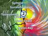
Alfred is currently moving slowly; it is tracking southwest at 6km/h and is forecast to stay a category 2 until the centre starts to interact with the coast and islands.
The Bureau of Meteorology reported at its centre winds are 100km/h with gusts of 140km/h.
When will Cyclone Alfred make landfall in NSW?
Current predictions are for Alfred to hit the coast early on Saturday.

Which regions will be affected?
NSW will be affected from the QLD state border to Grafton (not including Grafton). Conditions may change rapidly.
The exact path of the cyclone will become clearer about six hours before landfall, Mr Hinterdorfer told The Courier-Mail– affected residents are advised to seek shelter from this time.
What intensity is Cyclone Alfred?
At the time of publication the cyclone was classified by the Bureau of Meteorology as category 2.
This means:
- Typical wind gusts are 125-164km/h
- Maximum mean wind speed is 89-117km/h
- Winds are considered ‘destructive’
- Minor damage to homes
- Significant damage to signs, trees and caravans
- Heavy damage to crops
- Risk of power failure
- Small craft may break moorings
Where to find sandbags
Sandbags are available at SES units and self-serve stations.
Those using the service must bring their own shovel.