
Timeline: Inside the moment of and aftermath of Alfred’s landfall
Tropical Cyclone Alfred is now an ex-tropical cyclone and is crossing into Queensland, with four million people in the firing line. This is what you can expect.

QLD weather news
Don't miss out on the headlines from QLD weather news. Followed categories will be added to My News.
A well-known storm chaser has given an insight into what people living in South East Queensland could experience as TC Alfred makes landfall.
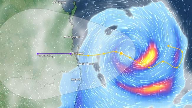
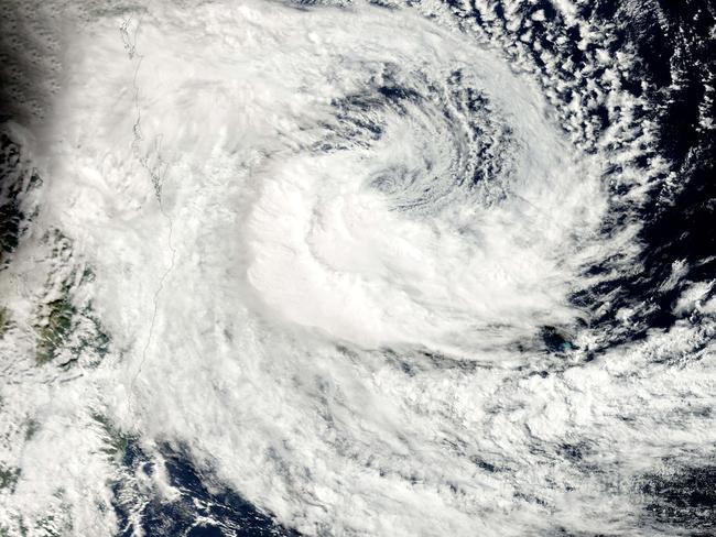
Tropical Cyclone Alfred was downgraded to a tropical low after crossing islands off Queensland early Saturday as category 1 system – packing gale-force winds and dumped huge amounts of rain to the south of the eye.
A cyclone in Brisbane is something many have never experienced, with Queensland Premier David Crisafulli reminding Queenslanders that it has happened in the past and it is expected to happen this week.
“I know this is not a frequent occurrence, and there may be Queenslanders who can be forgiven for thinking this is something that doesn’t occur,” he said.
While cyclones are inherently unpredictable in nature and all you can do is prepare for the worst and hope for the best, Thomas Hinterdorfer of Higgins Storm Chasing has given an insight into what Queenslanders could expect.
JUST BEFORE TC ALFRED MAKES LANDFALL
At around six hours before TC Alfred strikes, Mr Hinterdorfer said exactly where it will make landfall will become very clear.
“Once we’re honing in on the exact area that makes landfall, we’re probably looking at winds of around 140-160km/h,” he said.
“Those higher winds will start to impact places like Moreton Island, North and South Stradbroke Island, those sort of areas are exposed because the system won’t quite be on land yet.”
Residents are advised to seek shelter from this moment.

THE MOMENT TC ALFRED MAKES LANDFALL
Mr Hinterdorfer said there will be a gradual lead-up to the moment.
“Wind increases will be very gradual in the lead up to landfall,” he said.
“On landfall, there will be widespread strong to damaging winds across the entirety of SEQ.
“You’re going to see those destructive winds around the centre of the system, you’ll start to see the true impacts with trees coming down, power lines coming down, some minor structural damages really close to the centre of the system.
“Power outages are a possibility, especially with downed lines – trees could fall on power lines and knock them down.
“When you’ve got those higher end winds near the centre of the system, you’re looking at minor structural damages, which could be roofs, impacted windows, any loose items are going to go flying.
“Rain will become absolutely relentless, it’s going to stay squally the entire time through the landfall.
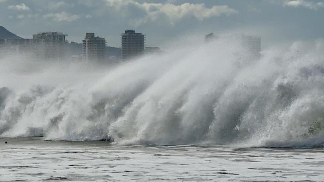
“Beach conditions during landfall are going to be beyond treacherous.
“We’re looking at waves between six and eight metres across areas very close to the coast, and then offshore from the coast, they could be exceeding 10 metres.
“Those sort of waves will be causing significant and potentially even irreversible beach erosion.”
INSIDE THE EYE OF TC ALFRED
Mr Hinterdorfer said those that live in the area where the eye of TC Alfred passes, will briefly experience a period of eerie calmness on either side of incredibly destructive winds.
“Just coming up to the eye you get really strong winds, damaging, destructive winds,” he said.
“Then as the eye moves over you, the wind will go calmer, it may not go dead still, but it will be noticeably calmer.
“And then once that eye starts to move off, and that’s where you could start to see your more damaging winds, the ones that do cause more structural damage
“It may only be a very small eye with this system, it may only be one or two towns, a handful of suburbs, that get to experience it, but for those people, it’s going to be absolute mayhem.”
THE AFTERMATH OF TC ALFRED
After TC Alfred passes, Mr Hinterdorfer said there will be a significant accumulation of rainfall and a high risk of floods.
“In the aftermath of landfall, that is where we start to see rainfall totals start to accumulate, and obviously our flood risk will skyrocket through there widespread flash flooding, significant and potentially life threatening flash flooding,” he said.
“There may be moderate to major river and creek flooding, and that could be across numerous rivers through South East Queensland.”
SAFETY ADVICE
Alerts will be issued by the Bureau of Meteorology, relevant emergency services, and council disaster dashboards in the lead up to Tropical Cyclone Alfred.
While roads won’t be closed, unless they are flooded, if you don’t have an essential reason to be on the road in the height of Tropical Cyclone Alfred, people are advised to remain off the roads.
Your local council’s disaster dashboard will have the most up to date information including storm surge information and mapping.
Residents are also advised to have a battery-powered radio, in case power outages take place.


‘Gets pretty wild’: Qld weather buff on the spot for epic US storms
A Queensland weather forecaster shares unbelievable images after he spent almost three months chasing tornadoes in the US this year.

MINUS 3.1C: Brutal cold snap as Qld temps drop to lower than Hobart
Parts of Queensland have woken up to subzero temperatures which triggered widespread frost with the weather bureau warning the big freeze is going nowhere.