
The Bureau of Meteorology has predicted more heavy rain to fall across the Northern Rivers
BOM predicts more heavy rain for the Northern Rivers for the coming days.
Lismore
Don't miss out on the headlines from Lismore. Followed categories will be added to My News.
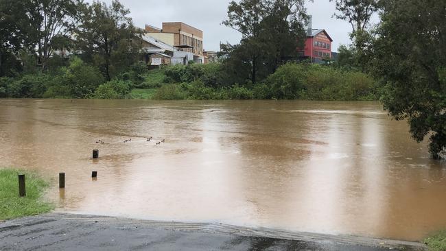
UPDATE 4.55pm: Motorists and business owners in low lying areas of the CBD are advised to be aware of the risk of flash flooding overnight as the Wilsons River rises and the council close levee gates this evening.
Carparks on the riverside of the levee have already been closed.
The BOM is forecasting heavy rain overnight and the Wilsons River is predicted to reach the minor flood level of 4.2m later tonight and may reach 5m tomorrow, Lismore City Council's Local Emergency Management Officer Scott Turner said this afternoon.
"We will commence closing levee gates this evening and this means heavy rain falling directly in the Lismore basin could cause flash flooding in the CBD similar to what we experienced just before Christmas," he said.
Motorists are advised not to park their vehicles in low-lying areas around Dawson Street and Uralba Street and CBD businesses affected by the pre-Christmas flash flood are advised to be ready to move equipment, vehicles and stock to higher ground.
Residents are urged to monitor conditions and be prepared for potential flash flooding.
In life-threatening emergencies, call 000 (triple zero) immediately. If you require rescue, assistance to evacuate or other emergency help, ring NSW SES on 132 500.
Avoid drowning. Stay out of rising water, seek refuge in the highest available place.
Prevent damage to your vehicle. Move it under cover, away from areas likely to flood.
Avoid being swept away. Stay out of fast-flowing creeks and storm drains.
Never drive, ride or walk through flood water. Flood water can be deceptive and dangerous.
UPDATE 4.15pm: An initial flood warning has been issued for the Wilsons Rivers and other North Coast rivers are on flood watch.
The Wilsons River at Lismore is expected to exceed Minor Flood level of 4.20m on Monday night, and reach 5m on Tuesday afternoon.
The SES said communities in the Northern Rivers region are being asked to brace themselves for potential flooding this week.
Heavy rainfall has the potential to cause minor flooding from today through to the middle of the week throughout the Northern Rivers, with the Bureau of Meteorology issuing a flood watch for a number of local catchments.
Northern Rivers Zone Commander for the NSW SES, Chief Superintendent Steve Patterson, said the catchments to be affected by flooding are currently very wet following recent rainfall.
"This weather system is expected to cause flooding for the catchments listed from today and into the week," Chief Supt Patterson said.
River catchments expected to be affected are:
• Tweed and Rouse Rivers
• Wilsons River
• Richmond River
• Clarence River.
"This Flood Watch means that people living or working along rivers and streams must monitor the latest weather forecasts and warnings and be ready to move to higher ground should flooding develop," Chief Supt Patterson said.
"Flood Warnings will be issued if Minor Flood Level is expected to be exceeded at key sites along the main rivers for which the Bureau of Meteorology provides a flood warning service."
Chief Supt Patterson said people who may be affected by the impending weather should take the time now to prepare their property for potential flooding.
"This includes moving stock to higher ground, moving pumps for creeks and rivers and having adequate resources on hand including food and water, should your property become isolated for a period of time," he added.
NSW Police and emergency services are reminding the community to take care as the wet weather continues to impact large parts of the state.
The Public Information and Inquiry Centre (PIIC) will continue to support the severe weather operation this week and can be contacted by calling 1800 227 228.
Members of the public can contact the PIIC for general information related to the severe weather and flooding. It will operate on a 24 hours basis until at least 5pm on Friday (March 26).
State Emergency Operations Controller, deputy commissioner Gary Worboys, has reminded the public to exercise caution as regions across the state were bracing for further rainfall and many river systems yet to reach their peak.
"Members of the public in the flood affected areas need to continue to heed the warnings and advice of the NSW State Emergency Service and all emergency services," Deputy Commissioner Worboys said.
"The message from Police and SES has been consistent for the last few days - if possible, avoid going outside and if you do drive, plan ahead - pay attention to RMS message boards for road closures or hazardous conditions, and never drive, ride or walk through floodwater.
"Do not put your life or that of emergency service personnel in danger," he said.
It should be noted the PIIC inquiry hotline is for general enquiries does not replace the State Emergency Service emergency hotline.
Members of the public seeking emergency assistance during a flood or storm should call the NSW State Emergency Service on 132 500, or visit their website www.ses.nsw.gov.au
For life threatening emergencies, the public are advised to contact Triple Zero.
UPDATE, 2.40pm: An initial Minor Flood Warning has been issued for the Wilsons River at Lismore.
The Bureau of Meteorology says minor flooding is expected from Monday night.
"Heavy rainfall since Saturday over the Lismore River catchment has caused river rises, and minor flooding is likely in the Wilsons River at Lismore from Monday night," the warning states.
"Further rainfall is possible over the coming days, and this may lead to further rises.
"The Wilsons River at Lismore (AHD) is below the minor flood level and rising.
"The Wilsons River at Lismore (AHD) is expected to exceed the minor flood level (4.20m) Monday night.
"The river level may reach around 5m Tuesday afternoon."
UPDATE 12.25pm: A severe weather warning is in place for most of NSW today.
The Bureau of Meteorology said a strong high pressure system over the southern Tasman Sea continues to drive widespread and persistent rain onto the New South Wales coast. This is expected to continue today, particularly about the Mid North Coast and Northern Rivers.
On Tuesday, as the trough reaches the Tasman Sea, a low pressure system may form, bringing increased rainfall, strong winds, damaging surf and abnormally high tides to the east and south.
Most areas of New South Wales will see a clearing trend early Wednesday as a drier airmass moves into the region.
EASTERN AREAS:
Heavy rain, likely leading to flash flooding, presents a serious risk to the Northern Rivers and Mid North Coast today and on Tuesday.
In some areas, heavy rain and flooding may be life-threatening.
A hazardous surf warning is also in place for the Byron Coast.
Roads in some areas are cut off by water, and there is an increased risk of landslips during this period. In addition, super-saturated soils along areas of the east bring an increased risk of moderately gusty winds toppling trees.
River catchments in this area are wet, bringing an enhanced risk of renewed riverine flooding. Numerous flood watches and warnings are current. Latest updates at http://www.bom.gov.au/nsw/warnings/.
Locations which may be affected include Lismore, Grafton, Coffs Harbour, Port Macquarie, Taree, Newcastle, Sydney, Wollongong, Nowra, Batemans Bay, Armidale, Orange, Canberra, Goulburn, Tamworth, Moree, Dubbo, Tibooburra, Cobar and Bourke.
Rainfall observations to 9am Monday include:Houghlahan's Creek 193mm
Nashua (Wilsons River) 198mm
Alstonville 187.8mm
Coffs Harbour 183mm
Woolgoolga 182mm
UPDATE 10.40am: The Bureau of Meteorology said flooding is expectedfor much of the NSW coast today, including parts of the Northern Rivers.
On top of the existing Flood Warnings, rainfall associated with a deepening low pressure trough over western NSW has the potential to cause minor to major flooding over parts of the NSW East Coast and parts of the South West, Central West and North West.
A Severe Weather Warning is current.
Catchments likely to be affected by flooding are currently wet due to recent rainfall.
The weather system is expected to cause flooding for the catchments listed from Monday onwards.
Catchments likely to be affected include:
Tweed and Rouse Rivers - minor flooding
Wilsons River - minor flooding
Richmond River - minor flooding
Clarence River- minor to moderate flooding catchments.
Be aware heavier than expected rain can cause these flood levels to be exceeded.
Flood Safety Advice:
This Flood Watch means that people living or working along rivers and streams must monitor the latest weather forecasts and warnings and be ready to move to higher ground should flooding develop.
Flood Warnings will be issued if Minor Flood Level is expected to be exceeded at key sites along the main rivers for which the Bureau of Meteorology provides a flood warning service.
Severe Weather Warnings will be issued or updated if very heavy rain is forecast or observed.
UPDATE 10.10am: As of 9.30am Monday, Ballina airport has most flights still scheduled to arrive from Sydney, Canberra, Melbourne and Dubbo.
Only one FlyPelican service from Newcastle has been cancelled today, as Newcastle's airport has been closed down due to flooding.
As of 6.10pm Sunday, 21 March, flights in and out of Newcastle Airport have been suspended, due to local flooding of the airfield.
Given the condition of the runway and an unfavourable weather forecast, the closure in Newcastle is currently scheduled to remain in place until Midday Wednesday, 24 March.
UPDATE 9.50am: A hazardous surf warning has been issued for New South Wales.
Surf and swell conditions are expected to be hazardous for coastal activities such as rock fishing, boating, and swimming in the following areas.
Impacted areas include Byron Coast, Coffs Coast and Macquarie Coast.
Safety Advice
NSW Police Force, Marine Area Command advise that:
- People should consider staying out of the water and avoid walking near surf-exposed areas.
- Rock fishers should avoid coastal rock platforms exposed to the ocean and seek a safe location that is sheltered from the surf.
- Boaters planning to cross shallow water and ocean bars should consider changing or delaying their voyage.
- Boaters already on the water should carry the appropriate safety equipment and wear a lifejacket.
- Boaters should remember to log on with their local Marine Rescue radio base, via VHF Radio or the Marine Rescue APP, and consider their safety management plan.
Original story: Locations on the Northern Rivers received up to 180mm of rain in seven hours yesterday, and could receive up to another 100mm today.
>>> Road closures around the region
Houghlahans Creek, Nashua and Alstonville topped the rain charts yesterday, with 181mm recorded at Houghlahans Creek from 9am yesterday to 4am this morning.
The rainfall predictions for today are:
Today (Monday) Lismore is predicted to get 60-100mm, Tuesday 35-60mm, clearing to showers on Wednesday, with a top temperature of 29C, before becoming sunny on Thursday and Friday.
The rest of the Northern Rivers can expect much of the same.
Casino can expect between 70-120mm of rain on Monday and 35-60mm on Tuesday.
Tweed Heads is forecast to receive 50-80mm on Monday and 50-90mm on Tuesday.
Byron Bay can expect 45-80mm on Monday and 40-70mm on Tuesday.
The forecast for Ballina is 60-100mm on Monday and 35-70mm on Tuesday.
Kyogle is also forecast to receive a drenching, with 60-100mm on Monday and 30-50mm on Tuesday.
Evans Head could get 60-100mm of rain on Monday and a further 40-70mm on Tuesday.
A strong high pressure system over the southern Tasman Sea continues to drive widespread and persistent rain onto the New South Wales coast. This is expected to continue today, particularly about the Mid North Coast and Northern Rivers.
Meanwhile, a low pressure trough in the state's west is deepening, bringing rain areas to the northern inland today.
On Tuesday, as the trough reaches the Tasman Sea, a low pressure system may form, bringing increased rainfall and strong winds to the southeast.
Most areas of New South Wales will see a clearing trend later Tuesday or early Wednesday as a drier air mass moves into the region.
Heavy rain, likely leading to flash flooding, presents a serious risk to the Northern Rivers and Mid North Coast today and on Tuesday. Some risk remains for the Hunter and Central Tablelands districts during this period, particularly given the saturated nature of catchments. In some areas, heavy rain and flooding may be life-threatening.
Roads are likely to be cut off by water, and there is an increased risk of landslips during this period.
River catchments in this area are wet, bringing an enhanced risk of renewed riverine flooding. Numerous flood watches and warnings are current.
Widespread rainfall may lead to riverine flooding, and a Flood Watch is current for catchments on the western slopes.
Locations which may be affected include Lismore, Grafton, Coffs Harbour, Port Macquarie, Taree, Katoomba, Tamworth, Dubbo, Tibooburra, Cobar and Bourke.
Rainfall observations from 9am Sunday to 4am Monday include:
• Minnie Water Pump Shed 241mm
• Houghlahan's Creek 181mm
• Nashua (Wilsons River) 180mm
• Alstonville STP 173mm
• Wooli (Sportsground) 171mm
The State Emergency Service advises that people should:
• Don't drive, ride or walk through flood water.
• Keep clear of creeks and storm drains.
• If you are trapped by flash flooding, seek refuge in the highest available place and ring triple-0 if you need rescue.
• Be aware that run-off from rainfall in fire affected areas may behave differently and be more rapid. It may also contain debris such as ash, soil, trees and rocks.
• After bushfires, heavy rain and the loss of foliage can make the ground soft and heavy, leading to a greater chance of landslides.
• Stay vigilant and monitor conditions. Note that the landscape may have changed following bushfires.
• For emergency help in floods and storms, ring your local SES Unit on 132 500.

‘Sense of entitlement’: Accounts worker jailed for ‘outrageous’ fraud
A trusted worker who defrauded a Mid-North Coast company out of more than $500,000 in one year, and spent it on various ‘lifestyle’ items, was motivated by ‘greed’. Here’s her sentence.

‘Life or death’: Alarm over city judges ruling on bush bail cases
A plan to have city magistrates remotely dealing with bail applications from the country has raised alarm about fairness and the possibility of recidivist offenders getting out more often.