
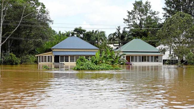
North Lismore homes flooded 40cm higher than data suggested
PEOPLE are being warned not to use Lismore City Council's floor height data as an exact indication of the impact of a flood on their homes.
Lismore
Don't miss out on the headlines from Lismore. Followed categories will be added to My News.
NORTH Lismore residents are being urged not to trust Lismore City Council's floor height data after the March 31 flood inundated homes up to 40cm more than expected.
Even Lismore City Council itself has advised residents not to put iron clad faith in the floor height information during a flood.
The data, available on the council's website, gives floor heights of every address exposed to flooding in the Lismore basin.
It's available here.
Local weather watcher Tim Somerville described it as the "bible" for predicting the impact of the floods on vulnerable homes in North Lismore. However, Mr Somerville has concluded that it failed locals dismally on March 31.
He cited one Alexandra Parade address which has a documented floor height of 11.37m and therefore should have had only 22cm of water in it, based on the 11.59cm flood peak.
But in the actual flood the water peaked at 61cm above the floor, and the difference in expected flooding had huge consequences for the residents' loss of possessions.
"That person put their stuff up on beds. When we came in everything was floating around, because the beds were submerged," he said.
Another address on Terania St sat at 11.76m according to council floor data, which Mr Somerville said should have been 17cm clear of the flood.
Instead it was submerged in 22cm of water.
Interestingly, the difference between the expected flood depths and the actual flood depths at both properties was exactly 39cm.
Mr Somerville said if the floor height data was wrong, "that's unacceptable, because that's a sunny day failure".
"To people running about in the chaos of the event, that floor height (data) is everything."
However, Lismore City Council has itself advised residents the data may not be precise.
In fact the document has a very prominent disclaimer which says the information "has not been independently verified and is not endorsed by the Council as without error, omission or misdescription".
Lismore councillor and flood engineer Bill Moorhouse advised people not to treat the document as gospel in a flood, because it naturally didn't take into account the fact that water flows downhill and floods will always be higher upstream.
This phenomenon is called "hydraulic gradient".
"We've had this problem before. People don't understand hydraulic gradient," he said.
"The further (upstream) you are, the higher the actual level of the flood."
With water running downhill from North Lismore to the actual gauge at the rowing club, and Mr Moorhouse said a flood peak of 40cm at North Lismore above the official peak at the rowing club was "what you would expect".
The March 31 flood peaked at 11.59m, but Mr Moorhouse said people upstream "have to have a floor level substantially higher than that to be out of flood, because they're further upstream".
By the same token, he said "if you're 11.6m downstream, the probability is you're going to be further out of the wet".
"You cant just say it's 11.6m at the gauge therefore I won't get flooded (if my floor is higher than that). You've got to allow for that hydraulic gradient."
But because every flood is different, he said it was impossible to predict what the exact gradient is between upstream locations and the Lismore gauge.
"It's different every time, it depends how fast the river's flowing in different places, and how wide the river is," he said.
All floor heights provided by the council use Australian Height Datum, which is a standardised height above mean sea level.

‘Gangbangs’: ‘Disgusting’ fake revenge ad lands man in court
As an act of revenge, a builder posted a fake online ad depicting a woman being available for sexual services, resulting in her receiving a barrage of proposals for sex - including “gangbangs”.

Woman’s despair after tobacconist firebombing destroys home
A woman living above a firebombed northern NSW tobacconist has been left devastated after the inferno ripped through her home, leaving her with “nothing but the clothes on her back”.