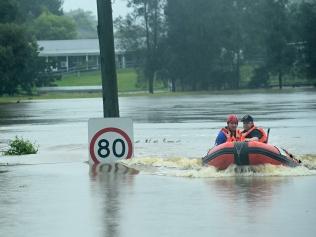
A morning flood update from the Bureau of Meteorology revealed major flooding was still underway at North Richmond, and moderate flooding at Windsor and Sackville.
But the river has peaked in both locations below the flood level seen in March 2021.
However, urgent evacuation orders have been issued for residents of Wisemans Ferry, Lower Portland and Cumberland Reach as floodwaters along the Hawkesbury move downstream and threaten low-lying homes.
"Along the Hawkesbury and Lower Nepean Rivers Major flooding continues at North Richmond where river levels peaked Thursday afternoon, below the March 2021 event," the BOM wrote."
"River levels at Windsor peaked below the major flood level (12.20m) early Friday morning."
"The Hawkesbury River at North Richmond peaked at 12.95m around 02.45 pm Thursday and is currently at 12.24m and falling, with major flooding."
"The Hawkesbury River at Windsor peaked at 11.99m around 02.30 am Friday, with moderate flooding."
Minor flooding is still happening in Penrith, while Wisemans Ferry and Lower Portland are on alert for moderate flooding.
Further rainfall is forecast on Friday which may result in extended flood peaks.
Read Friday morning's updates below.
Updates
Parts of NSW could get up to 100mm, according to the Bureau of Meteorology.
SES crews rescued a woman from a car overnight after her vehicle became trapped in floodwaters.
Sutherland Shire SES, who were helping out other Sydney units due to widespread flooding in the Sydney area, rescued a woman whose car had become partially submerged.
"Thankfully she was rescued without further incident and is now at home warm & safe," the SES shared online.
The clean up in Northern NSW has begun but the region isn't yet clear of further flood danger, the State Emergency Service Commissoner has warned.
Carlene York said on Friday that 600 extra resources had been set up in the flood-stricken region to help with the recovery effort in the coming days.
But Comm York said the forecast of more bad weather from the Bureau meant locals couldn't let down their guard yet.
"Based on the forecast from the Bureau, we're not past the danger period yet," Comm York said.
"The river is very fast flowing, there's a lot of debris and it's very dangerous out there… these thunderstorms and isolated heavy showers create an additional risk to the community."
She reminded residents not to drive through floodwaters to try and return to their homes.
"We have great emhpasis at the moment on trying to clear those areas that are safe to let you back in but obviously with those high levels of water rushing down the rivers… it's still very dangerous out there," she said.
Comm York also asked South Coast residents to prepare for heavy rainfall and thunderstorms in the coming days as a second wet weather system threatens eastern NSW.
More rain is expected over the weekend in NSW's east, with "bad news" for flood stricken areas which could see the water remain for some time yet.
BOM spokesman Dean Narramore said waters were starting to dip in the Northern Rivers, where Lismore's Wilson River is now at a minor flood level, and that the Hawkesbury has already peaked at Windsor.
But he said major flooding would still persist in some areas, buoyed by further rain expected as part of a forming low pressure system.
Severe thunderstorms are expected in the Northern Rivers this afternoon, showers will move up from the Illawarra to the Hunter today creating "bursts of heavy rainfall, and on Saturday storms will form in the Riverina and move north up the South Coast.
"Shower and thunderstorm activity will likely become widespread on Sunday and include the Illawarra, Central Coast and the Hunter… some guidance has hinted to another low pressure system developing along the coast of NSW Sunday into Monday," Mr Narramore said.
"We're looking at widespread shower and thunderstorm activity developing across much of eastern NSW… that is not good news for us."
He added: "While showers and rainfall have eased today and tomorrow we still have nuermous moderate to major flood warnings, and when we've got this next weather system moving in to bring another round of rain… we could have prolonged moderate and major flood warnings."
The Hunter is now on alert for moderate to major flooding after the east coast slow swamped the region with rain yesterday.
The Bureau of Meteorology's Dean Narramore said a "widespread 50 to 100mm" had fallen, creating conditions for moderate to major flooding on river ssystems.
"We have moderate to major flooding occuring on rivers across the Hunter region, the Patterson and Williams River is in moderate flood and we could see major flooding on the Gloucester River," Mr Narramore said.
"We could also see moderate flooding in the towns of Wingham and Taree."
Mr Narramore said up to 200mm had fallen at Barrington Tops too.
Here's the rain totals on the Central Coast, in Sydney and in the Illawarra and South Coast, since 9am on Thursday, according to the Bureau of Meteorology:
- Gosford: 48.6mm
- Maitland: 39mm
- Mangrove Mountain: 71.8mm
- Newcastle: 36.6mm
- Badgerys Creek: 12.6mm
- Bankstown: 21.8mm
- Camden: 13.4mm
- Campbelltown: 10.2mm
- Canterbury: 31.8mm
- Holsworthy: 22mm
- Horseley Park: 23.6mm
- Lucas Heights: 27.9mm
- Richmond: 25.8mm
- Sydney Airport: 22.8mm
- Sydney Olympic Park: 26.6mm
- Terrey Hills: 32.2mm
- Albion Park: 62.8mm
- Jervis Bay: 41.8mm
- Moss Vale: 28.2mm
More than 100 additional police have been deployed in Northern NSW to help with flood recovery.
The additional officers, from multiple Sydney metro Police Area Commands and specialist units across NSW, arrived in the state's north on Thursday.
The extra police will support local officers in Lismore, Tweed Heads, Ballina and surrounds as the rescue and recovery efforts continue.
They will be deployed to support local police attached to Richmond Police District and Tweed/Byron Police District, covering the areas of Lismore, Tweed Heads, Ballina and surrounds.
Deputy Premier and Minister for Police Paul Toole said the extra police resources will make a significant contribution to the emergency response in flood-ravaged areas.
“Rest assured we are throwing every resource at this evolving situation, and deploying these extra officers will make a huge difference on the ground, not only in the immediate response phase, but also during the long road to recovery," Mr Toole said.
Here's the latest on the roads in Northern NSW:
- Ballina Road has reopened at Lismore but other roads remain closed in the Lismore CBD, including Dawson Street.
Major road closures remain in place, including:
- Glenugie to Tintenbar: The M1 Pacific Motorway and Pacific Highway is closed in both directions.
- West Ballina to Uralba: Bruxner Highway is closed and between Sandilands and Malanganee also at South Lismore between Caniaba Road and Elliott Road.
- South Grafton to Clarenza: Big River Way is closed.
- Big River Way is also closed at Tyndale.
- Thora to Dorrigo Mountain: Waterfall Way is closed due to a landslide.
Many other local roads are closed, with motorists urged to check local council pages and social media sites for updates.
The Traffic Management Centre said: "Motorists in the state's north are still advised to take extreme care and avoid non-essential travel in flooded areas."
Here's the latest on Greater Sydney roads from the Transport Management Centre:
- Wakehurst Parkway has reopened in both directions between Narrabeen and Oxford Falls.
- Newbridge Road reopened overnight in both directions between Milperra and Chipping Norton.
- Cattai Ridge Road also reopened through Glenorie.
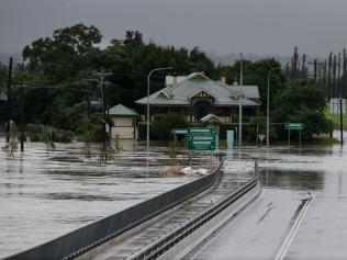
Road closures that remain in place are: - Windsor Bridge, North Richmond Bridge and Yarramundi Bridge are closed.
- Windsor: Hawkesbury Valley Way is closed between Moses Street and Percival Street.
- Riverstone: Garfield Road West is closed between Pacer Street and Cemetery Road.
- McGraths Hill: Windsor Road is closed between Pitt Town Road and Macquarie Street.
- McGraths Hill and Cattai: Pitt Town Road, Cattai Road and Wisemans Ferry Road are closed.
- Wallacia: Silverdale Road is closed over the Nepean River.
- Douglas Park: Douglas Park Causeway is closed.
- Oxford Falls: Oxford Falls Road is closed between Wakehurst Parkway and Aroona Road.
- North Turramurra: Bobbin Head Road is closed between Memorial Road and Ku-Ring-Gai Chase Road.
- Galston and Hornsby Heights: Galston Road remains closed.
- Royal National Park: Audley Weir remains closed.
- Mt Tomah: Bells Line of Road is affected by a landslip near the Botanic Gardens. Stop/slow conditions are in place.
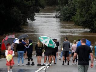
Motorists are still being advised to avoid non-essential travel in flood affected areas.
- Urgent evacuation orders have been issued for residents of Wisemans Ferry, Lower Portland and Cumberland Reach as floodwaters along the Hawkesbury move downstream and threaten low-lying homes.
- An evacuation warning has been issued for residents in Glocuester on the Mid North Coast as river levels rise there too.
- Floodwaters on the Hawkesbury peaked lower than the water during the March 2021 floods but major flooding will still expected to devastate homes and businesses in Richmond, Windsor and surrounds.
- The SES have warned residents who stayed behind in flood impacted areas of Sydney's northwest could be cut off from power, water and other utilities for "some time".
- Floodwaters have subsided on the Georges River, with residents evacuated yesterday given the all clear to go home.