
Torrential rain wreaks havoc across greater Sydney, heading south
Roads closed, flights cancelled and dams overflowing: the torrent of rain that hit Sydney on Friday morning has headed south. SEE THE LATEST.
NSW
Don't miss out on the headlines from NSW. Followed categories will be added to My News.
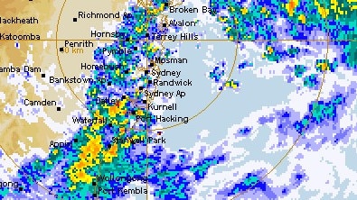
Major roads were closed, inbound and outbound flights cancelled, trains halted by flooding and dams close to overflowing as Sydney was smashed by torrential rain on Friday morning.
Scores of flights were impacted due to the inclement weather, with 18 outbound and 24 inbound flights affected, while Wakehurst Parkway was closed between Oxford Falls and North Narrabeen.
The Parramatta Ferry Wharf was inundated; floodwaters completely covering the Opal card tap-on area nearby park bins, resulting from an intense downpour along the M4 from Homebush to Parramatta, which also made for treacherous driving conditions.
At Bardwell Park and Bexley North flooding impacted the Airport and South train line, where services were stopped between Turella and Revesby.
Conditions that had been impacting the Mid North Coast headed south on Friday morning through Sydney – expecting between 35mm and 90mm on Friday – towards Wollongong, which is expected to cop between 65-95mm.
Bureau of Meteorology spokeswoman Jane Golding said more than 170mm had already fallen in Richmond in the last day, while 140mm had fallen in Newcastle with more on the way.
“Generally over the Sydney Metro area, since (9pm Thursday), we’ve seen between 60 and 100mm,” she said.
Ms Golding also warned flood-affected residents to prepare for a “major wind event” which is expected to sweep the state on Monday and Tuesday.
“It could bring gale force winds to those areas that have seen a lot of rain and what that means is that trees, power lines may be compromised.”
Since Thursday the Illawarra region has experienced heavy falls; according to the Bureau of Meteorology Dombarton, near Dapto, recorded 70mm, Bellambi’s gauge measured 38mm and further north at the Royal National Park there was 25mm.
While the heaviest falls will impact the South Coast and Illawarra throughout Friday there will soon be a reprieve for the east coast as conditions begin to clear on Friday afternoon.
Sydney Water has warned of likely overflow at Warragamba Dam, which was at 96 per cent capacity at the time of publication.
Do you know more? Message 0481 056 618 or email tips@dailytelegraph.com.au


‘Hijack’ fear: Jewish leader’s Sydney Biennale warning
A prominent Jewish leader has called on governments “not to be naive” as speculation mounts that Australia’s largest arts festival in Sydney next year will be hijacked as a platform for pro-Palestinian activism.

Shock twist: Drug pilot’s case of history repeating
A pilot jailed for flying a small plane into Australia full of drugs did the same thing a decade earlier under a different name but escaped prison because the court heard he had cancer. See the latest twist to this story.