
Wooli in erosion danger line
WOOLI residents will be warned about possible threats to the fragile peninsular section of the village as part of a Wooli Beach EASP endorsed by council.
Grafton
Don't miss out on the headlines from Grafton. Followed categories will be added to My News.
WOOLI residents will be warned about possible threats to the fragile peninsular section of the village as part of a Wooli Beach Emergency Action Sub Plan (EASP) endorsed by Clarence Valley Council last week.
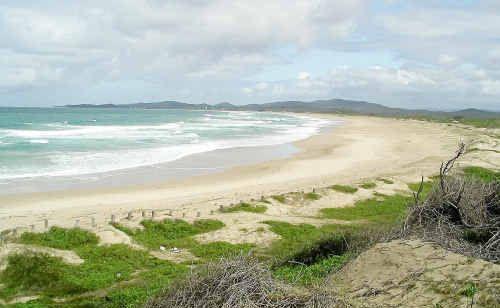
A draft of the 24-page EASP went before the council last week and includes a hybrid photo map showing the location for a possible breakthrough of the sea into the Wooli River where North St splits into Main St and Riverside Dr.
It refers to two reports which endorse the findings; firstly a 1989 Public Works study claiming that if the frontal dune of Wooli Beach were ultimately to disappear "there is potential that the ocean could breakthrough to the river during times of high seas and river flooding in the future".
Under the sub plan, a council co-ordinator will make residents aware of the Wooli hazard lines, the zone of reduced foundation capacity and where properties lie in relation to these.
The SES would be called upon to assist if Wooli came under threat from high seas and/or severe storms, the plan says.
In response to a letter from the Coastal Communities Protect Alliance Wooli Inc (CCPAW), CVC restated its position to the NSW Minister for the Environment that the emergency coastal protection works provisions enabling private property owners to defend their own properties from coastal erosion was unworkable and impractical.
Though it supported the EASP, the CCPAW called on council to change its policy on this matter to allow landholders to defend their own properties.
The plan outlines severe storm damage on Wooli Beach in 1954, 1974, 1996 and 2009 with the most recent erosion events eroding the frontal dune, leaving a high, steep escarpment along much of the beachfront.
It refers to the WorleyParsons report of 2010 which identified 44 lots in Wooli located in the zone of wave impact for a severe storm.
All of these lots were located south of the Wooli Bowling Club and some dwellings, the plan said, were landward of the immediate impact line
An additional 20 beachfront dwellings, the plan says, were located within the "zone of reduced foundation capacity" (less than 18m from the dune crest) and are susceptible to structural damage due to the reduced bearing capacity of sand in this zone.
The Wooli Beach EASP can be viewed at: http://bit.ly/AoumNC.
Information on major flooding and storm events is available to residents by phoning the SES on 132 500 number.
In the event that power and phones are out, the Wooli Post Office is the point of contact for residents, the EASP says.
Originally published as Wooli in erosion danger line
Northern Rivers council axes public access
After several motions stating local communities were being cut from a fair and democratic process, a Northern Rivers council has voted to severely limit public access and question time in its meetings.

Johns/Daley Cup: The top talking points from round 2
From attacking clinics to individual masterclasses and even more comebacks, check out the top talking points from round two of the Andrew Johns and Laurie Daley Cups.