
Wet and wild: More heavy rain, flash floods for North Coast on Tuesday
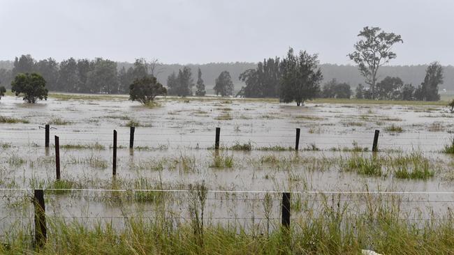
A flood watch is in place for the Clarence River as more heavy rain is predicted to fall in the catchment on Tuesday.
Grafton
Don't miss out on the headlines from Grafton. Followed categories will be added to My News.
A flood watch is in place for the Clarence River as more heavy rain is predicted to fall in the catchment on Tuesday.
Minnie Water topped the state for rainfall figures to 9am on Monday with 256mm, followed by Nambucca Heads (209mm). Elsewhere on the North Coast, Coffs Harbour had 183mm, Wooli 182mm, Woolgoolga 182mm, Grafton Airport 128mm, Yamba 115mm, Sawtell 107mm, Glenreagh 98m, Lawrence 90mm, Dorrigo 83mm and Nymboida 78mm.
Wooli had the most rain in the region from 9am to 4pm on Monday with 43mm, with significant falls also at Lawrence (40mm), Yamba (37mm), Sawtell (33mm), Glenreagh (32mm), Coffs Harbour (29mm) and Grafton Research Station (29mm).
SEE ALSO: Latest rainfall totals and river heights
Moderate flood warnings were in place on Monday for multiple rivers right along the NSW coast including the Orara, Bellinger and Nambucca rivers on the North Coast.
More than 30 roads in the Clarence Valley Council area were closed on Monday due to flooding with cautions on several others and the ferry services at Ulmarra and Lawrence out of action.
- ROAD CLOSURES: Full list of impacted roads and routes
- Tow trucks tends to 11 cars in one night from same Pacific Highway pothole
But with 90 to 150mm of rainfall predicted for Grafton, 80 to 120mm at Yamba, 50 to 80mm at Lismore, 70 to 100mm at Dorrigo and 70 to 120mm expected at Coffs Harbour, the Bureau of Meteorology has warned more rivers could be subjected to floods and an increased risk of flash flooding.
"On top of the existing flood warnings, rainfall associated with a deepening low pressure trough over western NSW has the potential to cause minor to major flooding over parts of the NSW East Coast and parts of the South West, Central West and North West," the Bureau of Meteorology warned.
"On Tuesday, as the trough reaches the Tasman Sea, a low pressure system may form, bringing increased rainfall, strong winds, damaging surf and abnormally high tides."
Several other weather warnings are in place including gale force winds for coastal areas.
- Meet the team: Daily Examiner to host free morning tea
- Exciting new digital future for The Daily Examiner
The wet weather is expected to stop abruptly from Wednesday through to at least the weekend as a drier airmass moves into the region, with maximum temperatures in Grafton rising 10 degrees from 23C on Tuesday to 33C on Wednesday.
Check out The Daily Examiner website or Facebook page for the latest updates on road closures and flood information.
Originally published as Wet and wild: More heavy rain, flash floods for Tuesday
Related Articles:
FLASH FLOODS: Big River Way closed at Grafton
Most shocking photos from NSW floods
Pictures of upper Clarence River catchment as flood watch issued
'POINTLESS': Unreadable warning signs panned

NRRRL: Top six shaken up again in wet weather footy
There has been more movement inside the top six after a couple of crucial wet-weather results in the NRRRL.
Grafton sale and auction results, week ending July 26
Grafton recorded five property sales over a million dollars last week, the latest auction and sales results reveal.