
Latest flood information for the Clarence Valley
Find out the latest road closures and flood information for the region.
Community News
Don't miss out on the headlines from Community News. Followed categories will be added to My News.
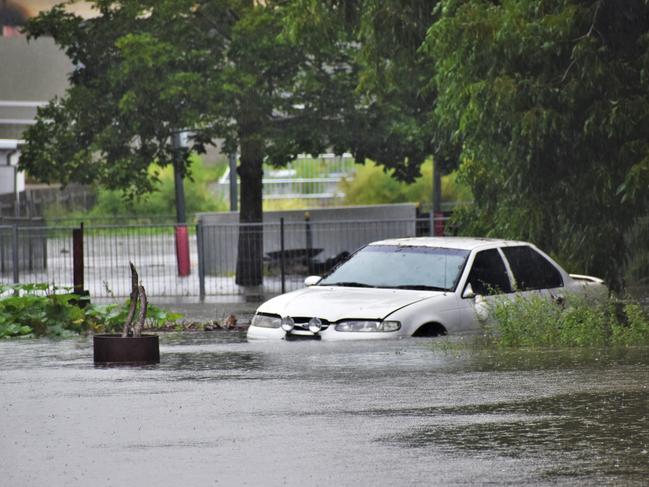
Authorities issued an evacuation order for low-lying areas of Ulmarra on Wednesday afternoon due to rising flood waters.
Residents were ordered to leave the area by 8pm Wednesday night and make their way to either friends and family, or to an evacuation centre at Maclean Showground.
The Bureau of Meteorology has this morning issued the following information:
Major flooding continues along the Clarence River at Grafton which peaked at 6.56 metres Wednesday evening with major flooding.
Major flooding is also occurring at Ulmarra which peaked at 5.13 metres late Wednesday evening with major flooding.
Major flooding is also occurring at Maclean.
Clarence River:
Major flooding is occurring along the Clarence River at Grafton, Ulmarra and Maclean.
The Clarence River at Grafton (Prince St) peaked at 6.56 metres around 08:00 pm Wednesday and is currently at 6.21 metres and falling with major flooding.
The Clarence River at Ulmarra peaked at 5.13 metres around 11:00 pm Wednesday and is currently at 5.05 metres and falling with major flooding.
The Clarence River at Maclean is likely to peak near 2.80 metres Thursday morning with major flooding.
RIVER HEIGHTS
| Nymboida River at Nymboida | 4.05 | Steady | 05:00 AM THU 25/03/21 |
| Mann River at Mitchell | 1.57 | Steady | 05:00 AM THU 25/03/21 |
| Boyd River at Broadmeadows | 3.41 | Falling | 05:00 AM THU 25/03/21 |
| Clarence River at Tabulam | 6.18 | Falling | 05:00 AM THU 25/03/21 |
| Clarence River at Baryulgil | 7.56 | Falling | 05:00 AM THU 25/03/21 |
| Mann River at Jackadgery | 5.00 | Falling | 04:00 AM THU 25/03/21 |
| Clarence River at Lilydale | 11.54 | Falling | 05:00 AM THU 25/03/21 |
| Orara River at Glenreagh (Automatic Gauge) | 3.90 | Falling | 05:00 AM THU 25/03/21 |
| Clarence River at Grafton (Prince St) | 6.21 | Steady | 05:15 AM THU 25/03/21 |
| Clarence River at Ulmarra | 5.05 | Steady | 05:15 AM THU 25/03/21 |
| Clarence River at Maclean | 2.61 | Rising | 05:15 AM THU 25/03/21 |
Flood Safety Advice:
In life threatening emergencies, call 000 (triple zero) immediately. If you require rescue, assistance to evacuate or other emergency help, ring NSW SES on 132 500.
- Avoid drowning. Stay out of rising water, seek refuge in the highest available place.
- Prevent damage to your vehicle. Move it under cover, away from areas likely to flood.
- Avoid being swept away. Stay out of fast-flowing creeks and storm drains.
- Never drive, ride or walk through flood water. Flood water can be deceptive and dangerous.
CLOSED ROADS
Braunstone Road
Byrons Lane
Cangai Bridge Road
Clarence Way at Chaselings Creek
Clarence Way at Double Swamp
Clarence Way Fine Flower
Coaldale Road
Coaldale Road at Chevalleys Bridge
Coldstream Road, Tucabia
Cordini Street Tucabia
Eatonsville Road, Eatonsville
Ewingar Road
Experiment Farm Road
Four Mile Lane
Gillets Bridge
Goodwood Island Road
Hanging Rock Road
Iluka Road at Esk River
James Creek Road
James Lane
Johnsons Lane
Kungala Road
Lawrence Road
Lawrence Road - Grafton to Lawrence
Lawrence Road - McFarlane Bridge
Lower Kangaroo Creek Road
Martins Point Road - Harwood
Martins Point Road - Watts Lane Intersection
McPhersons Crossing
McPhillips Road
Melville Street
Mulquinneys Road
North Arm Drive
Old Ferry Road, Ashby
Old Glen Innes Road
Old Glen Innes Road at Buccarumbi Bridge
Orara Way - Bluff Bridge
Orara Way at Lanitza
Plain Station Road - Yates Flat
Possum Hole Lane Ulmarra
River Street - Harwood
Rogan Bridge Road
Rushforth Road Poley Bridge
Shark Creek Road
Sherwood Creek Road
Shipmans Road
Shores Drive Yamba
Smiths Creek Road - Upper Copmanhurst
Solitude Lane
Tallawudjah Creek Road
Tucabia-Tyndale Road
Watts Lane - North Arm Drive
Watts Lane (East of Highway)
Watts Lane (West of Highway)
Winegrove Road - Lilydale Bridge
Wooli Road at White bridge
Yamba Road - Harwood Bridge
Yamba Road - Maclean Town Limit
Yamba Road at Maclean Town Limit
Yamba Road at the Palmers Channel South Bank Road Intersection
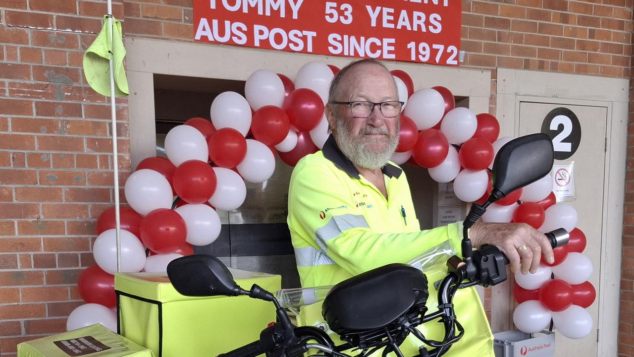
Dog attack forces NSW postie’s retirement
After five decades of delivering the post rain, hail or shine – Grafton postman Tom Harris is set to retire because of an injury from a dog attack. His final delivery is a message to dog owners.
Surfer dies after medical episode
A surfer believed to be in his late 50s has drowned off the NSW North Coast after attempts to revive him were unsuccessful. Here’s what unfolded.