
Amazing drone footage shows Grafton’s latest flood from the sky
Take a look at amazing drone footage by Grant Sparks showing the Clarence before its Grafton peak
Grafton
Don't miss out on the headlines from Grafton. Followed categories will be added to My News.
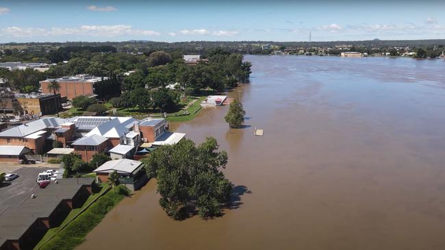
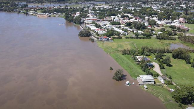
A view from the air has shown how high Grafton’s flood reached over the past days.
With the river having now peaked at just below 6.6m last night, these drone images by Grant Sparks show the water surrounding the area around the Prince Street gauge.
From the air you can see the water lapping at the levee wall of the divided town which, since its inception, has only come close in 2013 to breaching the 8.05m height.
Check out the video here:
According to the Bureau of Meteorology, the Clarence River at Grafton (Prince St) peaked at 6.56 metres around 8pm Wednesday, with major flooding. As at 9am, Grafton was at 5.99 metres and falling with major flooding.
The Clarence River at Ulmarra peaked at 5.13 metres around 11pm Wednesday with major flooding. At 9am, it was at 4.94 metres and falling with major flooding.
The Clarence River at Maclean is expected to peak near 2.80 metres late Thursday morning, with major flooding.

Cops allegedly uncover ‘white crystal substance’, plants in raid
Two men have been hit with multiple charges after a police raid on a Grafton property allegedly uncovered more than 70 cannabis plants, a firearm and a suspected stolen vehicle. Here’s the details.
Read more

Group 2: Woolgoolga, Sawtell set up heavyweight clash after big wins
Two of Group 2’s heavyweight teams have set up a blockbuster encounter after Woolgoolga secured the minor premiership and Sawtell turned in its best defensive effort of the season.
Read more