‘Severe impacts’: Cyclone likely to impact Queensland next week
Australia’s eastern coastline is being urged to prepares a cyclone looms with “multiple scenarios” involving “severe impacts”.

Environment
Don't miss out on the headlines from Environment. Followed categories will be added to My News.
Australia’s eastern coastline is being urged to prepare for severe weather impacts as a potential tropical cyclone looms.
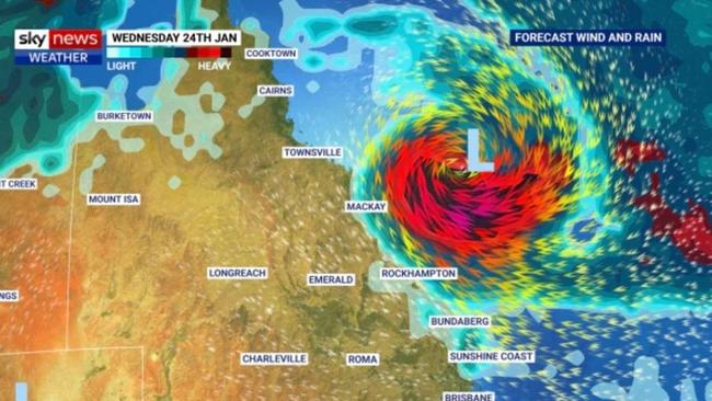
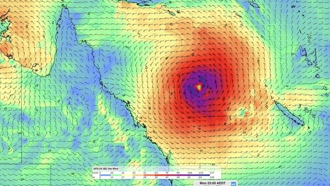
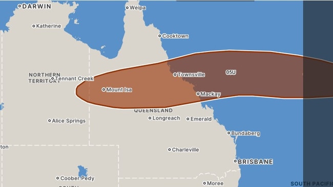
The Bureau of Meteorology expects a tropical low, identified as 05U and currently situated over the Coral Sea, to develop into a tropical cyclone by Monday.
Communities spanning the entire east coast of Queensland are urged to stay vigilant and updated with forecasts and weather warnings, as the Bureau anticipates “multiple scenarios” involving “severe impacts”.

The BoM’s Morgan Pumpa said there was uncertainty surrounding the system’s intensity, and said it was important to keep abreast of forecasts and alerts.
“There’s not much confidence in the positioning or movement in the system. At the start of next week, we could be seeing some impacts to the Queensland coast,” she told the Courier Mail.
The latest seven day forecast map shows the system could cross the coast somewhere between Rockhampton and Cairns, an area which includes regional cities Townsville and Mackay, on Wednesday or Thursday next week.

She highlighted the significance of the current trough moving over southern Queensland and the extensive monsoon trough over the northern tropics.
The monsoon, stretching across the northern breadth of the state and the Coral Sea, is expected to persist for several days, bringing heavy rainfall, storms, flooding, and abnormally high tides to the Gulf and Torres Strait.
The Bureau predicts that sea levels will exceed the year’s highest tide.
“People need to be alert not only in the north but also in the south, with those two systems bringing the chance of some heavy rainfall, which could lead to flash flooding,” warned Ms Pumpa.
She added: “Rain in both the north and south may lead to river rises.”
While a flood watch is in effect for the Cape York Peninsula and parts of the Gulf of Carpentaria, Ms Pumpa said the existing monsoon conditions would likely not overlap with the impacts from tropical low 05U.

She explained: “We have a little bit of a buffer between the two. In the meantime, it is really important to keep an eye on the warnings while we monitor possible movement of the tropical low 05U.”
Flood warnings are currently issued for various rivers and catchments, including the Tully and Murray Rivers, Herbert River, Paroo River, Barcoo River, Bulloo River, Diamantina River, and Warrill Creek.
Adding to the meteorological concerns, Tropical Cyclone Anggrek, currently a category one system, is positioned west of the Cocos (Keeling) Islands, an Australian territory.

The system is expected to pass west of the islands on Friday, tracking southwest.
BOM predicts that TC Anggrek will continue moving slowly westward at tropical cyclone intensity, though a potential eastward movement might weaken into a tropical low.
Meanwhile, another tropical low, situated over the Northern Territory, is expected to remain landlocked for the rest of the week, likely drifting over the NT between now and Sunday before tracking over Western Australia early next week.
This low is anticipated to cause persistent monsoon rain and thunderstorms over parts of the NT and WA, increasing the risk of flooding.
While there’s a chance the low could drift off the northern coast of WA next week, the likelihood of it becoming a tropical cyclone in WA waters remains low.
Originally published as ‘Severe impacts’: Cyclone likely to impact Queensland next week


