
‘Severe weather impacts’: Entire Qld coast on high alert as cyclone looms
A massive stretch of the state has been warned to start getting ready for another cyclone, as the weather bureau reveals two competing weather systems will determine if and where the system will hit.
QLD weather news
Don't miss out on the headlines from QLD weather news. Followed categories will be added to My News.
As Premier Steven Miles issues a warning to Queenslanders along the coast to prepare for a potential Tropical Cyclone to hit mid-next week, the weather bureau says two competing weather systems will determine if and where a tropical cyclone will hit.
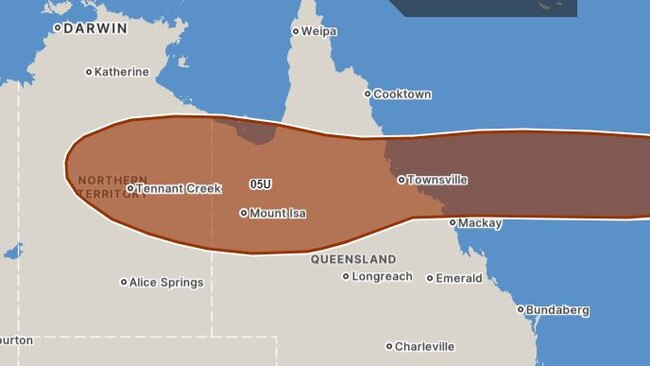
Senior meteorologist Daniel Hayes said there were “quite a few influences” that will determine the outcome of tropical lo 05U - soon to be tropical cyclone Kirrily - including an upper level trough developing over the Tasman Sea and the low currently sitting over the Northern Territory.
Mr Hayes said 05U would likely develop into “quite a strong cyclone” but where it ended up depended on which system became more dominant in coming days.
“The movement of the low over the NT will have impact on an upper ridge across Australia pulling it (05U) in, while the upper level low pushing through the Tasman Sea could get underneath it and push it away from the Queensland coast,” he said.
“It could get captured by that Tasman trough and taken out to sea … which would be preferred.
“It all very much depends on those steering influences and which one becomes the dominant one.”
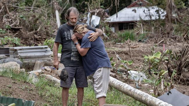
Should 05U make landfall, there is a high chance it will impact areas affected by Ex-Tropical Cyclone Jasper last month.
“It’s possible it could cross where Jasper did,” Mr Hayes said.
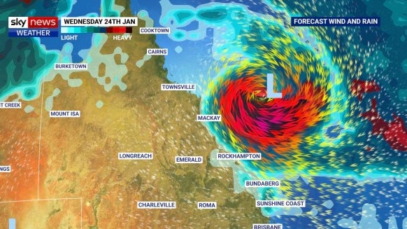
“There is a wide area where, if it did made a crossing at this point, it could come ashore between the upper north tropical coast down to around central coast, Capricornia area.
“Basically Cairns down to Rockhampton.”
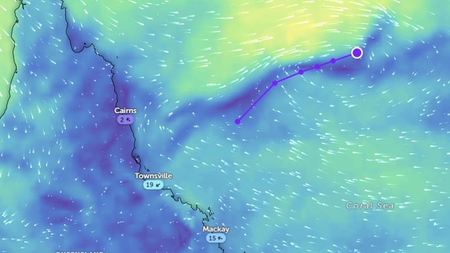
There is now a 75 per cent chance tropical low 05U, currently sitting over the Coral Sea, will develop into a cyclone by Monday.
The low is expected to then slowly track south between Sunday and Tuesday, potentially towards the Queensland coast.
Mr Miles said the latest advice from the Bureau of Meteorology was that the system would develop into a Tropical Cyclone.
“There’s a high level of confidence in that prediction,” he said.
“However, there is a range of possibilities with regards to where it may travel.
“It could head towards the Queensland coast, possibly around Townsville, but also possibly as far south as Rockhampton, or alternatively, it could head towards New Caledonia.”
Mr Miles said now was a “good time” for Queenslanders along those parts of the coast to prepare.
“We’ll be ramping up our ‘get ready Queensland’ messaging,” he said.
“The Bureau expects that they would be able to issue a track map over the weekend, possibly late on Sunday.”
Meanwhile, a strong monsoon trough remains active in the Far North, delivering more than 100mm of rainfall to the Daintree area over the past 24 hours.
Mr Hayes said heavy falls were expected to continue today, but the monsoon could weaken when the tropical cyclone Kirrily develops.
“The good news is once the cyclone develops, as it intensifies we’ll see an increase in southerly flow, contracting the monsoon north and taking it away from those areas,” he said.
“Further up the Peninsula at least.
“This is quite common for Queensland though, we can have a significant cyclone developing offshore and this nice weather, a nice breeze before it suddenly makes impact.
“At least it will give (the north) a few days of reprieve before we start seeing what happens with the low or cyclone.”
In the meantime, almost the entire state is being warned to expect possible severe thunderstorms on Friday, with a large chunk of the southeast facing the worst of the conditions.
⛈ï¸QLD Storm Forecast for Fri 19/1. Severe storms with heavy to locally intense rainfall likely in inland SEQ and the Wide Bay & Burnett, this could lead to dangerous flash flooding. Heavy rain with storms is possible in parts of southern, central, western and FNQ again today. pic.twitter.com/fGQywrYFjm
— Bureau of Meteorology, Queensland (@BOM_Qld) January 18, 2024
The Darling Downs and Granite Belt are facing likely severe thunderstorms, while all but the very southwest corner of the state could be impacted by some sort of storm activity.
As the potential cyclone threat builds, communities along the entire east coast have been urged to stay up to date with forecasts and weather warnings, with the Bureau expecting “multiple scenarios” involving “severe impacts”.
Community Information Officer Morgan Pumpa said there was still high levels of uncertainty on how intense the system could be, and it was imperative Queenslanders stayed up to date with forecasts and alerts.
“There’s not much confidence in the positioning or movement in the system,” she said.
“At the start of next week, we could be seeing some impacts to the Queensland coast.”
Ms Pumpa stressed the current trough moving over southern Queensland and the large monsoon trough sitting over the northern tropics were also of significance.
The monsoon extending over the northern breadth of the state and the Coral Sea will persist for several days, bringing heavy rainfall, storms, localised flooding and abnormally high tides to The Gulf and Torres Strait for several days, with the Bureau predicting sea levels to exceed the highest tide of the year.
“People need to be alert not only in the north, but as well in the south, with those two systems bringing the chance of some heavy rainfall which could lead to flash flooding,” she said.
“Rain in both the north and south may lead to river rises.”
A flood watch remains current for the Cape York Peninsula and parts of The Gulf of Carpentaria where the potential tropical cyclone is forecast to make impact.
But Ms Pumpa said the two existing systems would most likely not overlap with any impacts from tropical low 05U, with the monsoon conditions expected to begin easing at the beginning of next week while 05U remains out at sea.
“We have a little bit of a buffer between the two,” she said.
“In the meantime, it is really important to keep and eye on the warnings while we monitor possible movement of the tropical low 05U.”
Flood warnings are current for the Tully and Murray Rivers, Herbert River, Paroo River, Barcoo River, Bulloo River, Diamantina River, and Warrill Creek catchments.
Shower and storm activity are forecast to persist into the weekend, with muggy conditions to last in the South East for the next six to seven days.

Monster weather system brings storm, heavy rain to Qld
Brisbane and surrounding parts of the southeast have been hit by storms and heavy rainfall this afternoon as a 3000km-long monster low moves across the state.

Wild storms, polar blast as 3000km monster low barrels towards Qld
The system, which stretches 3000km from north to south and encompasses 30 per cent of Australia, is forecast to pack a punch when it hits Queensland.