
Cold outbreak brings temperatures not seen in decades to major cities
Three cities are in for colder weather than has been seen at this time of year for decades. Even the Top End will be affected by the cold outbreak.
Environment
Don't miss out on the headlines from Environment. Followed categories will be added to My News.
A huge cold outbreak will affect all major Australian cities except Perth over the next week, with temperatures not seen so low this early in the year in decades.
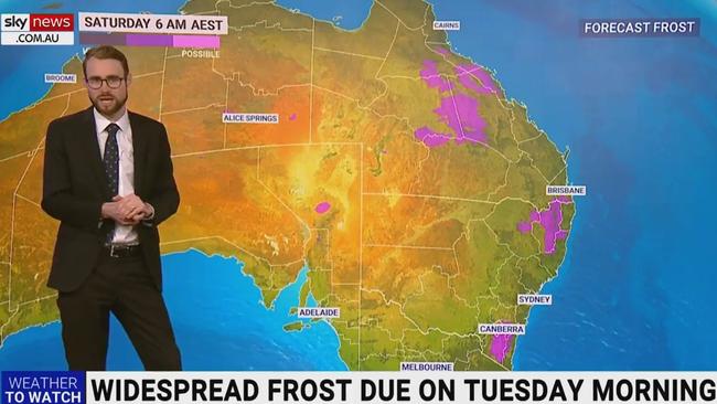
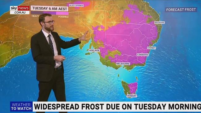
Widespread severe frost is expected to hit large parts of the nation from early next week — with temperatures reaching below 5C for much of the south-east.
Temperatures in Brisbane are forecast to drop to just 6C on Friday. The city has not seen a week so cold this time of year since 1904, according to Weatherzone.
Melbourne is looking at its coldest week this early in the season since 1982 and Sydney since 1989.
By Thursday, even Cairns and Darwin will be “notably cooler”, according to Sky Weather meteorologist Rob Sharpe.
“The humidity will be sapped out of the air by the dry southerlys, with the coldest weather due on Friday and coldest morning on Saturday,” he said.
Patchy frost, primarily on the NSW slopes and ranges, is expected Thursday morning.
It will continue into Friday and Saturday morning, also affecting Queensland.
Mr Sharpe said there was even the chance of frost up into the Atherton Tablelands in Far North Queensland.
On Monday and Tuesday, the frost will become much more widespread through the southeast.
Brisbane
According to the forecast, day time temperatures in Brisbane will not get above 18C and 19C all week, until Tuesday when it will be a top of 20C.
Temperatures will drop as low as 6C and 7C over the next few days.
Bureau of Meteorology meteorologist Helen Reid said icy temperatures were typically reserved for later in the month, labelling the cold snap “well below the June average”.
“It‘s usually the last week of June that we get temperatures as cold as this, so it’s unusual to have it this cold at the start of June,” she said.
Winter is already present in southern Queensland. This week cool, dry air will make its way across the north of #QLDweather. Temperatures will be well below average for daytime and overnight. Frosty conditions expected for the southern interior. Details https://t.co/8QnIc7aRJZpic.twitter.com/s10Z2pMrZe
— Bureau of Meteorology, Queensland (@BOM_Qld) June 7, 2022
Queenslanders complaining of feeling colder than the temperature predictions are right, with a lack of humidity driving “that feeling that takes your breath away”.
“That dryness is adding to that sense of extra chill,” Ms Reid said.
Sydney
Mr Sharpe said while the temperature on Wednesday in Sydney was lower than it was the day before, it was likely to feel quite similar because it was not as windy.
Day time temperatures are forecast to reach a top of just 15C or 16C all week.
The lowest temperatures will be 7C and 8C.
“We haven’t seen anything like this, this early in the year since 1989 – 32 years ago,” Mr Sharpe said.
Melbourne
Melbourne will be slightly colder with day time temperatures ranging between 11C and 14C, with the warmest day being Friday.
It will drop to a low of just 6C on Tuesday.
Canberra
The capital city see temperatures drop to -2C on Monday and -4C on Tuesday.
Day time temperatures won’t be any warmer than 10C or 11C all week.
Hobart
It is a wet and windy week for Hobart.
There is even a chance of snow in the city late Saturday and early Sunday thanks to a “particularly cold” air mass.
Temperatures will drop to just 2C on Sunday. The warmest day will be Tuesday with a top of 11C.
Mr Sharpe said the windy weather was expected to calm down early next week with Saturday being the windiest day.
Here's the latest low down on the snow down, which will mostly be thru western, central and southern #Tas though bursts of showers into the northeast at times during the week. Snow rising to 1000m this avo, lowering to 700-800m Thurs, 600m Friday, 200m Sat night and early Sun.
— Bureau of Meteorology, Tasmania (@BOM_Tas) June 7, 2022
Adelaide
It is forecast to get no warmer than 15C for the rest of the week in Adelaide.
Wednesday will have a low of just 5C, and Monday and Tuesday are looking at a low of 6C.
“For the next few days showers are a little bit more likely (than Wednesday) but it’s going to be nothing like what we saw during the last week,” Mr Sharpe said.
Darwin
The Top End is also being affected by the cool change.
Darwin will get to down to 19C on Saturday and there will be “much less” humidity.
Day time temperatures will still be in the low 30s.
Perth
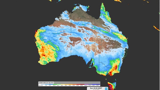
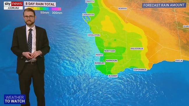
While it is not getting a cold snap, the west coast city will be hit by wet weather, with showers developing Wednesday evening.
“After that, it’s barely going to stop,” Mr Sharpe said. “We will see the wet weather coming and going right across the coming week.”
More than 50mm of rain is expected over the next eight days.
Perth will see a low of 11C for most of the week.
Day time temperatures will reach 23C on Thursday, the city’s warmest day, and the coldest will be Tuesday with a top of 20C.

Originally published as Cold outbreak brings temperatures not seen in decades to major cities

200 species dead in ‘unprecedented’ disaster
Scientists have offered a grim outlook for Aussies hoping for an immediate solution to an ‘unprecedented’ disaster leaving the water at Aussie beaches toxic.

Australia told to brace for a soaking
Parts of Australia that have already experienced a wet weekend should expect more downpours in the week ahead.