
Bureau of Meteorology issues severe thunderstorm warnings for Darling Downs, Maranoa and Warrego
The Bureau of Meteorology has warned that parts of the Darling Downs could experience hail and localised rainfalls with damaging winds expected to hit the southwest region in the coming days.
Regional News
Don't miss out on the headlines from Regional News. Followed categories will be added to My News.
Residents across southwest Queensland are being warned to remain vigilant with severe thunderstorms expected to sweep the region in the lead up to the weekend.
The Bureau of Meteorology issued several thunderstorm warnings across the Darling Downs on Wednesday night with Crows Nest, Yarraman, Imbil and Nanango particularly susceptible to large hailstones, heavy rainfall and flash flooding.
Meteorologist Kimba Wong said parts of the region north of Toowoomba could expect localised rainfalls as high as 30mm.
“There’s a few storms, mainly across the mountainous terrain of the Dividing Range,” Ms Wong said.
She confirmed at this stage the storm is not expected to come down as far south as Toowoomba, however further west places including Chinchilla could see some storm activity.
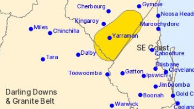
“Chinchilla certainly may see some storm activity, not as far south as Goondiwindi, it will mainly stick to the Carnarvon ranges.
“There might be some isolated storm activity further west of the Toowoomba ranges and out towards the Northern Territory.
“Most locations it will be pretty much nothing.”
On Thursday morning, a vigorous cold front is forecast to enter southwestern Queensland, with strong gusty winds expected to stretch out west across the state to the Northern Territory border.
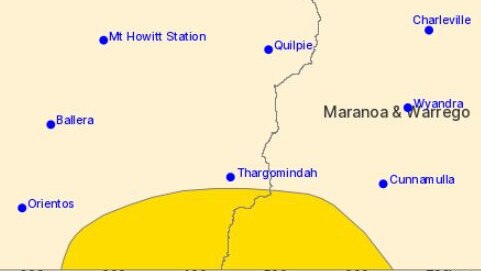
Parts of the Channel Country and Maranoa and Warrego districts are asked to remain on high alert as damaging winds could impact trees, powerlines and see lots of dust in the air.
Conditions will ease overnight as the system tracks southeast out of Queensland on Friday.
“It’s mostly just damaging wind gusts with those storms,” Ms Wong said.
“There’s very windy conditions through the atmosphere. Any storms that tap into that could be very gusty.
“Come Saturday a much cooler and stable air mass will come through.
“More wintery conditions and clearer nights are expected.
“Given the windy condition tomorrow across the southwest there could be some raised dusts, (with wind) picking dust up off the ground.”
BoM weather warnings are also available through TV and Radio broadcasts, the Bureau’s website at www.bom.gov.au or call 1300 659 210.


Wally Lewis ties knot in secret ceremony
Rugby league Immortal Wally “The King” Lewis has married his long-time partner Lynda Adams in a secret ceremony at Kangaroo Point in Brisbane today with no expense spared.

Young mum’s ‘ultimate sacrifice’ revealed after sudden death
The sister-in-law of a 32-year-old Qld woman, whose Lupus-linked death has shocked her small hometown has led tributes to the much-loved mum of two young children who put her family above her chronic health battle.