
Will Tropical Cyclone Alfred hit Qld? Everything we know right now
Most weather models are in agreement that Tropical Cyclone Alfred is on a collision course with a highly populated stretch of the Queensland coast. EVERYTHING WE KNOW

QLD weather news
Don't miss out on the headlines from QLD weather news. Followed categories will be added to My News.
Tropical Cyclone Alfred is a high probability of crossing one of the most highly populated stretches of the Queensland coast by early next week.
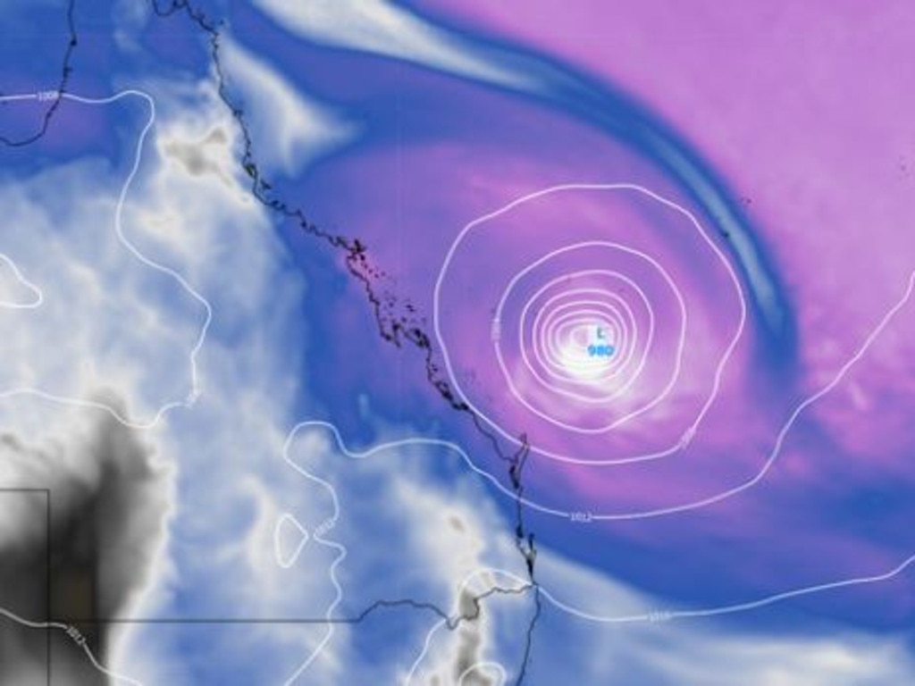
The Bureau of Meteorology said that at 10pm on Wednesday the category-three cyclone was about 870km northeast of Mackay and 990km north northeast of Rockhampton, slowly moving south.
Most weather models are in agreement Alfred will turn towards Queensland this weekend.
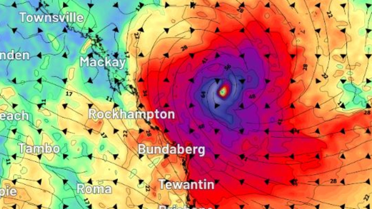
It is predicted to cross somewhere between Brisbane and Townsville, with a direct hit on Mackay, Rockhampton, Hervey Bay, Bundaberg, Gladstone or the Sunshine Coast a possibility.
On Tuesday, Alfred was upgraded to a category two system as it sat 1000km northeast of Townsville.
The Bureau of Meteorology, despite its forecast tracking only extending four days, is already concerned, warning of the potential for “significant impacts” on the Queensland coast.
Weather bureau senior meteorologist Dean Narramore said earlier on Wednesday: “We are expecting to see the slow moving continue today, as it generally takes a southward direction later today and into tonight, and then that is going to continue to remain well off the Queensland coast, and we could see it intensify into a category three system tonight into Thursday morning.
Mr Narramore said impacts are starting to be felt by coastal communities and offshore islands.
“The only impacts we’re seeing are for our coastal communities and offshore islands, we’ve got instant, fresh and gusty south easterly winds, and we do have strong wind warnings current for many of our coastal waters,” he said.
Mr Narramore added that the bureau is monitoring the cyclone and several scenarios, with some indicating it will move closer towards the Queensland coast.
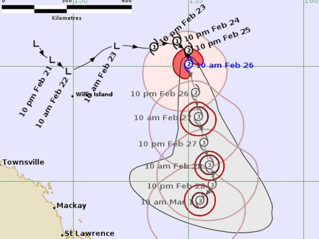
“We’re expecting TC Alfred to continue that southerly track as we move through Thursday and Friday, and then as we get into the weekend, there’s a range of scenarios on exactly where it will tend.
“Some of those scenarios have it heading closer towards the Queensland coast, so towards the weekend and early next week, but still keeping it offshore, but it does get pretty close.
“Other scenarios continue that southerly track, well off the Queensland coast, and there’s also a few other scenarios that have it heading further south east, further away from the Queensland coast.”
WHAT THE MODELS ARE SHOWING
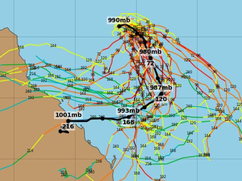
One forecast model, a GFS ensemble shown below, has Tropical Cyclone Alfred tracking west this weekend and most likely impacting Central Queensland.
Landfall is predicted by Tuesday next week at the earliest.
Meanwhile, predictions by the European Centre for Medium-Range Weather Forecasts (ECMWF) model – one of the best forecast models in the world – has the cyclone’s impact zone ranging from Townsville to Bundaberg, as shown below.
It is predicted to make landfall by Sunday.
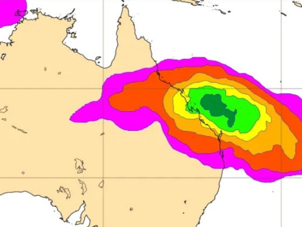
Despite these two models having the cyclone making landfall, there are still forecasts that keep Alfred off the coast.
WHY THERE IS SO MUCH UNCERTAINTY
Will it, won’t it? That’s the question surrounding much of Queensland’s coastline with the threat of Tropical Cyclone Alfred and whether it will hit.
The Bureau of Meteorology’s latest update said the system remained a category two cyclone and was about 970km northeast of Mackay and about 1030km east-northeast of Townsville.
Weatherzone’s Ben Domensino said Alfred, which has wind speeds of 97km/h in its core, was expected to intensify into a category three system either today or tomorrow.
However, Mr Domensino said there was increasing uncertainty surrounding Alfred’s strength and movement beyond Thursday.
“Some forecast models suggest that Alfred may track towards the west and get closer to the Queensland coast from the weekend into next week,” he said.
“Other models keep the system offshore. Most forecast models also expect Alfred to weaken from Friday or the weekend as it moves into a less favourable environment.
“At this stage, it’s not possible to know if Alfred will track over the Queensland coast next week and if it does, whether it will be a tropical cyclone or a weaker low pressure system.”
Mr Domensino said the uncertainty made it difficult to predict TC Alfred’s impact on Queensland.
He said powerful waves would be the most likely threat.
“At this stage, anyone living in eastern Queensland, or even northeast NSW, should keep a close eye on the latest tropical cyclone track maps and their local forecasts and warnings,” he said.
The Bureau’s senior meteorologist Dean Narramore on Tuesday afternoon said there was a wide range of possible scenarios for Alfred’s future tracking.
“Some of our scenarios do have the cyclone tracking further to the west, closer to the Queensland coast, while other scenarios continue to a south and even eventually south-easterly track as it moves further away from the Queensland coast,” he said.
“And then it becomes important to see where it will track as we move into the latter part of the week and into the weekend.”
WHY IS IT NAMED ALFRED?
The Bureau of Meteorology selects names for cyclones from a pre-determined list of names in alphabetical order, switching between male and female names.
Following Tropical Cyclone Zelia, the next name on the list was meant to be Anthony, however the weather bureau removed Anthony from the list, due to it being the first name of Prime Minister Anthony Albanese.
“When a name matches a prominent person of the time, we reorder to the next name starting with that same letter to avoid any confusion,” a Bureau spokesperson said.


Ice ice baby: Spectacular images of unseasonal frost as Qld freezes
Queensland’s overnight temperatures will increase to double digits in the coming days, following the coldest start to winter in 16 years, bringing frost and ice to many regions. SEE THE PHOTOS

City’s coldest June start in 16 years, feels like MINUS 9.8C out west
Southeast Queensland is shivering through its coldest morning in more than 15 years but feels-like temperatures have dropped to insane levels in the southern inland.