
Tropical Cyclone Alfred latest: System intensifying, as path shows it heading towards Qld coast
Tropical Cyclone Alfred is slowly intensifying and is set to become a category three system possibly today with a risk it will move towards the Qld coast in coming days. See the latest mapping.
Tropical Cyclone Alfred is slowly intensifying and its path is highly uncertain with a risk it will move towards the Queensland coast in coming days.The cyclone is still set to remain well off the Queensland coast until at least later in the week, the Bureau of Meteorology says, with the the potential to have “significant impacts” on the Queensland coast.
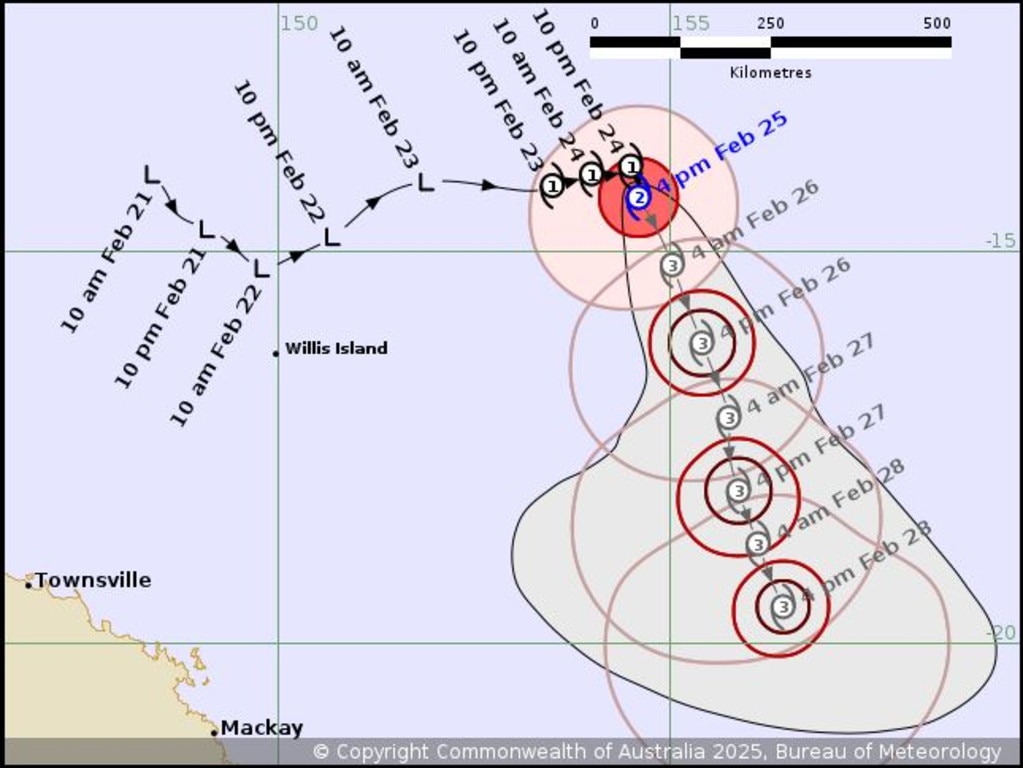
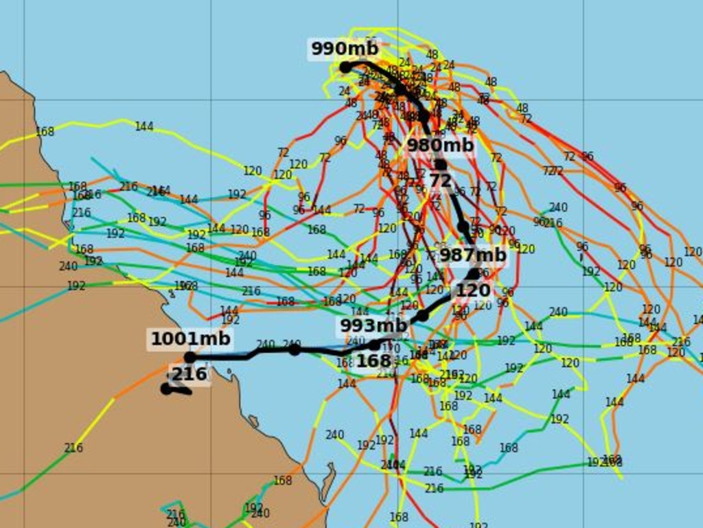
The bureau’s latest update said the system remained a category two cyclone and was about 970km northeast of Mackay and about 1030km east-northeast of Townsville.
It was expected to intensify into a category three system overnight.
It was slow moving, but was forecast to begin moving in a general southward direction from Thursday.
“There is high confidence that Alfred will remain well off the Queensland coast until at least late in the week,” the bureau said.
“Beyond that, the track becomes highly uncertain and there is a risk it will move closer to the central Queensland coast over the weekend.”
Senior meteorologist Dean Narramore said on Tuesday afternoon there was a wide range of possible scenarios for Alfred’s future tracking.
“Some of our scenarios do have the cyclone tracking further to the west, closer to the Queensland coast, while other scenarios continue to a south and even eventually south-easterly track as it moves further away from the Queensland coast,” he said.
“And then it becomes important to see where it will track as we move into the latter part of the week and into the weekend.”
Mr Narramore earlier said Alfred was expected to intensify into a category three by Wednesday, although the BOM’s 10am update predicts the system would be a category three by 10pm on Tuesday.
“As it moves through today and tonight, we expect it to slowly, very slowly, move towards the southeast and slowly intensify as well,” he said on Tuesday morning.
“We’re expecting it to intensify into a category three system … and continue as a category three system through Thursday and Friday as it continues to track further away from the Queensland coast.
Sky News Weather Meteorologist Rob Sharpe said there were concerns for Alfred’s potential impact on the coast.
“This weekend, it’s a slight chance to make its way to the Queensland coastline,” he said.
“It’s a system we’ll have to watch because we have got that potential to have significant impacts on Queensland or New South Wales at some time in the next two weeks.”
The bureau’s latest seven-day forecast says there was “large uncertainty” in Alfred’s track beyond Thursday.
“It could come towards the coast as we move into the late week and into the weekend, but listen, the short term for the rest of the week, we’re likely to see TC Alfred continue to move slowly south, well off the Queensland coast.”
While it could hit land in the future, Alfred is currently “contracting” all severe weather off the Queensland coast, Mr Narramore said.
“We might see some isolated coastal showers and some gusty winds about the Queensland coast, but generally it’s going to be a fairly dry, cool-to-mild and sunny week,” he said.
“The bureau said Alfred was forecast to turn southeast and then south on Tuesday, while continuing to intensify through to the middle of the week.
“There is high confidence that Alfred will remain well off the Queensland coast until at least late in the week,” the alert said.
“Beyond that, the track becomes highly uncertain and there is a risk it will move closer to the Central Queensland coast over the weekend.”
Mr Sharpe said Australia is currently in its fourth La Nina of the past five years, a weather pattern that brings increased rainfall.
Higgins Storm Chasing predicted the Alfred has been slow moving but has some forward speed that could see it head south in the next few days.
“This is technically bringing the system closer to Central and South East Queensland, with a turn towards the southwest possible later in the week,” Higgins said.
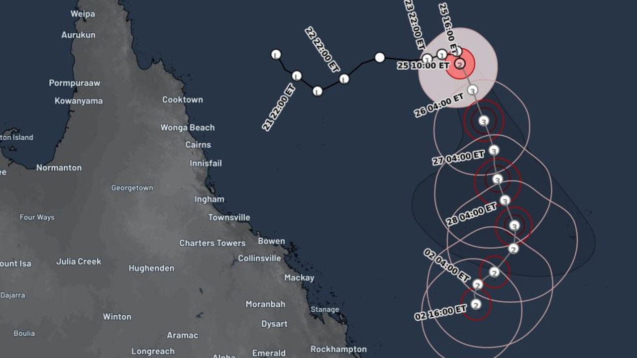
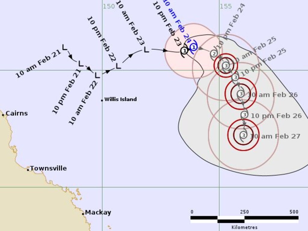
Updated bureau modelling released on Monday afternoon showed Cyclone Alfred was forecast to hit coastal areas of central Queensland next Monday night. This includes Mackay, Hamilton Island, Prosperine, Hideaway Bay, Airlie Beach, Midge Point and Byfield.
Yesterday, senior meteorologist Angus Hines said Alfred has not moved far since Sunday when it was named a tropical cyclone.
“Then we’ll continue to see intensification tomorrow, on Tuesday, where we could see a category 3 tropical cyclone,” he said.
“That’s classified as a severe tropical cyclone at that point, meaning the winds are absolutely racing around the centre.”
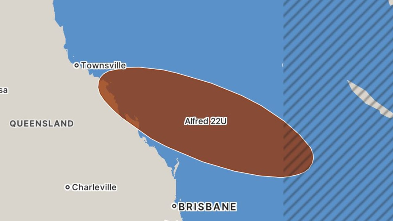
Mr Hines said the cyclone would stay at least 700km offshore over the next few days.
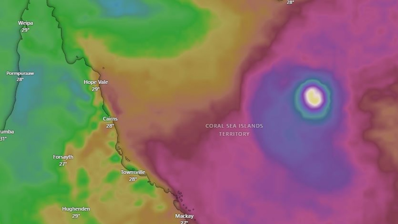
“Those strongest winds and mist of the rainfall will be out over the open water of the Coral Sea, but it will still be influencing the coastline,” he said.
Mr Hines also said there could be scenarios of the cyclone veers closer to the Queensland coast late this week.
“It could approach or even cross the coast anywhere from around the Herbert and Lower Burdekin, down to the Wide Bay or potentially even further south,” he said.
By 11am on Monday, it was about 495km east-northeast of Willis Island, 930km east-northeast of Cairns and continuing to gain strength as it headed east at a speed of 7km/h.
Mr Hines said as the week progresses, the cyclone will intensify, and possibly veer back towards the central or southern Queensland coast.
This intensification “would greatly increase the risk of severe weather”, although it’s too early to say exactly where would be impacted, how strong the winds would be, or how much rain Queenslanders can expect, Mr Hines said.
Modelling shows Alfred could make a turn to the southwest and begin heading back to the Queensland coast, with the area between Townsville and Bundaberg in its path.
Mr Hines said despite being close to 1000km off the coast, Alfred is still influencing Queensland’s weather.
“Coastal parts of Queensland will get a breezy week, with some south-easterly winds, as well as a few passing showers,” Mr Hines said.
“Strong winds will make for choppy conditions, as well as sizeable swell over the Queensland coastal waters throughout the week.”
Mr Hines encouraged people to check the Bureau of Meteorology’s cyclone tracker map throughout the week, as forecasts would become clearer in the coming days.


