
What caused waterspouts over Moreton Bay as 250mm falls across South East Qld
Incredible rainfall totals of almost 250mm and 100,000 lightning strikes have been recorded across South East Qld amid severe storms following a spectacular waterspout display over Moreton Bay.

QLD weather news
Don't miss out on the headlines from QLD weather news. Followed categories will be added to My News.
Almost 250mm of rain has fallen in parts of South East Queensland as weather experts reveal what caused the spectacular display of waterspouts over Moreton Bay on Monday.
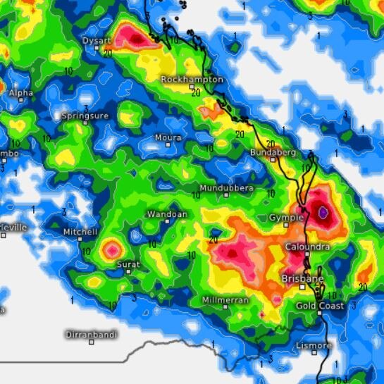
Heavy rain has being falling across the southeast in the past 36 hours, with the highest totals recorded at Poona Dam on the Sunshine Coast, with 245mm since 9am Monday, Mapleton (214mm), West Woombye (212mm), Eerwah Vale (201mm) and Maroochydore (199mm).
In the Moreton Bay region just north of Brisbane 139mm fell at Ocean View, 111mm at Upper Caboolture and 105mm at Morayfield.
The Bureau of Meteorology’s Angus Hines said rainfall totals were “wildly inconsistent”, with the heaviest falls associated with isolated severe thunderstorms.
The Sunshine Coast was hammered with more than 200mm of rain in some areas last night as over 100,000 lightning strikes hit the state but Bureau of Meteorology said the worst had passed.
Senior meteorologist Angus Hines said the most significant rainfall was seen slightly inland from the coast.
“Near the water at the airport, we’ve only seen about 16mm of rain … the much more significant and heavier falls associated with thunderstorms with just a little bit away from the coast and we saw up to 245mm as the top observation,” he said.
“West Woombye had 218mm and Mapleton 216mm of rain … the fact that we’ve seen those wildly inconsistent rainfall totals over 200mm, far away from places saying 5-15mm in the same time period is really characteristic of thunderstorms and severe storms.”
Mr Hines said while these storms can likely cause flash flooding there hasn’t been any major concern for riverine flooding.
“[The rain] didn’t follow the nature of widespread falls to really make the river levels shoot up too quickly,” he said.
“[It’s] likely that there was some flash flooding … we may we may yet see some of the impacts come through.”
Southeast Queensland can expect light rainfall today with one thunderstorm still set to pass through.
Mr Hines said South East Queensland could expect some showers today with a chance of thunderstorms on the Sunshine Coast.
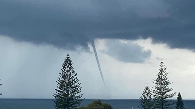
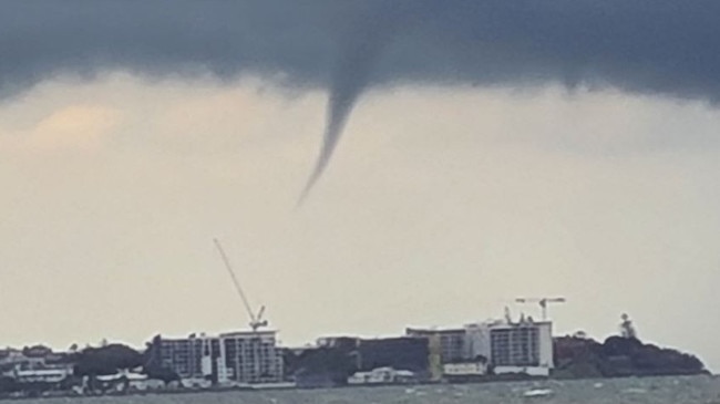
It comes after a spectacular and rare display over waterspouts over Moreton Bay on Monday, which the Bureau of Meteorology say was caused by a combination of perfect conditions.
“The interesting thing in this situation is it looks like it formed along a south easterly wind surge so it was pushing northwards through Redcliffe around the time the photo was taken,” Mr Claassen said.
“Basically that south easterly wind surge would mean – so there were some storms that formed at Redcliffe – as that column of air is rising towards the storm it’s rotating thanks to that south easterly wind surge.
It’s a very moist environment which encourages them to form so it’s essentially just a small rotating column of air that was rising to touch the water of the thunderstorm.
“Typically it has very limited impact, it’s quite transitory so they might only last for a short period of time before weakening.
WHAT IS A WATERSPOUT?
A waterspout is a spinning column of air that sucks up water (usually from the ocean) to make a twisting funnel of water and cloud connecting the sea and the sky.
They are spectacular but short lived, usually lasting no more than 5 minutes (but occasionally up to 10 minutes). Winds inside the waterspout can be faster than 100kmh, and they can do great damage to boats at sea.
HOW DO WATERSPOUTS FORM?
Waterspouts can form when winds blowing in two different directions run into each other.
The collision of the two winds makes air move upwards because it has nowhere else to go. This rising air carries water vapour high into the sky where it creates rain showers, storms and cumulus clouds.
As the air rises, it can tilt some of the horizontal spinning air near the surface into the vertical direction. When this vertical spin concentrates at a particular point it starts sucking up water — and you have yourself a waterspout.
WHEN AND WHERE ARE WATERSPOUTS MOST COMMON?
In Australia, waterspouts are most common along the NSW and Queensland coast.
Most mornings, cooler night-time air blowing off the land meets warmer air sitting out to sea. Usually this results in a line of clouds sitting offshore where the 2 air masses meet.

Storm shield: How AI will protect our state of disaster
Queensland has secured world-first AI storm detection technology in a $3m partnership between Suncorp and the state government to revolutionise natural disaster response.

Hail, rain, wind, SNOW: Winter storm on Qld collision course
A rare winter storm threatens to dump 15cm of snow on Queensland's Granite Belt this weekend as forecasters warn of an incoming polar air mass.