
Southeast Queensland to be smashed by 200mm rain, severe storms, king tides and huge swells
More than 60mm of rain has fallen in just an hour as a significant deluge reaches southeast Queensland, but forecasters warn this is just a taste of what’s still to come overnight.
QLD weather news
Don't miss out on the headlines from QLD weather news. Followed categories will be added to My News.
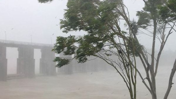
The Bureau of Meteorology is warning people not to be fooled by a break in the rain, with a line of heavy showers reaching southeast Queensland late this afternoon.
“A large line of heavy showers is moving in the from the east,” BOM tweeted today.
“With a more significant area of rain offshore, expected to move ashore overnight.”
The wet weather resumed in the southeast about 5pm as a band of rain stretching from the NSW border to Tewantin crossed the coast and headed slowly inland, with a second larger band further offshore.
More than 60mm fell in just an hour on the Gold Coast as the large system moved over the southeast.
Hinze Dam on the Gold Coast Hinterland recorded 63mm between 8pm and 9pm, while Coolangatta has copped 90mm since 9am.
Coomera recorded 43mm between 7pm and 8pm.
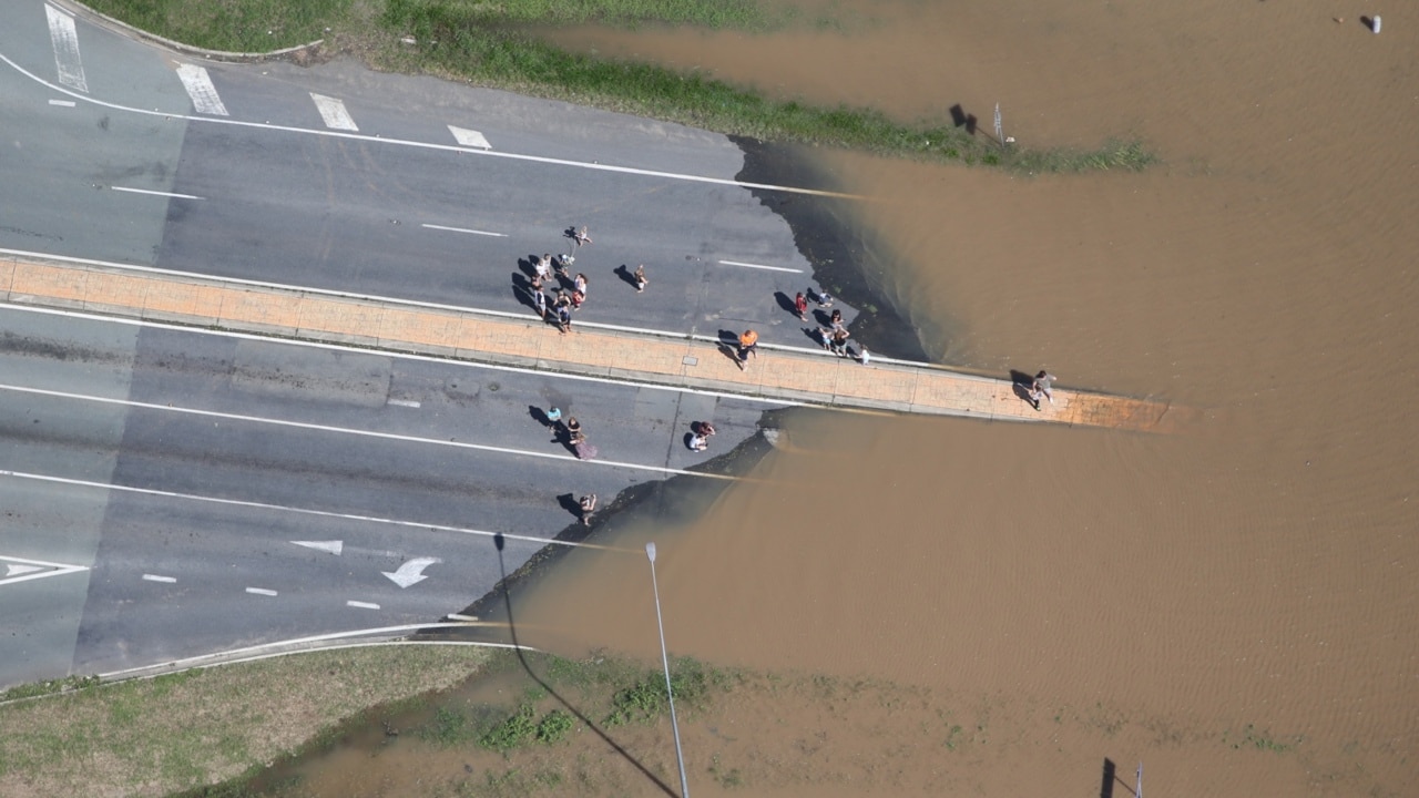
Flash flooding has been reported by the Department of Transport and Main Roads in Helensvale on the Gold Coast.
Helensvale Road, between Woodside Place and Hannaford Place is flooded southbound towards the Pacific Motorway as of 8:54pm
Siganto Drive between Grey Gum Court and Helensvale Road is flooded in all directions and all lanes as of 8:51pm.
BOM Meteorologist Harry Clark says today had been suppressed with dry air above the southeast, but that was changing fast.
“There is a fairly chunky line of showers coming ashore and there is the odd lightning strike in there as well and that is really a taste of what will be more widespread tomorrow,” Mr Clark said.
“We could probably see another 10-20mm which is not out of the question … as you can see on the radar it’s changing quite quickly.”
It comes after a severe weather warning for damaging winds, heavy rainfall, abnormally high tides and dangerous surf conditions was updated for southeast Queensland this morning.
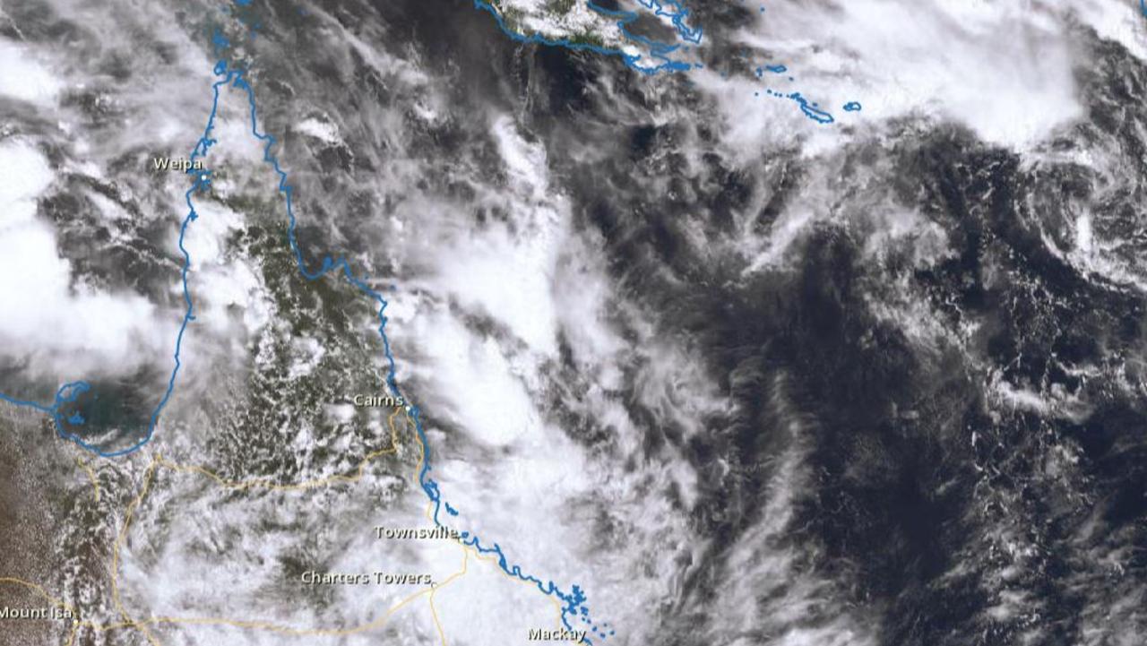
Currently an upper low over northern NSW is forecast to move into the southeast during the day and become slow-moving.
Don't be fooled by the dry conditions in #SEQ currently. A large line of heavy showers is moving in the from the east. With a more significant area of rain offshore, expected to move ashore overnight. #Brisbane Radar: https://t.co/riY9pcwTet pic.twitter.com/LCJLBSLKy2
— Bureau of Meteorology, Queensland (@BOM_Qld) December 12, 2020
“A developing surface trough off the southeast Queensland coast will deepen in response to the upper-system, with a low-pressure system likely to develop and shift southwest towards the coast late on Sunday,” BOM have reported.
“Abnormally high tides exceeding the highest tide of the year are expected to develop about the southeast Queensland coast on Sunday morning’s high tide.
“Dangerous surf conditions are also expected to develop during Sunday and in combination with the abnormally high tides could lead to significant coastal erosion about areas exposed to wave actions.”
The wet weather is likely to continue for the majority of December.
“We’ve been pretty dry until recently … the main story really is that the pattern has changed, we will probably see more bursts of rain, maybe not to this scale, it’s hard to say though,” Mr Narramore said.
There are some who are excited for the wild weather, with 15-year-old surfer Liliana Karos from the Gold Coast and her friend keen to make the most of the big swell.
“It’s been like small over the last couple of weeks and days and it hasn’t been very good so it’s nice to have a couple of good waves come in,” Ms Karos said.
“It’s a bit scary but you know, it’ll still be fun.”
Southeast Queensland could be smashed by more than a month’s worth of rain in just days as La Nina sees the state prepare for flash flooding, severe storms and king tides.
A flood watch has been issued for parts of the state stretching from Fraser Island to the Tweed with water catchments, including the Brisbane River, likely to be affected on Sunday and Monday.
Localised flooding is also likely to impact roads with authorities bracing for falls of over 200mm as the slow-moving trough coming in from the ocean dumps down.
A whopping 92.4mm of rain has been recorded at Sunshine Coast Airport since 9am on Friday, while Nambour reported falls of 27.2mm in the same time frame.
Brisbane has received 11.8mm since 9am Friday, while it was a little wetter at the Airport where 16.2mm was recorded.
On the Gold Coast, Coolangatta has reported 25.6mm since 9am.
SCROLL DOWN TO SEE THE LATEST SOUTHEAST QUEENSLAND RAINFALL FIGURES
Bureau of Meteorology’s Dean Narramore said December monthly averages for December ranged from about 100mm towards the ranges and closer to 150-170mm along the coast.
While December is usually the start of the wet season in Queensland, he said it was likely being intensified due to La Nina.
“If you look at the forecast of the rainfall in the coming days at a number of locations will probably approach or if not exceed the monthly averages over the next four days,” Mr Narramore said.
“La Nina provides more moisture in the atmosphere generally, so it means any weather system that comes through has more moisture to work with which means more widespread and heavy rain.”

Sunday and Monday are expected to be the biggest days for the rainfall, but will pair up with huge waves reaching potentially 8-10 metres high and king tides.
“The highest tides of the year combined with the heavy rainfall and some pretty big season swell with the low off shore could see some low lying inundation and saltwater flooding,” Mr Narramore said.
LATEST SOUTHEAST QUEENSLAND RAINFALL FIGURES
AMBERLEY 12.8MM
ARCHERFIELD 17.2MM
BEERBURRUM 16.2MM
BEAUDESERT 11.8MM
BRISBANE 11.8MM
BRISBANE AIRPORT 16.2MM
CANUNGRA 11.8MM
CAPE MORETON 16MM
COOLANGATTA 25.6MM
GATTON 11.6MM
GOLD COAST SEAWAY 20MM
GREENBANK 15.8MM
NAMBOUR 27.2MM
REDCLIFFE 19.6MM
ALEXANDRA HILLS 16MM
SUNSHINE COAST AIRPORT 92.4MM
TEWANTIN 19.2MM
OAKEY 18.4MM
TOOWOOMBA 11.6MM
WARWICK 12.8MM

Piles of heartbreak: Ingham counts devastating cost of floods
The Hinchinbrook region has begun counting the cost caused by the “perfect storm” as talk turns to potential buybacks and re-building homes ravaged by the floods.
Search for man missing in flood waters as NQ faces another 300mm monster
A search and rescue mission is underway in NQ for a man who drove into flood waters while the region braces for an active monsoon trough expected to dump falls of up to 300mm.