
Strong winds, flooding tipped in severe weekend weather
The southeast is bracing for a weekend of heavy rain, gale-force winds up to 90km/h and abnormally high tides.

QLD News
Don't miss out on the headlines from QLD News. Followed categories will be added to My News.
A severe weather warning for ‘damaging winds, abnormally high tides and dangerous surf’ has been issued for this weekend from Fraser Island all the way down to to Coolangatta.
The highest tide of the year is expected on Sunday morning which will coincide with the worst of the weather.
Dangerous surf, damaging wind gusts and coastal erosion are all likely.
Locations which may be affected include Gold Coast, Sunshine Coast, Coolangatta, Moreton Island, Fraser Island, Hervey Bay, Cleveland and Redcliffe.
A flood watch warning for the southeast has also been issued by the Bureau of Meteorology with a number of catchments likely to be affected.
The warning is from Fraser Island to the Queensland Border with ‘river level rises above the minor flood level’ likely.
The Bureau warned localised flooding and disruption to transport routes are possible in the area from Sunday to Monday.
The most likely catchments to be affected are Upper Brisbane River, Lower Brisbane River, specifically the Bremer River, Warrill Creek and Brisbane Creeks, the Noosa River, Sunshine Coast Rivers and Creeks, Pine and Caboolture Rivers, Logan and Albert Rivers, Gold Coast Rivers and Creeks.
And as most of the South East prepares to receive the first of its predicted rainfalls this evening, 11.5mm was reported at Goondiwindi this afternoon, following another report of 50mm out at Isisford. Jundah in central Queensland also topped 38mm as well.
More modest falls have also already occurred around Toowoomba, with 20mm being recorded at Rockside Mt Alert and 16mm at Oakey since 9am this morning.
At 3.21, the Bureau of Meteorology issued the first of the weekend’s severe thunderstorm warnings for damaging winds, large hailstones and heavy rainfall for people in parts of Maranoa and Warrego and Darling Downs and Granite Belt Forecast Districts.
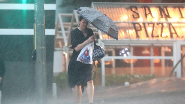
And as the downfalls begin, RACQ has warned Queensland drivers about the risks of flash flooding ahead of the expected weekend deluges.
“Flood waters are incredibly dangerous and it’s not worth taking that risk and driving through,” RACQ spokeswoman Clare Hunter said.
Ms Hunter said the coming conditions could converge with Christmas traffic to create dangerous driving conditions.
“Switch your headlights on, slow down and leave more space between your vehicle and the vehicle in front to avoid a collision, as the roads become more slippery when wet,” she said.
“It’s also a busy time of year with people getting around and catching up with one another during the festive season and doing the Christmas shopping, so please pack your patience in the rain.”
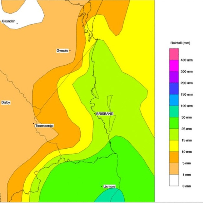
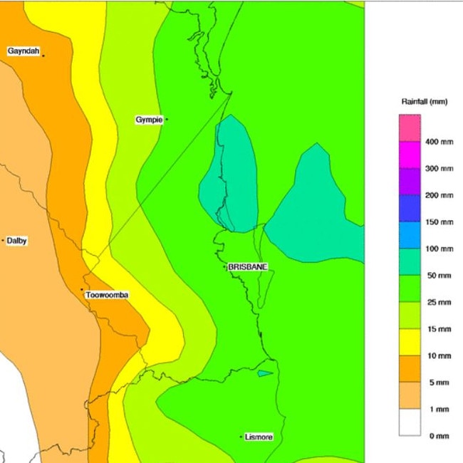
Up to 200mm of heavy rain, flooding and gale-force winds are forecast to lash southeast Queensland from today, with early rainfall already making its way north from the NSW border.
The Bureau of Meteorology has warned Queensland’s wet weekend could turn severe, with a possible low pressure system forming off the coast dumping up to 200mm in two days.
The worst weather is likely on Sunday.
Meteorologist Livio Regano said the event could lead to winds of more than 60km/h, sustained rainfall and the possibility of isolated flooding from the border to the Fraser Coast.
Heavy rain and gale-force winds developing along the southeast coast this weekend, with rainfalls potentially exceeding 100mm on Sunday, accompanied by dangerous surf on the year's highest tides. For the latest warnings visit https://t.co/FBmpsInT9o #seqweather pic.twitter.com/1g8pO6ahrA
— Bureau of Meteorology, Queensland (@BOM_Qld) December 10, 2020
“Depending on how far north the system travels, we could see Fraser get smashed with winds and rain, which would be great to see,” Mr Regano said.
‘With systems like this, those south of it normally cop the most rainfall.
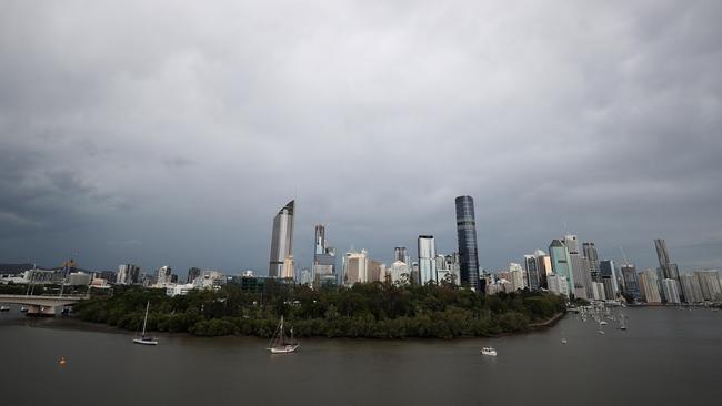
The prediction comes as rain has already “bucketed” down across parts of inland southeast Queensland and the Gold Coast, with the system hitting Brisbane from noon.
“While we did predict showers in the evening, things are still going to plan rainfall wise down on the coast,” he added.
The chance of some #severe weather developing through parts of SE #Qld late this weekend. Currently watching a possible low pressure system. If it forms, it may bring heavy #rain & even some areas of #flooding from Sunday or Monday. Keep watch https://t.co/5cAtwqREhQ@QldFES pic.twitter.com/gd557aSDR3
— Bureau of Meteorology, Queensland (@BOM_Qld) December 10, 2020
“We’ll see those initial systems continue to spread north and will see more consistent rainfall conditions on Saturday.”
The southeast could also be in for a wet Christmas, with initial forecasts from Weatherzone predicting a mostly cloudy day with showers, with a minimum of 22C and a maximum of 30C.
Meanwhile, North Queensland is set to experience a Madden-Julian Oscillation, which will bring consistent rainfall over a 40-day period.
“A lot of townships will be seeing more continued rainfall over the next month, which is something normally attributed to the Queensland tropics.”
“While it won’t be as severe as the southeast’s rain, I bet it’ll still be welcomed by everyone up there.”
The Bureau has already this week warned of the possibility of “significant storm tide” events on the Gold and Sunshine Coasts, along with waves of up to eight metres possible.
☔ï¸Get those brollies out! ☔ï¸
— Qld Fire & Emergency (@QldFES) December 11, 2020
We’re expecting severe weather to hit parts of SEQ this weekend.@BOM_Qld says a possible low-pressure system may bring heavy rain & flooding from Sunday. Now’s the time to create a plan B on how to get home, in case you’re faced with flooded roads! pic.twitter.com/IT5GftwkKu
Join the conversation

‘From C’s to straight A’s’: Meet Queensland’s smartest student
A 17-year-old Queensland graduate will be named the state’s top student at the Queensland Certificate of Education Achievement Awards on Saturday night, after receiving an ATAR of 99.95.
Read more

‘It’s time’: Why Hannah Clarke’s parents are leaving Brisbane
Five years after a tragedy that horrified the nation and shattered a close-knit Queensland family, Lloyd and Sue Clarke are ready to begin their next chapter.
Read more