
’Shock to the system’: Icy winds, frost as temps plummet to 0C
The weather bureau has warned those in southern Queensland to brace for a cold snap from the weekend, with the temperature to drop to 0C in some parts. FULL FORECAST

QLD weather news
Don't miss out on the headlines from QLD weather news. Followed categories will be added to My News.
The weather bureau has warned those in southern Queensland to prepare for a ‘shock to the system’ as a cold snap hits the region from the weekend, causing temperature to drop to 0C in some parts.
The drop in the mercury, which will continue into early next week, is caused by a southerly cold front, which will also potentially bring in strong winds and a high chance of frost.
“A cold front should hit over the weekend, with cold air over the southern parts especially this coming Tuesday that will cause a drop in both the minimum and maximum temperatures,” metrologist Morgan Pumpa said.
“There is a high chance of morning frost for much of the region and the winds are expected to turn south-westerly, potentially reaching 25 to 35km/h. It will be a bit of a shock to the system.”
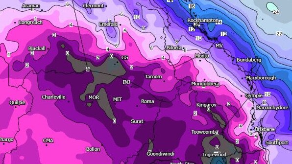
Toowoomba is expected to cop the brunt of the cold snap with the thermometer expected to reach a maximum of just 14C on Monday.
Meanwhile, Oakey will hit a low of 0C on Tuesday with a top of 18C before warming up to 21C on Wednesday.
Brisbane will drop to 8C on Tuesday, with similar temperatures expected on the Sunshine and Gold Coasts.
BOM confirmed that the cold snap will bring temperatures below average for this time of year.
“It is the last month of autumn and we are getting closer to winter so the cold snap is expected but the temperatures it is bringing are lower than average,” Ms Pumpa said.

Storm shield: How AI will protect our state of disaster
Queensland has secured world-first AI storm detection technology in a $3m partnership between Suncorp and the state government to revolutionise natural disaster response.

Hail, rain, wind, SNOW: Winter storm on Qld collision course
A rare winter storm threatens to dump 15cm of snow on Queensland's Granite Belt this weekend as forecasters warn of an incoming polar air mass.