
‘Severe’ Tropical Cyclone Alfred inching closer to Qld coast
New modelling has sparked fears TC Alfred could turn back towards the Qld coast in coming days while abnormally high tides and gale-force winds are expected this weekend.
QLD weather news
Don't miss out on the headlines from QLD weather news. Followed categories will be added to My News.
Tropical Cyclone Alfred is forecast to inch closer to the Queensland coast from Sunday bringing severe hazards including abnormally high tides and gale-force winds.
It comes as the latest modelling forecasts predict TC Alfred could cross the Queensland coast by the end of the week.
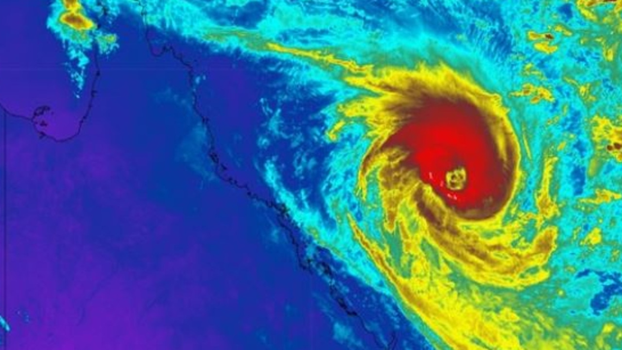
After being upgraded to a category four system, TC Alfred again weakened to a category three and then was again downgraded to a category two system, the Bureau of Meteorology said just before 11pm Saturday.
Alfred was about 475 km east northeast of Rockhampton and 400 km northeast of Bundaberg.
“Tropical Cyclone Alfred is tracking south-southwest over the Coral Sea and may move closer to the Queensland coast before shifting southeast and away from the coast later on Sunday and Monday,’’ the advice said.
“Alfred is expected to slow down and is likely to turn westward, moving toward the southern Queensland coast from mid-next week.”
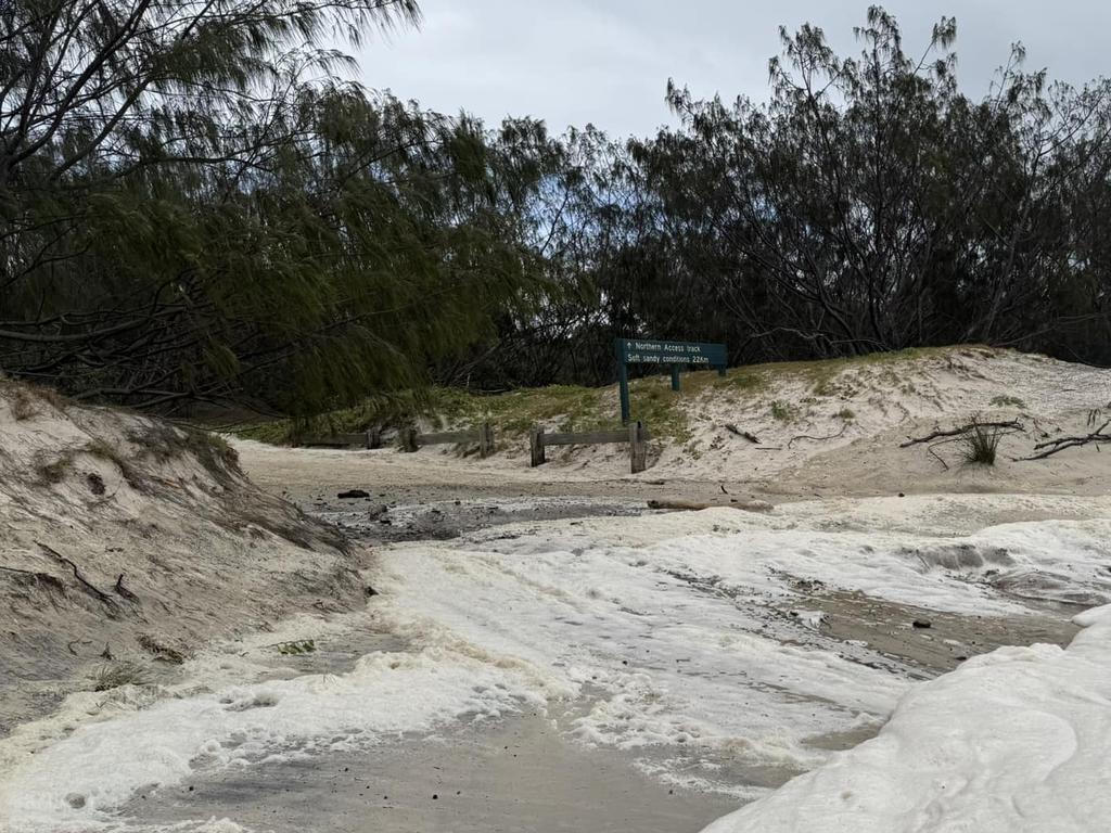
Strong to gale-force winds may develop this weekend across the southern Great Barrier Reef Islands including Heron and Lady Elliot Islands and to K’gari.
A large and powerful to potentially damaging easterly swell as well as abnormally high tides are forecast to develop about exposed central and southern Queensland beaches, possibly extending to northern New South Wales from Monday.
Gympie Regional Council warned residents between Inskip Point and Cooloola Coast to “prepare now” for Tropical Cyclone Alfred Saturday afternoon.
In a post shared on Facebook, Gympie Regional Council issued a warning for areas also including Tin Can Bay and Rainbow Beach.
Gympie Regional Council said while TC Alfred was expected to stay offshore, it could bring abnormally high tides, severe beach erosion along the southern Queensland coast and hazardous surf conditions.
Residents in the warning areas were told to expect strong wind gusts, dangerous beach conditions with extreme waves and coastal erosion risk due to abnormally high tides.
The warning advised residents to prepare by parking cars away from trees undercover, secure loose outdoor items and trim overhanging tree branches.
It also said to make an emergency kit, and avoid coastlines and rough surf.
Visitors, campers and caravanners have been urged to leave the area while it is safe and to pack up tents, move boats, jet skis and kayaks onto land.
The Bureau of Meteorology issued a warning as of 4pm TC Alfred was 445km northeast of Bundaberg.
“Alfred may then be slow moving with the chance to turn westwards and move towards the southern Queensland coast from mid-next week,” the warning said.
“It may move closer to the Queensland coast today before moving southeast and further away from the coast during Sunday and Monday.”
The warning said to expect “strong to gale-force winds” which may develop this weekend across the southern Great Barrier Reef Islands including Heron and Lady Elliot Islands and to K’gari.
“Severe coastal hazards are likely for southern Queensland and northeast New South Wales,” it said.
“A large and powerful to potentially damaging easterly swell as well as abnormally high tides are forecast to develop about exposed central and southern Queensland beaches from later today, possibly extending to northern New South Wales from Monday.”
Bureau of Meteorology forecaster Jonathan How confirmed TC Alfred would move closer towards the Queensland coast today.
“On Saturday, severe Tropical Cyclone Alfred will remain as a severe category three system and continue moving in a southwest direction, slightly closer towards the central Queensland coast,” he said.
“On Sunday, it is forecast to turn again towards the southeast and move away from the coast as a category two system, and by Sunday night, it is expected to be well east of Rockhampton.
“We did see a wind gust of 150km/h, but closer to the centre of the cyclone, we are seeing sustained winds near the centre of 155km/h, and wind gusts to 220km/h over the open water.”
Bureau of Meteorology senior meteorologist Sarah Scully said a coastal crossing could not be ruled out.
“There are early indications that it may change direction and start drifting back towards the Queensland coast,” Ms Scully said.
“At the moment, we can’t rule out a coastal crossing.
“Tropical Cyclone Alfred will drift towards the Queensland coast today, before weakening to a category two system and changing direction tomorrow, where it will start to move south eastwards away from the coast and then it’s expected to maintain that tropical cyclone intensity and continue its south east trajectory until Wednesday.
“From Wednesday onwards, there are early indications that TC Alfred may change direction again and start to drift back towards the Queensland coast, which will, of course, start to see an increase in both areas of rain, gusty showers, and storms.”
Ms Scully said that southern Queensland and northern New South Wales could be impacted by Tropical Cyclone Alfred.
“If it starts to drift back towards the coast again, the southern half of the Queensland coast, but also northern parts of the New South Wales coast could be impacted by that,” she said.
While TC Alfred is expected to be well off the Queensland coast on Sunday, Mr How said Alfred could turn back towards the state later in the week.
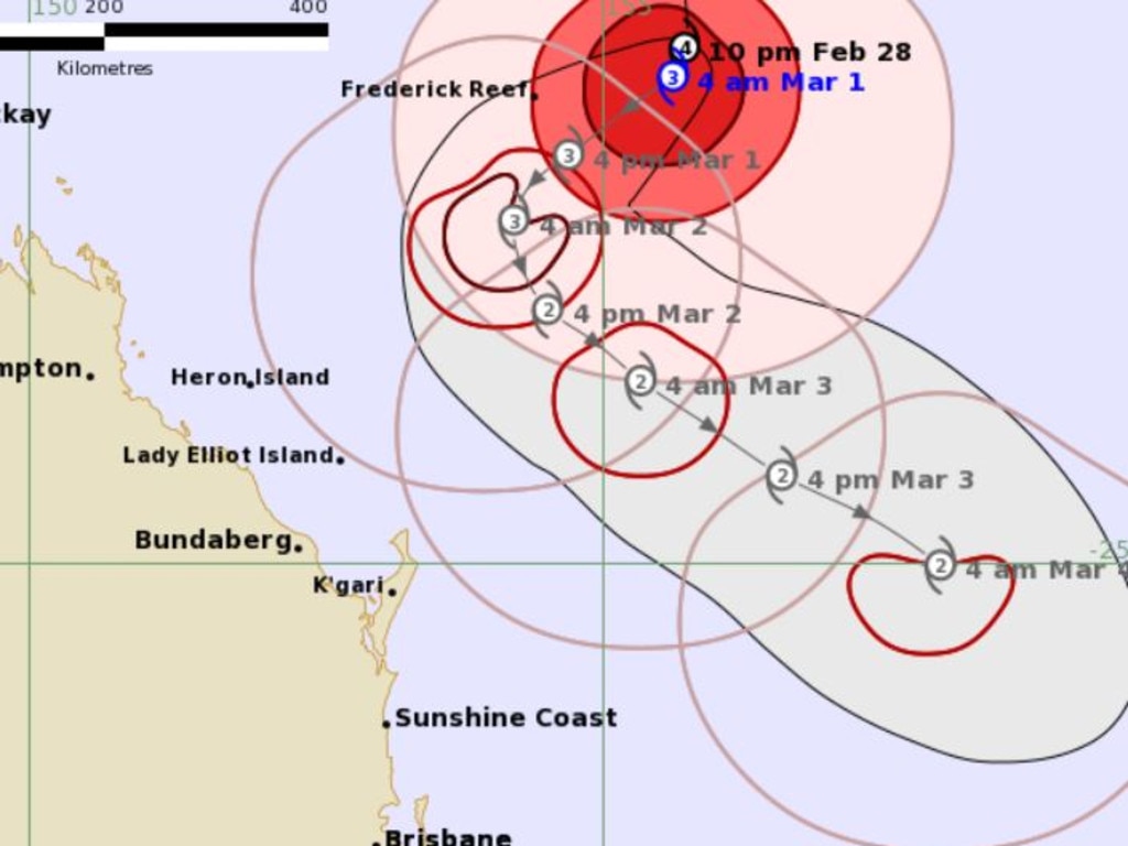
“As we head into Monday, severe TC Alfred is expected to continue moving in that south easterly direction, and early next week, it is expected to lie well east of K’gari and the Sunshine Coast,” he said.
“For the middle of next week, it is expected to become slow moving, and could even curve back towards the Queensland coast and from there, there is still a range of possibilities with regards to its exact movement and just how close it will come to the coast, and this will depend on a number of factors, including how the tropical cyclone interacts with other systems in our region.”
According to Thomas Hinterdorfer of Higgins Storm Chasing, new modelling data suggests TC Alfred could veer towards SEQ later in the week.
“Tropical Cyclone Alfred is currently a fairway off the Capricornia Coast, but with the way these steering patterns are working, the system is expected to move closer in a southwest direction towards the Queensland coast today,” Mr Hinterdorfer said.

“The system will then interact with an upper level trough moving across southeastern Australia tomorrow and into Monday, which will force the system to move a bit more south and then take a south east track.
“There is the anticipation that as the upper level trough moves further east, it’ll actually force the system to move back west towards South East Queensland.”
According to Mr Hinterdorfer, the four major models are suggesting a westward track towards Queensland.
“The four major models that we look at among other models, are all indicating that this westwood track is the most likely scenario at this stage,” he said.
“Nothing before Tuesday says a landfall is expected, but then from Wednesday onwards, it gets a little bit more interesting with the model scenarios as they’re currently playing out.”
Mr Hinterdorfer went onto add that there is a possibility that TC Alfred could make landfall.
“There’s definitely the possibility of it from probably Wednesday onwards or midweek onwards, several models have that scenario at the moment, but of course, we need to let them play out a little bit more just before we hard lock it,” he said.
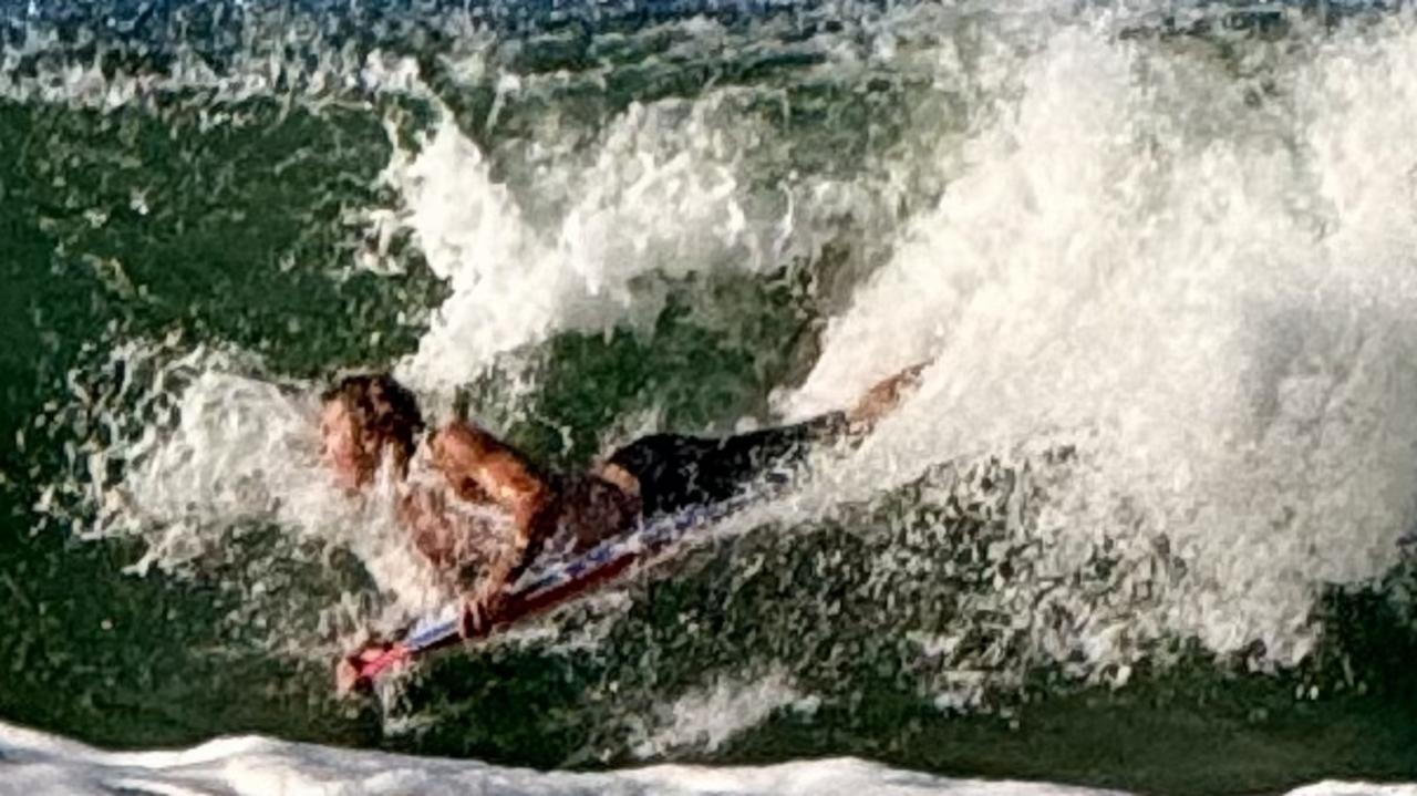
In addition to generating strong wind gusts, Alfred is also producing hazardous conditions along the Queensland coastline.
“Although severe Tropical Cyclone Alfred remains well offshore, it is generating hazardous coastal conditions for areas south of Mackay and down towards the New South Wales border,” Mr How said.
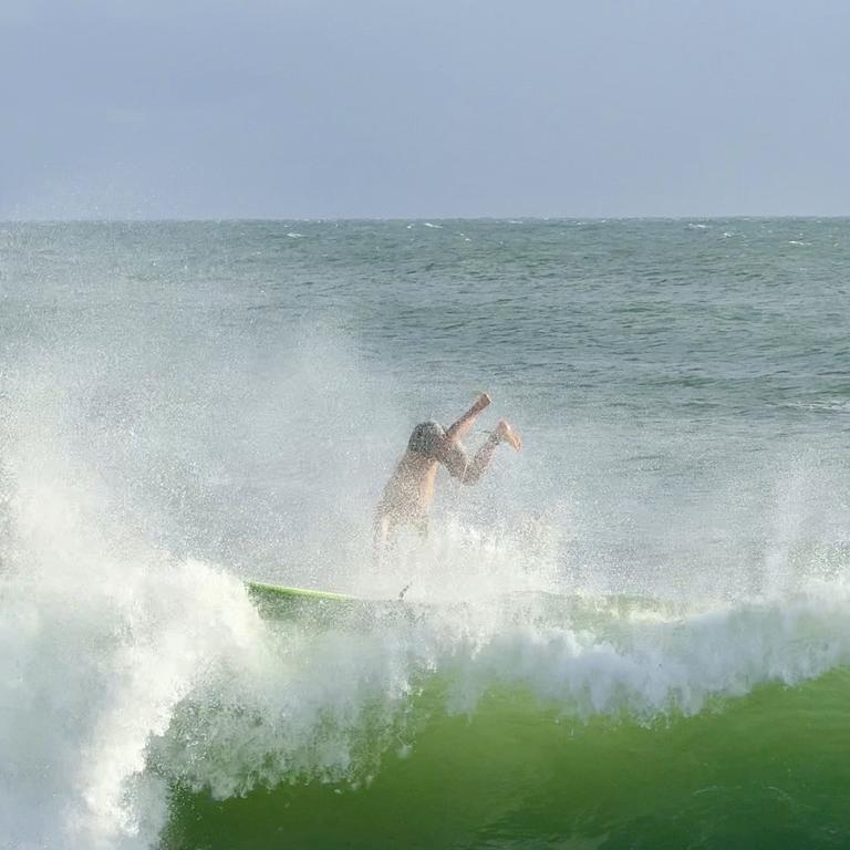
“People should be aware that if they’re heading to the water or the beach, current conditions can be dangerous for swimming, rock fishing and boating.
“We will see in these areas powerful waves in addition to regular high tides, and these were combined to produce abnormally high tides that could cause coastal flooding along the foreshore and with these very powerful waves, severe beach erosion is also possible north of the Sunshine Coast initially, but these could extend further south depending on Tropical Cyclone Alfred’s movement.”
Marine wind warnings are current for all waters south of Mackay to the Sunshine Coast, with a storm force wind warning in place for the Great Barrier Reef.
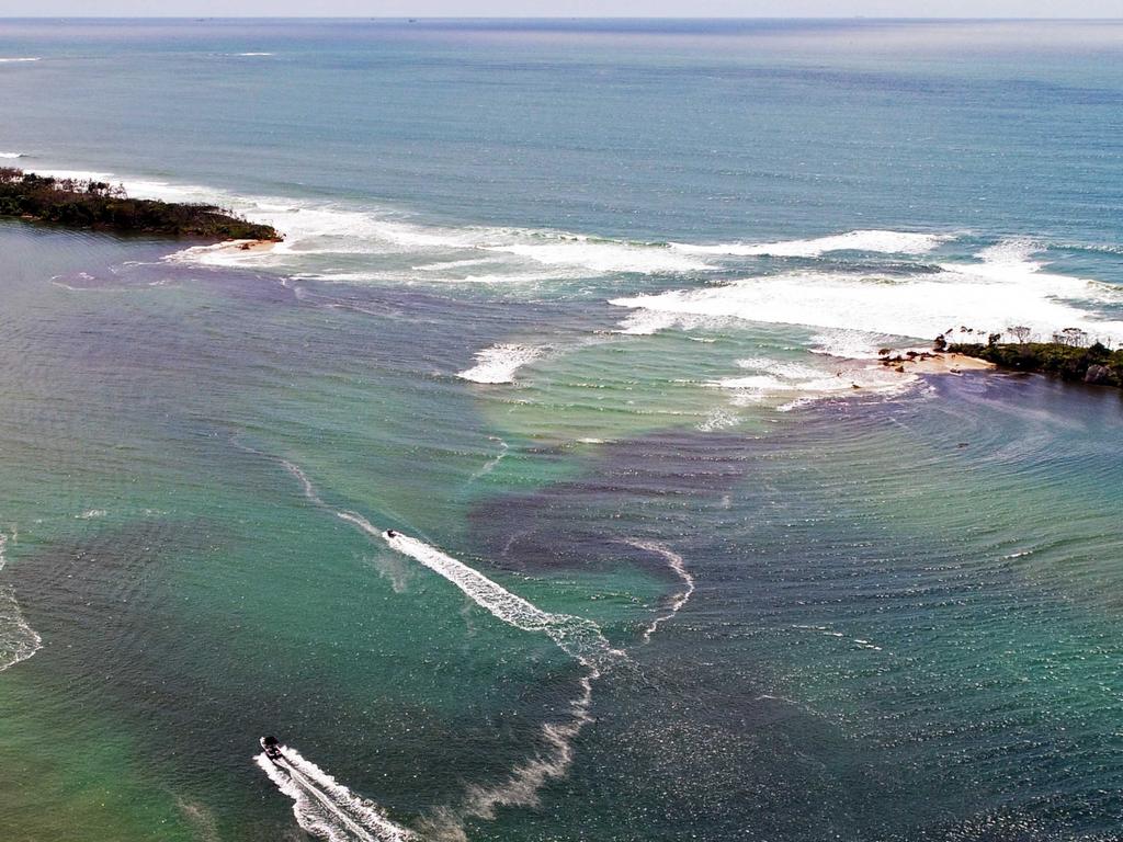
It comes as the iconic Bribie Island is at risk of ripping in half and leaving parts of the Sunshine Coast facing a “real life nightmare”.
A Sunshine Coast community group has raised concerns that Tropical Cyclone Alfred could have a devastating impact on the northern tip of Bribie after water was seen gushing over the island.
Ocean Beach at Bribie Island is awash with sea water, with access to the popular four wheel drive hot spot and camp sites cut off by waves whipped up by the cyclone.
The wild weather comes amid fears the northern tip of Bribie Island could experience a second significant breakthrough as a result of the impact of Tropical Cyclone Alfred.
Campers have been strongly advised to leave K’gari, Inskip and Cooloola camping areas as Alfred moves south.
Queensland Parks and Wildlife Service is not accepting camping bookings in the protected areas, with refunds available for those who have already booked.
Despite the cyclone’s distance from the coast BOM forecaster Jonanthan How yesterday said it is generating hazardous conditions for parts of Queensland’s coast.
“First, for gale force winds across the Great Barrier Reef and strong winds warnings between Townsville and down towards K’gari,” Mr How said.
“We also have a hazardous surf warning for the Capricornia and K’gari coast, so roughly between Yeppoon to Hervey Bay.”
Mr How said these areas can expect very windy conditions along the foreshore and out onto the water, and large swells with waves of two-to-three metres.
More Coverage


Join the conversation

Monster weather system brings storm, heavy rain to Qld
Brisbane and surrounding parts of the southeast have been hit by storms and heavy rainfall this afternoon as a 3000km-long monster low moves across the state.
Read more

Wild storms, polar blast as 3000km monster low barrels towards Qld
The system, which stretches 3000km from north to south and encompasses 30 per cent of Australia, is forecast to pack a punch when it hits Queensland.
Read more