
Rain expected to ease later in the week after wet Easter weekend
A severe thunderstorm warning has been cancelled for parts of the Wide Bay and Burnett district but moderate rainfall still hovers over the southeast.
QLD weather news
Don't miss out on the headlines from QLD weather news. Followed categories will be added to My News.
A severe thunderstorm warning has been cancelled for parts of the Wide Bay and Burnett district.
Severe thunderstorms and heavy rain that could lead to flash flooding was earlier forecast to impact Gayndah, Mundubbera, Biggenden and Eidsvold over the next several hours from 5pm but the Bureau of Meteorology cancelled the warning at 5.45pm.
Moderate downpours could still be seen on the radar at 6pm, particularly in the Kingaroy region, while a larger band of rain was further south stretching from Ipswich down into NSW. A smaller rain band was hovering over Pittsworth down to Stanthorpe, with scattered patches of rain elsewhere.
Downpours had been seen earlier at Derra Alert, south of Mundubbera, which recorded 55mm in an hour.
It came as weather authorities admitted to being caught off-guard by a sudden change in conditions that caused a severe weather system, that was expected to shift out to sea, to change direction and make landfall.
The Bureau of Meteorology was late last week warning of intense rainfall and life-threatening flash flooding across the Easter long weekend.
That was downgraded on Monday due to expectations the weather system was shifting west and not likely to hit the Queensland coast.
However, conditions changed suddenly overnight, with falls in excess of 160mm causing flash flooding.
More than 160mm has fallen near Peachester in the Sunshine Coast hinterland since Monday night, with 148mm at Mt Glorious in the Moreton Bay region and 111mm at Landsborough.
Across the Greater Brisbane region, 84mm was recorded at Beachmere, 75mm at Murrumba Downs and 76mm at Redcliffe.
Pieter Claassen from the Bureau of Meteorology said that it was the increase in onshore flow and south-easterly winds because of the low increase that caused rainfall to unexpectedly intensify overnight.
He said that while they didn’t see that low directly interact with the southeast Queensland coastline like they thought would happen yesterday, the low increase was enough.
“Because of that low increase, we had the massive south-easterly winds on the southern side.
“So, we had stronger onshore flow, which helped to bring that more widespread rain.”
Mr Claassen said that this often happens in overnight periods, where we see a strengthening of winds offshore which helps to bring in unexpected rain.
“That low did remain offshore and it didn’t interact directly with the coastline, it was more just that on shore flow that brought that widespread rain in those regions last night.”
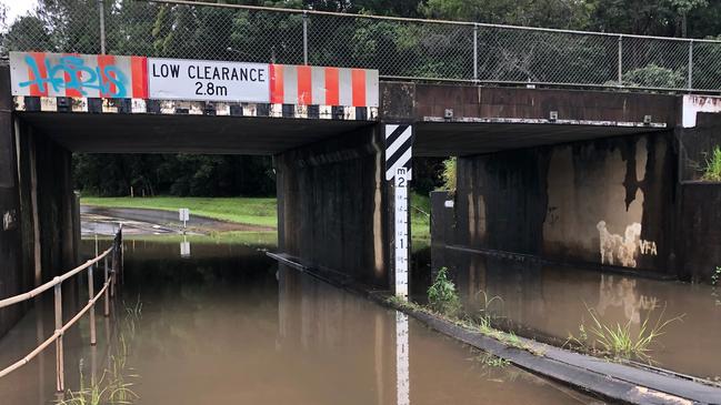
At 10.15am, Queensland Police Service alerted they were closing Gap Creek Rd at Indooroopilly. Police say a number of motorists were ignoring the closure and attempting to cross floodwaters.
BRISBANE: Police are currently closing off Gap Creek Rd on the Indooroopilly side due to flooding, a lot of motorists still attempting to get through. Please avoid if you can. pic.twitter.com/GpsLpnpiVJ
— Queensland Police (@QldPolice) April 6, 2021
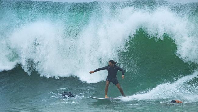
Meanwhile, all Gold Coast beaches and most Sunshine Coast beaches have been closed due to dangerous surf conditions.
A severe storm warning has been issued for parts of the Darling Downs and Granite Belt, with slow-moving rain areas with embedded thunderstorms across the forecast district.
More than 60mm has fallen at Ballandean Hill in two hours.
A severe thunderstorm warning for heavy rainfall has been issued for parts of the Darling Downs and Granite Belt. Details here: https://t.co/TlyZw7Qu5Upic.twitter.com/fdX5ZEKcVx
— Bureau of Meteorology, Queensland (@BOM_Qld) April 5, 2021
“Severe thunderstorms are likely to produce heavy rainfall that may lead to flash flooding in the warning area over the next several hours. Locations which may be affected include Stanthorpe,” the warning states.
The Bureau of Meteorology’s Matt Marshall said that although there were no warnings issued overnight for heavy rainfall in southeast Queensland, downpour remained consistent throughout the night and into the early hours of the morning.
Another 85mm expected to hit the Sunshine Coast over the next two days with Brisbane forecast to get 53mm.
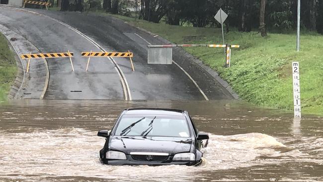
The Bureau of Meteorology has issued a moderate flood warning for the Upper Brisbane River basin after 150mm of rainfall was recorded over the Stanley River catchment area since 9am Monday.
The Stanley River at Woodford is currently 3.53m and rising.
River levels are expected to exceed the minor flood level (5m) during Tuesday morning. A peak around the moderate flood level (6.1m) is likely during Tuesday afternoon.
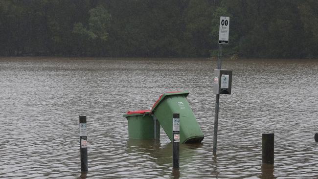
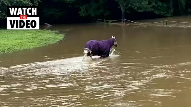
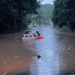
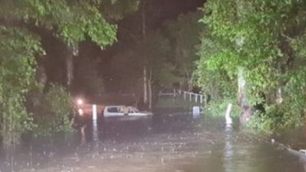
Queensland Police Service is warning of flash flooding across southeast Queensland with numerous roads closed.
Heaviest hit has been the Sunshine Coast, with flash flooding and road closures impacting Beerwah, Peachester, and the Glass House Mountains.
Birds Road at Guanaba, in the Gold Coast Hinterland, and Paradise Rd between Gardens Rd and Radius Dr at Larapinta, in Brisbane south, have also been closed by flash flooding.
The wet weather has also brought down a large tree branch in the centre lanes of Coronation Drive outbound in Toowong.
Roads impacted by flooding in the northern parts of the Greater Brisbane region include
Mott Street, Brendale, Buchanan Road and Leda Boulevard in Morayfield, Hume Road in Caboolture and Old Gympie Road at Six Mile Creek, Elimbah.
In Brisbane’s south, roads impacted by flooding include Chermside Road between John Street and Kinsellas Road West in Mango Hill, Underpass Road near William Berry Drive in Morayfield and Youngs Crossing Road at Petrie.
We are seeing multiple roads impacted by flash flooding around the Sunshine Coast - Beerwah, Peachester Glass House Mountains just a few places. If It’s Flooded, Forget It. #qldtrafficpic.twitter.com/xahRWqbmtX
— Queensland Police (@QldPolice) April 5, 2021
Places hit the hardest across the Easter long weekend included Upper Springbrook with 119mm and Hervey Bay with 83mm. Meanwhile, Northern Sunshine Coast saw 50mm to 70mm, Gold Coast had 20 to 40mm and inner city Brisbane hovered around 20mm.
“There wasn’t necessarily any heavy moments, but it was certainly widespread and persistent this Easter,” BOM Meteorologist Matt Marshall said.
But nothing could deter dedicated surfers as crowds hit the water despite grim conditions.
Local Sunshine Coast surfer Campbell Behan said waves were reaching three to four foot at popular beaches such as Noosa, Snapper Rocks and Kirra Beach.
“After a bit of a dry spell of waves, it was good to get some solid swell finally,” he said.
Rain is expected to ease in the coming days but people are still urged to be careful in the wet weather.
“We could still see some more through the stretch from Hervey Bay to the Gold Coast through into Wednesday,” Mr Marshall said.
“Then there’s finally a bit of sunshine towards the end of the week.”
It comes as a group of 11 campers and a dog were rescued from rising floodwaters in Byfield National Park north of Yeppoon on Sunday night.
A man also died in Gold Coast on Sunday after his car was reportedly bogged causing him to accelerate into a tree.


Former MP withdraws senate ticket to focus on new role
A former Newman government minister has has stepped away from his senator ambitions to instead focus on helping flood-wrecked North Queensland rebuild.
Premier gives take on Miles’ proposed buy-back scheme for flooded residents
The Hinchinbrook region has begun counting the cost caused by the “perfect storm” as talk turns to potential buybacks and re-building homes ravaged by the floods.