
Queensland’s extreme weather future revealed in ARC Centre of Excellence for Climate Extremes report
Mega cyclones, longer heatwaves, harsher fire conditions and drought make up Queensland’s weather forecast future, a confronting new report claims.
QLD weather news
Don't miss out on the headlines from QLD weather news. Followed categories will be added to My News.
Mega cyclones, longer heatwaves, harsher fire conditions and drought make up Queensland’s weather forecast future, a confronting new report claims.
The wild 2023-24 storm season which included the early arrival of cyclones, a delayed monsoon season and unusually warm sea temperatures driving humidity and intense heat bursts, could be Queensland’s new normal.
It comes as Brisbane this week broke an all-time heat record for the longest run of hot overnight temperatures since 1978, recording more than 60 consecutive nights of 20C or higher.
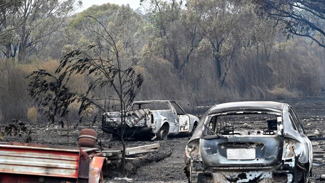
The ARC Centre of Excellence for Climate Extremes (CLEx) released its annual extreme weather report on Thursday, which predicts South East Queensland will face harsh fire conditions and “large declines in rainfall” in coming decades.
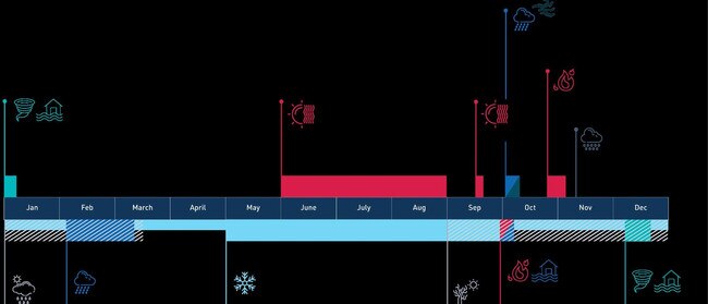
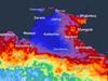
A timeline of extreme weather events across the country shows just two months of regular conditions during 2023 in April and May, with the remainder of the year riddled with heatwaves, cyclones, storms, fire and floods.
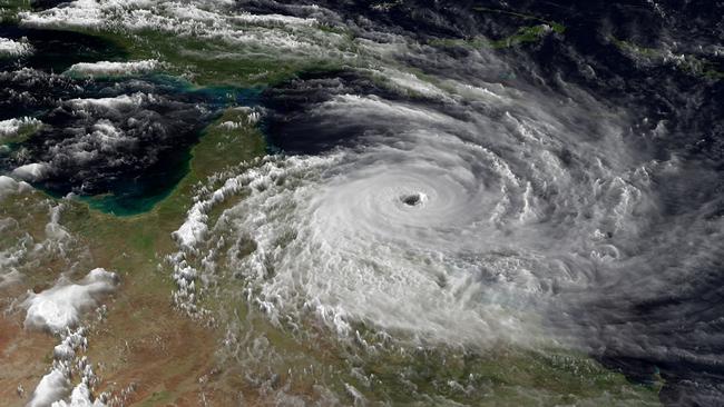
Co-written by more than 30 of Australia’s leading scientists, the report also suggests that climate change is helping cyclones undergo rapid intensification prior to making landfall.
It means while the number of cyclone crossings in Queensland may decrease alongside rising heat levels, the systems that do cross would potentially be more destructive.
ARC researcher and co-author Dr Kim Reid said elongated heatwaves and intense cyclones would be hugely problematic for Queensland’s tourism industry due to high humidity and severe storm risks.
“Heat extremes are increasing and this is a problem for Queensland because of the humidity,” she said.
“Human bodies can’t sweat as efficiently in humidity so that heat is a concern for tropical areas.
“The extremes in the ocean which we call marine heatwaves, will have a huge impact on state tourism. Queensland will bear a lot of the brunt compared to other states.
“And if you’ve got fire seasons overlapping, you don’t have enough resources or firefighters to go around.”
Dr Reid said the dynamics of severe weather events were becoming harder to predict, but scientists were now working on creating higher resolution climate modelling for more accurate forecasting.
“That requires a lot of computer power and funding for supercomputers,” she said.
“The other challenge is we need to observe what’s happening now and Australia’s so big and the bureau manages what they can, but there’s so many remote places, so we do need more funding to our observation network for short-term weather forecasting.
“We have the tech, we have the money, the real issue is political will. But as more people are impacted (by extreme weather) they might start to question more.”
Australia recorded its 8th hottest year on record in 2023 with temperatures 0.98C above average, but it was a record hot year globally.
The year began with above-average rainfall in northern Australia before switching to hot, dry conditions in the southeast in late winter and spring.
Following a record-dry spring, the Bureau of Meteorology declared an El Nino, a climate driver which usually brings below average rainfall and warmer temperatures.
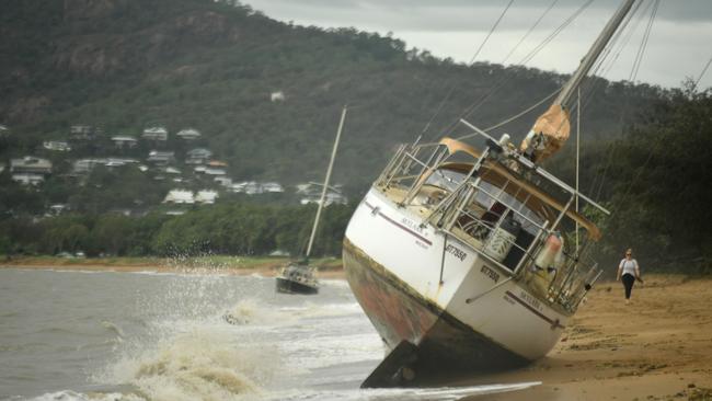
While winter was the warmest on record, above average rainfall was observed in December across much of eastern Australia, particularly in North Queensland following intense flooding caused by Tropical Cyclone Jasper.
Widespread flooding continued for more than two months as a series of troughs swept over the state, compounded by stalling tropical lows, and two cyclones.
An average of four cyclones cross the Australian coast each season between November 1 and April 30, with the Bureau forecasting less tropical cyclones for the 2023–24 season.
El Nino typically reduces the total number of tropical cyclones which form and the number that cross the coast, with La Nina historically known for having more cyclone crossings
The number of tropical lows that form during El Nino years is also typically fewer than the number that form during ENSO-neutral or La Nina year.
Against initial predictions, Tropical Cyclone Jasper appeared in December, an entire month early, developing over the Coral Seal for a week before crossing the North Queensland town of Wujul Wujul.
Queensland was then hit with severe hail storms, a mini tornado and further bouts of flooding in both the north and south over the Christmas holiday period.
Tropical Cyclone Kirrily was officially declared in January, lingering near the coast before crossing at Townsville on January 25.
Kirrily remained active as a tropical low, while a new subtropical low began developing off the east coast.
The subtropical low, dubbed 06U, had the potential to develop into a tropical low due to warm Coral Sea temperatures, but the system never ventured into cyclone territory.
A Bureau spokesman said despite fewer tropical cyclones in recent years, cyclone activity had become more intense.
“Another feature we are already observing and is predicted to be further exacerbated by increased or future climate change is larger rainfall totals occurring with tropical cyclones,” he said.
“This may increase the likelihood of local flooding where tropical cyclones impact coastal locations.”
The Bureau’s latest climate modelling shows El Nino has already peaked and is now declining, with climate drivers to return to neutral in May.
With warming oceans and soaring temperatures, the Bureau has not ruled out another La Nina declaration during 2024.
“The oceans have been the warmest on record globally between April 2023 and January 2024,” the Bureau said.
“These changes may make a difference when predicting future ENSO events based on historical activity.”
More Coverage


Storm shield: How AI will protect our state of disaster
Queensland has secured world-first AI storm detection technology in a $3m partnership between Suncorp and the state government to revolutionise natural disaster response.

Hail, rain, wind, SNOW: Winter storm on Qld collision course
A rare winter storm threatens to dump 15cm of snow on Queensland's Granite Belt this weekend as forecasters warn of an incoming polar air mass.