
Queensland weather: Widespread rain after hottest June day since 2016
After parts of Queensland sweltered through record-breaking 30C-plus temperatures yesterday, widespread drenching rain is now set to impact the southeast.
QLD weather news
Don't miss out on the headlines from QLD weather news. Followed categories will be added to My News.
South East Queensland is set for widespread rain, strong winds and below average temperatures over the next 72 hours after an eight-year weather record was shattered at the weekend.
Sunday was Queensland’s warmest June day since 2016, with temperatures up to 10C above average across the state. Palmerville in the Cape York soared to 33C and Brisbane got to 27C – 5C above average.
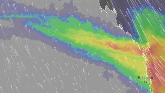
But over the next 72 hours temperatures are set to plummet again with a rainband stretching from the Northern Territory to generate “cooler, breezier and quite gloomy weather”, the Bureau of Meteorology’s Livio Regano said.
“(Tuesday) we have southerly, south easterly winds. Which brings cool air out from the south and quite fresh, quite windy as well. There will be strong wind warnings for small boats.
ðŸŒ§ï¸ A cloudy and wet few days ahead for #SEQld, with rainfall likely peaking tomorrow before easing from Thursday. 10-20mm forecast for tomorrow across southeast, isolated falls over 30mm possible. See the forecast for where you are: https://t.co/jD6i6N90SSpic.twitter.com/trdW1RNedr
— Bureau of Meteorology, Queensland (@BOM_Qld) July 1, 2024
“There is a fairly decent rain band moving across from the west, we get them in winter occasionally, rain in the sense it’s continuous and it’s dark and overcast skies, rather than showers which are lumpy.”
Overnight, the heaviest rainfall totals came on the southern Darling Downs, with Goondiwindi recording 14.2mm, while West Haldon had 14mm. Light rainfall over the southeast meant totals did not exceed 10mm.
“As the next two days unfold, it is likely to intensify and we’re expecting rainfall to increase. Might get up to 15mm in Brisbane today and up to 20mm tomorrow,” Mr Regano said.
Brisbane has a 95 per cent chance of rain Monday, with a chance of a thunderstorms in the afternoon and evening but the “the rainiest day will be tomorrow”.
“In Toowoomba we’re expecting roughly 20mm, Gold Coast 25mm, Sunshine Coast 35mm, so the further north you go, the heavier it gets,” Mr Regano said.
“Bundaberg and Harvey Bay, they’ll get quite a lot of rain, with Bundaberg up to 15mm and Hervey Bay 20mm.”
Queenslanders will receive a brief reprieve on Wednesday before more wet weather forecast for the weekend.
WINTER WEEKEND HEATWAVE
Queenslanders enjoyed an unusually warm winter’s weekend, as temperatures rise as high as 10 degrees above average in some parts of the state.
BOM meteorologist Pieter Claassen said that this abnormally warm weather was thanks to a sharp trough over western Queensland, and northerly winds that have “dragged down some of those warmer temperatures.”
“Yesterday, in western Queensland, we saw the hottest temperatures, up to 10C above average,” he said.
Mr Claassen said that the hottest areas are expectedly “up in the peninsula,” with Palmerville reaching 33C, but that areas like Mt Isa are seeing more notable differences.
While usual June temperatures sit around 25C, Mt Isa was very warm on Sunday, recording a temperature of 32C, seven degrees higher than the average.
Mr Claassen said that these unusually high temperatures are being recorded “right across the north west, in the central area through Longreach where it’s gotten to 30C, and through areas like the Northern Darling Downs, southern Central Highlands and into south eastern Queensland.”
“These are the places where we’ve seen the temperatures most above average today. That’s where we’ve seen 4-10C above average,” he said.

Ice ice baby: Spectacular images of unseasonal frost as Qld freezes
Queensland’s overnight temperatures will increase to double digits in the coming days, following the coldest start to winter in 16 years, bringing frost and ice to many regions. SEE THE PHOTOS

City’s coldest June start in 16 years, feels like MINUS 9.8C out west
Southeast Queensland is shivering through its coldest morning in more than 15 years but feels-like temperatures have dropped to insane levels in the southern inland.