
Queensland weather: Temperatures plummet 12 degrees below average across state
Several parts of Queensland have recorded what is expected to be their coldest day of the year, as some maximum temperatures drop to 12C below average.
QLD weather news
Don't miss out on the headlines from QLD weather news. Followed categories will be added to My News.
Several Queensland centres have experienced their coldest day of the year, with maximum temperatures plummeting 12C below average in many places.
While official 24-hour temperatures are measured from 9am to 9am, weather bureau senior meteorologist Harry Clark said tonight a number of Queensland areas were on track to record their coldest day of the year.
“Today was probably the worst of it,” he said.
“Tomorrow’s going to be quite cool, with a maximum of 16C forecast for parts of Brisbane.
“Tomorrow will be another cold day; it’s not going to get worse but it’s probably not going to get much better till Wednesday.”
The following centres were expected to have recorded their coldest day of the year today
(to be confirmed at 9am tomorrow):
* Sunshine Coast 13.4C
* Brisbane 14.2C
* Gold Coast Seaway 14.2C
* Ipswich 13.1C
* Gladstone Airport 12.4C
* Townsville 14.8C
“There’s a good chance it will stay below those numbers. I’d be highly surprised if we didn’t see a couple of records break.” Mr Clark said.
The weather bureau warned an “unusually intense and cool” upper level trough was moving through Queensland, bringing widespread moderate rain and possible flash flooding.
Weather bureau forecaster Livio Regano said totals up to 100mm couldn’t be ruled out.
“We have the thing called a northwest cloud band linked ultimately to the Indian Ocean,” Mr Regano said.
“When it gets warm and moist, which it is now, you get these bands of cloud originating in the northwest and gradually pouring across Central Queensland.
“Normally they bring rain to southern Queensland and New South Wales … this one’s unusual and it extends a long way further north, reaching right up to Cairns and Cooktown”.
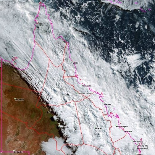
Mr Regano said the upper atmosphere was basically scooping up all the moisture and shooting it to great heights where it’s condensing into a thick layer of clouds.
“There are thunderstorms embedded within the cloud mesh and if you happen to be under one of those you might get these high totals up to 100mm,” he said.
“You might get a little bit of flash flooding in those but for the most part it’s just widespread moderate rain”.
The higher totals are predicted to fall close to Cooktown, while Brisbane is on the skirting of the cloud band and is only predicted to have 20mm.
Mr Regano said it wouldn’t be unreasonable to expect 30mm in the Fraser Island area.
The cold and wet weather is expected to continue until Thursday.
“Wednesday will still be very cloudy, so the temperature may rise a little bit, but by Thursday, it should shoot up considerably,” he said.
CURRENT TEMPS & 7-DAY FORECAST
Read related topics:Weather

Monster weather system brings storm, heavy rain to Qld
Brisbane and surrounding parts of the southeast have been hit by storms and heavy rainfall this afternoon as a 3000km-long monster low moves across the state.
Read more

Wild storms, polar blast as 3000km monster low barrels towards Qld
The system, which stretches 3000km from north to south and encompasses 30 per cent of Australia, is forecast to pack a punch when it hits Queensland.
Read more