
Qld weather: House destroyed as severe storm carries 4000 lightning strikes
A home has been damaged, two women injured and a significant bushfire ignited after a severe storm swept across parts of South East Queensland this afternoon.
QLD weather news
Don't miss out on the headlines from QLD weather news. Followed categories will be added to My News.
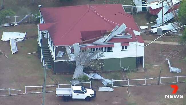
A house has been damaged, two women injured and a serious bushfire that threatened homes has erupted after a severe storm swept through the Somerset region west of Brisbane on Wednesday afternoon.
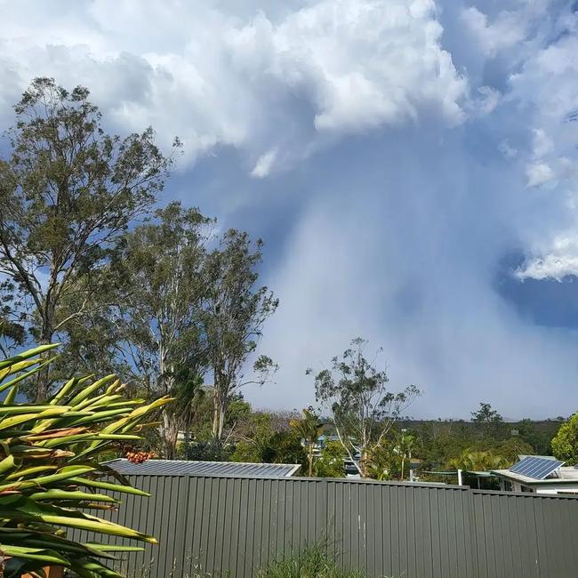
It came after Bureau of Meteorology warnings of the potential for severe storms after a day in which the heat climbed well beyond 40C in parts of the state.
Paramedics were called to a home at Winya, in the Somerset Region, where a house was seriously damaged during the storm that produced more than 4000 lightning strikes, but not much rain.
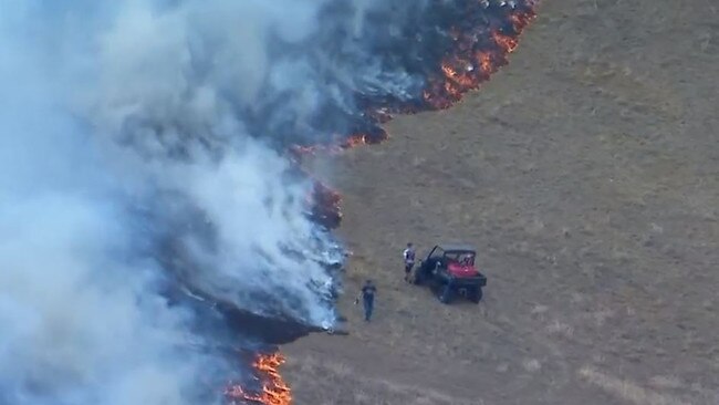
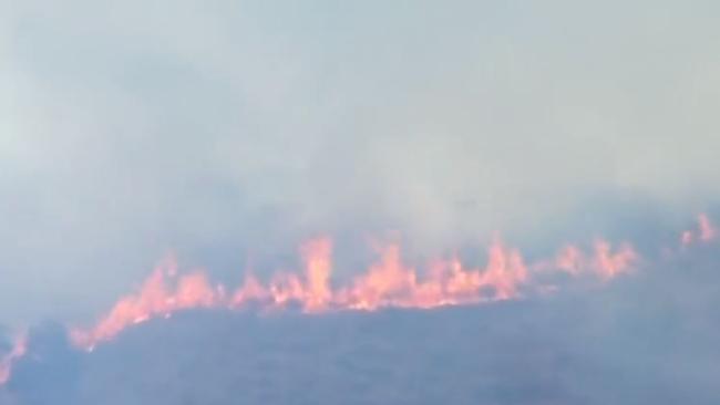
The same storm caused the ignition of a bushfire at Mt Kilcoy, with eight crews fighting to blaze after it erupted at 2.50pm.
Two women were being treated for swelling and facial injuries after the house was extensively damaged by storm activity.
One woman, in her 70s, is being assessed for facial injuries, while a second woman, in her 60s, has swelling.
The Bureau of Meteorology’s Felim Hanniffy said there were more than 4000 lightning strikes in the hour from 2.40pm in Kilcoy and surrounds.
Mr Hanniffy added that the area received 4mm of rain in 15 minutes.
“The storm cell has weakened off again, however there is further risk of isolated severe thunderstorms over the next few hours and evening period in the southeast,” he said.
Of the fires, a QFES spokesperson said homes were at risk earlier between Wunulla Lane, Sandy Creek Road and Costelloes Lane, however extra crews and aircraft were called in where they were able to get the fire under control.
A ‘stay informed’ warning has been issued for the area.
QFES said as of 4:40pm there were no homes under threat and water aircraft remained for structural protection.
Storms then swept north through the Sunshine Coast hinterland and into the Gympie region.
Earlier, the Bureau or Meteorology’s Kimba Wong said hot conditions would contribute to storm activity.
“The trough that is currently travelling through the eastern darling downs and eastern parts of the state is helping to trigger the activity which is expected to hang around the cities for the rest of the week before moving north, forced along by a northerly wind.”
The Sunshine State has sweltered for the first half of the day, with the mercury soaring past 40C by noon.
The hottest part of the state to 2pm was Urandangi, in the northwest, with the mercury climbing to 43.4C at 1.12pm.
The mercury soared past 42C in Winton, Windorah, The Monument and Trepell.
A typically cooler part of the state, the Darling Downs and Granite Belt, is also being struck by brutal “hotspots” and sticky northerly winds with the temperature in Miles reaching 38.9C and 37.5C in Goondiwindi.
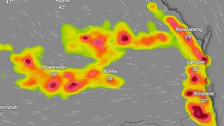
Roma was 40.5C just before 2pm and Gayndah was 39.5C.
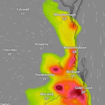
In the southeast, Brisbane reached 31.8C by 12pm, Gold Coast 29.1C, Canungra 33.5C, Sunshine Coast Airport 30.1C and Tewantin 33.6C.
With hot conditions being powered by strong, damaging winds, previous fire grounds reigniting is something the Bureau is on the look out for, according to Ms Wong.
“Dry lightning is not an unlikely possibility, however rain is expected to hit the ground so hopefully that will mean that restarting those fires is not the main concern.
“Lightning can strike outside the main trough though, it is common, so we will be keeping a watch for that.”
PERFECT CONDITIONS FOR WILD STORMS
The perfect mixture for summer storms is being whipped up by “heatwave-like winds” and moist air, with South East Queensland in the firing line from Wednesday.
The Bureau of Meteorology’s Patch Clapp said possible thunderstorms were working their way towards both Brisbane, the Gold Coast and the Sunshine Coast from inland areas.
“There are possible storms forecast for much of South East Queensland in the coming days,” he said.
“These storms will likely bring large hail, damaging winds and a bit later in their cycle, rain.
“The trough is currently moving through the inland areas of Queensland and will head for the coast on Tuesday night and into Wednesday, that's when we can expect to see that predicted storm activity.”
The Bureau has issued a strong wind warning for the Sunshine Coast with 55km/h winds predict.
“The heat and moisture around that hotspot that is sitting more central at the moment is the perfect mixture, we are seeing things come together and that's where this new storm potential is coming together,” Mr Clapp said.
It comes as a brutal heatwave grips central Queensland, with temperatures hitting 43C in some parts.
A heatwave warning has been issued by the Bureau for the Northern Goldfields and Upper Flinders, Central Highlands and Coalfields, Central West, Channel Country, Wide Bay and Burnett and Southeast Coast districts.
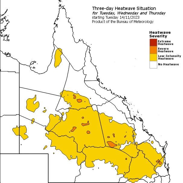
The warning remains in place until Friday, with locations likely to be impacted include Birdsville, Gympie, Taroom and Windorah.
In Brisbane, the Bureau is forecasting a maximum of 31C with a possible chance of light showers on Wednesday, before thunderstorms and torrential Thursday.
On the Gold Coast, a maximum of 30C is expected to hit on Thursday along with strong northerly winds and up to 10mm of rain.
Read related topics:Weather

Ice ice baby: Spectacular images of unseasonal frost as Qld freezes
Queensland’s overnight temperatures will increase to double digits in the coming days, following the coldest start to winter in 16 years, bringing frost and ice to many regions. SEE THE PHOTOS
Read more

City’s coldest June start in 16 years, feels like MINUS 9.8C out west
Southeast Queensland is shivering through its coldest morning in more than 15 years but feels-like temperatures have dropped to insane levels in the southern inland.
Read more