
Queensland weather: 2000km rain band brings renewed warnings of flooding
Queensland is in the firing line of a 2000km freak weather system, triggering unseasonal storms, drenching rain and renewed warnings of flooding.
QLD weather news
Don't miss out on the headlines from QLD weather news. Followed categories will be added to My News.
A 2000km rain band is sweeping across the country and into Queensland, bringing with it thunderstorms, hail and flooding.
A large cold front that began across South Australia’s Eyre Peninsula is marching east, bringing gusty winds, widespread rain and storms to inland Queensland, as well as parts of New South Wales and Victoria.
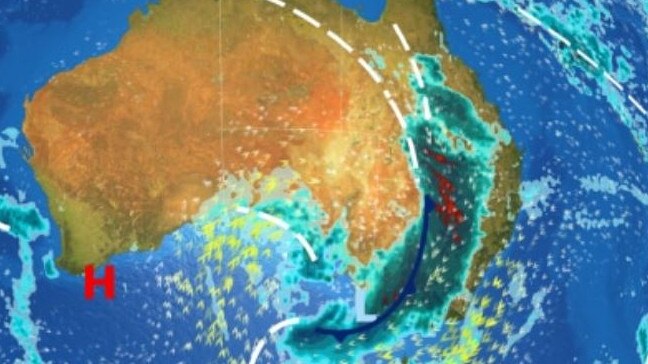
Severe storms are likely to pack a punch in central and southern parts of the state with the triple-threat of large hail, damaging winds and heavy rainfall on Thursday afternoon.
While Brisbane, the Gold Coast and Sunshine Coast will be spared the worst on Thursday, widespread rain totals of between 20-40mm and isolated falls of more than 60mm in a single day will fall over the already flooded catchments of the Murray-Darling basin.
The Bureau of Meteorology’s Helen Kirkup said Brisbane could see more than 20mm of rain on Friday if thunderstorms settle over the city.
“We’ve got a lot of rain coming in, especially tomorrow,” Dr Kirkup said.
“We could easily get 10 to 15mm. There’s a good possibility that if we get a thunderstorm there’ll be more than that, so we’re looking at more than 20mm in some places.”
“We are expecting thunderstorms to be quite widespread. There are a lot of thunderstorms happening in the west at the moment, so we’re going to see all of that heading towards Brisbane,” she said.
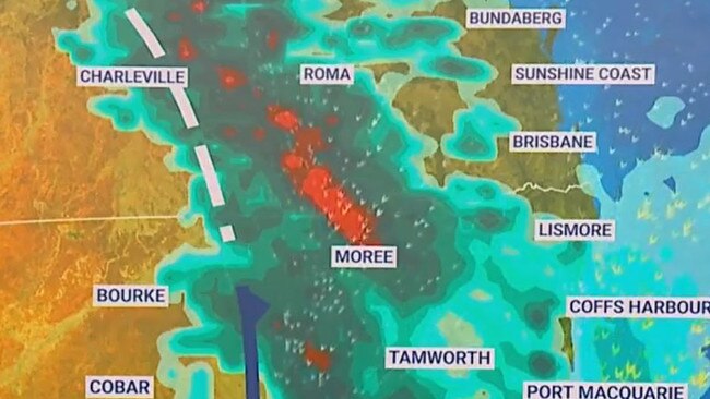
In the past day South Comongin in the Warrego region copped the most rainfall, with 44mm falling in the 24 hours to 9am Thursday.
Yappi Creek received 41mm, Patricia Park 38mm, Soonah Crossing 37mm, Humeburn 36mm, Quilpie 34mm, Cunnamulla 31mm, Bulloo Downs 31mm, Alroy Crossing 29mm, Cliffdale 28mm, Allambie 22mm, Autumnvale 21mm, Winbin Creek 21mm and Mariala National Park 20mm.
The Bureau is still determining how severe the storms over the Brisbane region will be, and Dr Kirkup advised the public to keep an eye on weather warnings.
After the wettest August for the region since 1985, widespread minor to moderate flood warnings are already in place with many dams full and minor roads closed.
Storms are possible for Brisbane on Friday as the rain band moves across land and out to sea, clearing in time for a weekend of sunny skies and warm spring weather.
Until then, residents in southern parts of the state should remain alert to local storm and flood warnings.
As of 9am Thursday morning, moderate flood warnings were in place for the Balonne River, Bulloo River and Paroo River; minor flood warnings for the Barcoo River, Cooper Creek, and Middle Dawson River; and a final flood warning for Diamantina River.
Read related topics:Weather

Monster weather system brings storm, heavy rain to Qld
Brisbane and surrounding parts of the southeast have been hit by storms and heavy rainfall this afternoon as a 3000km-long monster low moves across the state.
Read more

Wild storms, polar blast as 3000km monster low barrels towards Qld
The system, which stretches 3000km from north to south and encompasses 30 per cent of Australia, is forecast to pack a punch when it hits Queensland.
Read more