
Qld weather: Flash flooding alert as storms hammer SEQ
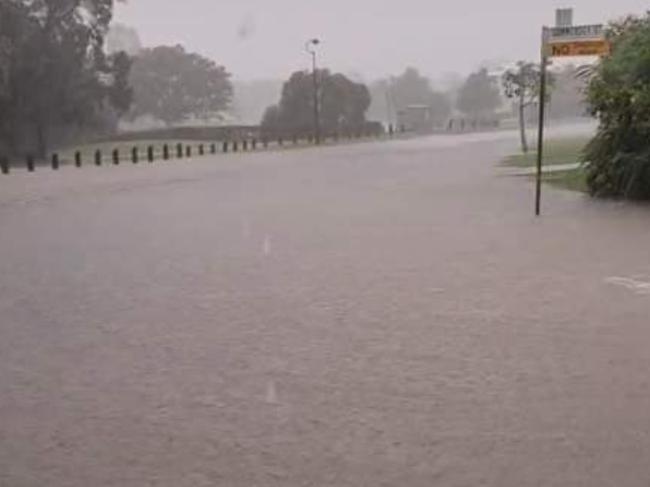
Slow-moving storms dumped 113mm of rain in one hour in Brisbane’s north Sunday evening, while a person had to be rescued by a sinking vehicle in flood waters.
QLD weather news
Don't miss out on the headlines from QLD weather news. Followed categories will be added to My News.
A north Brisbane suburb was pummeled by an intense and slow-moving storm overnight which dropped 113mm in just an hour.
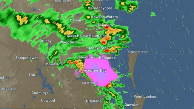
Bureau of Meteorology forecaster Harry Clark said Burpengary was the suburb the hardest hit overnight.
“Late yesterday afternoon we did get a fairly slow moving storm through the Burpengary, Narangba area,” he said.
“It managed to drop 129 millimetres (since 9am), it was very isolated in Burpengary.
“That part of Brisbane was very wet yesterday but for most other locations they generally got 10 millimetres yesterday.”
A person was also rescued from a sinking vehicle which had been caught in flood waters about 7.30pm on Sunday night.
Paramedics assessed the person, who declined treatment, after the incident at the corner of Old North Rd and Caboolture River Rd at Rocksberg, near Caboolture.
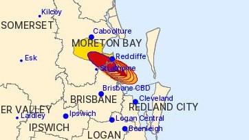
Earlier, the bureau had issued two severe thunderstorm warnings Sunday evening but cancelled both just before 6pm. The radar showed the heaviest rainfalls crossing the coast, headed out to sea, at 6pm.
At 5.31pm a warning for heavy rainfall was issued for people in parts of Brisbane City and Moreton Bay council areas.
“At 5.30pm, a severe thunderstorm likely to produce heavy rainfall that may lead to flash flooding was detected near Brighton, Kallangur and Narangba,” the warning said.
“This thunderstorm is moving towards the southeast. It is forecast to affect Redcliffe, Boondall and Sandgate by 6pm and Mud Island and central Moreton Bay waters off Redcliffe by 6.30pm.”
A more general severe thunderstorm warning, for heavy rainfall, had been issued at 5.15pm Sunday for people in parts of the southeast coast forecast district.
The warning said a trough was triggering slow thunderstorms producing heavy rainfall.
The alert slow-moving storms were near Redcliffe.
“Severe thunderstorms are likely to produce heavy rainfall that may lead to flash flooding in the warning area over the next several hours. Locations which may be affected include Redcliffe,” the warning said.
The BoM confirmed in its 5.31pm warning that 84mm of rain had fallen at Burpengary in just 30 minutes.
At 5.15pm it said thunderstorms, when near Narangba, had dumped 51mm of rain in the last hour.
The storms came after a forecasted drenching with flash flooding and a warning to reconsider travel plans had appeared to fizzle, with the southeast corner as of Sunday lunch time getting a fraction of the rain predicted to lash the region.
On Friday, the Bureau warned Logan, the Scenic Rim and the Gold Coast could see flash flooding with isolated falls potentially beyond 100mm.
However, the majority of the South East had received less than 30mm by lunch time Sunday.
The only exceptions were Oyster Creek in Burleigh Heads on the Gold Coast with 62mm in 24 hours to Sunday morning, and Double Island Point north of Noosa with 60mm.
Meteorologist Harry Clark said modelling late on Saturday had showed the Gold Coast could still be hit with 100mm on Sunday, insisting the situation was “incredibly finely balanced”.
“We’ve seen mostly light to moderate falls in South East Queensland, thankfully the possibility of heavier falls and thunderstorms stayed out to sea,” Mr Clark said before Sunday night’s storms.
“The system coming from the coast didn’t make it fully ashore, that’s why the highest totals were 60mm and not 100mm.
“The fact that the system stayed 10km out to sea made a difference, the heavy rainfall still occurred, but it was out to sea and not over land.”
Mr Clarke said the state’s South East should have “a fairly sunny week” from Monday, with dropping humidity and dry south-westerly winds bringing cooler mornings.
EARLIER: Satellite image that reveals stark change ahead for SEQ weather
Southeast Queensland is set for a huge change in weather this week, with rain set to clear and minimum temperatures dropping sharply.
The Bureau of Meteorology’s Harry Clark on Sunday morning said a series of crisp “roll” clouds moving across the western Darling Downs Sunday morning was connected to a broader change that will sweep across the southeast later in the day.
”This wet weather we’ve been seeing is coming to an end, we will see drier air pushing from the west later today,” he said.
“Next week it will be quite sunny, even quite cool, and feel quite autumnal from Tuesday onwards, that roll cloud is the marker of that change.”
Mr Clark said there would continue to be showers over central Queensland and the South East on Sunday, but said the feared overnight deluge had not eventuated.
“We didn’t get the heavy falls, more moderate falls so the highest totals have been a bit sporadic,” he said.
“Mount Joseph, which is in the Wide Bay, had 69 millimetres followed by Double Island Point which is Sunshine Coast had 60 millimetres and Oyster Creek which is just inland of Tallebudgera on the Gold Coast has had 60 millimetres as well.’
He said falls were between 10 and 20mm around Brisbane.
The Bureau of Meteorology and emergency services were involved in a media conference on Friday that urged people to reconsider travel plans amid the possibility of falls of 100mm.
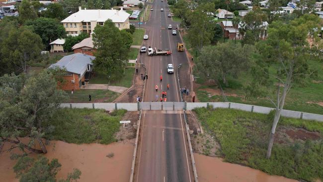
For the state’s southwest, Mr Clark said flooding was still a concern with a major flood level peak at Charleville on Saturday which would soon impact the Paroo Shire.
“Areas downstream, that includes Cunnamulla are going to see those major floodwaters, it is a fairly slow river system being that far west,” he said.
“So we’re likely to see the major flooding extend downstream over the next few days to Wyandra, which is expected to hit major flood level on Tuesday morning and Cunnamulla Bridge expected to go above major flood level later in the week.”
Mr Clark said there was less severe flooding elsewhere across the southern interior with a minor flood warning for the Moonie, Thomson lower Flinders, Norman, Georgina, Balonne and Barcoo Rivers.
There were also moderate flood warnings for the Eyre Creek and Weir River.
Join the conversation

‘Can’t be ruled out’: Potential for freak Qld snowfall this week
Queensland could see snow this week with weather models predicting up to 14cm falling on the Granite Belt.
Read more

Monster weather system brings storm, heavy rain to Qld
Brisbane and surrounding parts of the southeast have been hit by storms and heavy rainfall this afternoon as a 3000km-long monster low moves across the state.
Read more