
Thousands without power as supercell storms smash SEQ with heavy rain, wild winds, hail
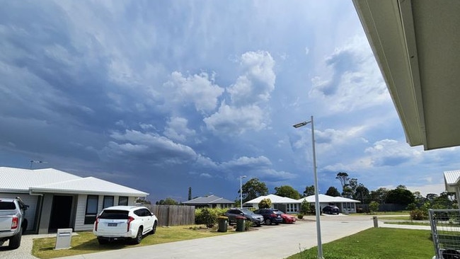
Brisbane, Moreton Bay and parts of Wide Bay are in the firing line for more severe weather this evening after the South East was smashed with supercell storms leaving 1000-plus without power.
QLD weather news
Don't miss out on the headlines from QLD weather news. Followed categories will be added to My News.
Severe thunderstorms have redeveloped with warnings for heavy rain, damaging winds and large hail for parts of South East Queensland.
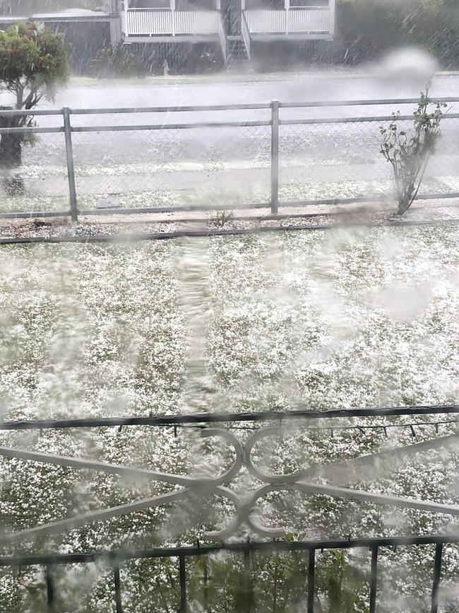
It comes after supercells smashed the region all afternoon on Tuesday, with more than 1000 properties without power and backyards turned white with hail.
At 7.16pm the Bureau of Meteorology issued a severe thunderstorm warning for heavy rain and damaging winds for Brisbane City and Moreton Bay.
Prior to that an identical alert was issued for the same regions at 6.25pm and for people in parts of Wide Bay, Burnett and South East Coast forecast districts.
While at the same time issuing an identical warning
It came after a severe warning at 5.12pm and at 6.05pm for people in parts of Sunshine Coast, Brisbane City and Moreton Bay.
The warning said that at 5.05pm a severe thunderstorm likely to produce damaging winds, large hailstones and heavy rainfall that may lead to flash flooding was detected near Caboolture and Beerburrum.
“This thunderstorm is moving towards the east. It is forecast to affect the area southwest of Caloundra, Bribie Island and northern Bribie Island by 5.35pm and waters off Caloundra, Comboyuro Point and waters off Bribie Island by 6.05pm,” the warning said.
Storms in Ipswich, Logan, Toowoomba and Brisbane had “temporarily eased” but the BOM said the redevelopment of severe thunderstorms there was possible.
A more general severe thunderstorm warning is also current for parts of the Wide Bay and Burnett, Darling Downs and Granite Belt and Southeast Coast districts.
More than 60,000 lightning strikes were recorded by 3.30pm, before properties across the region went dark.
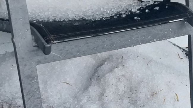
Reports have also emerged of hail up to 15mm in size and wind gusts at 80km/h.
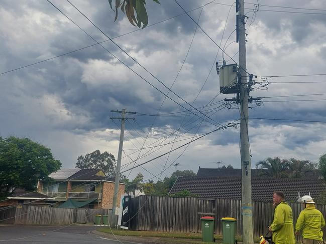
By 7.15pm there were 1412 Energex customers without power. Brisbane (19) Ipswich (161), Scenic Rim (1), Moreton Bay (259), Logan (161), Sunshine Coast (66), Noosa (2), Somerset (11), Lockyer Valley (279) and the Gold Coast (453).
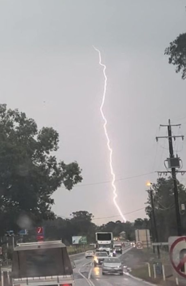
Energex senior corporate communication adviser Danny Donald had earlier said the lightning strikes were fairly intense.
“Looking at the radar I wouldn’t be surprised if we see more outages. We have crews on standby ready to go,” Mr Donald said.
“We have already had around 60,604 lightning strikes. The majority of those have been in the south Gold Coast, Scenic Rim, and Brisbane south. The rest of those around the Ipswich and Lockyer Valley.”
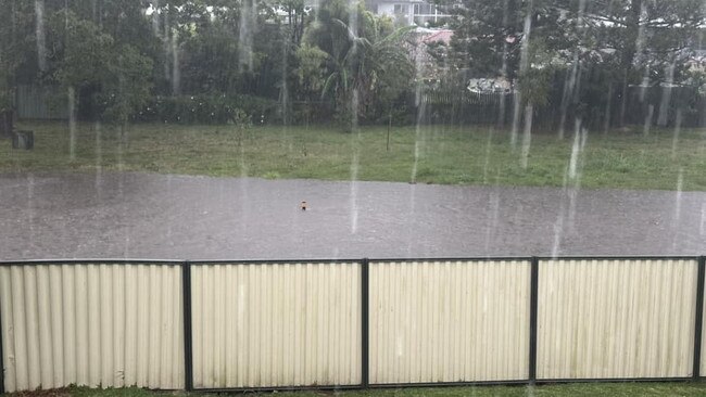
Rainfall totals reached more than 30mm in an hour, with Mount Nimmel in the Gold Coast hinterland recording 31mm.
Elsewhere, 29mm fell at Peak Crossing within the hour to 2pm, while 21mm fell at Harrisville during the same time frame. Marsden copped 15mm and Waterford 16mm in an hour, while Slacks Creek saw 13mm in the hour to 3pm.
The Queensland Department of Transport and Main Roads issued two flash flooding alerts on Tuesday afternoon.
At 4.48pm, Exit 19 Rochedale Road, Rochedale South was reported to have water over the road.
Lanes were reduced heading southbound towards Gold Coast, however, no delays were expected for motorists.
Parts of Brisbane’s west also experienced heavy rainfall causing the department to issue a flash-flooding alert in Durack. Bowhill Road was closed in both directions.
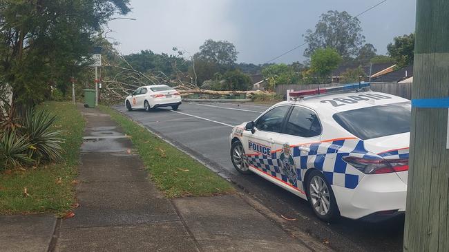
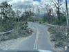
Logan was hit by pea-sized hail and heavy rain, with some roads blocked by fallen trees and power lines.
Queensland Police Service issued a traffic alert for commuters driving through Logan around 4pm.
Park Road between Marbella Street and Oriol Crescent in Slacks Creek was closed in both directions due to storm damage.
Motorists were urged to avoid the area.
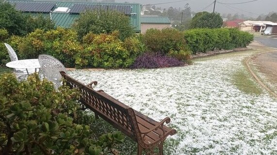
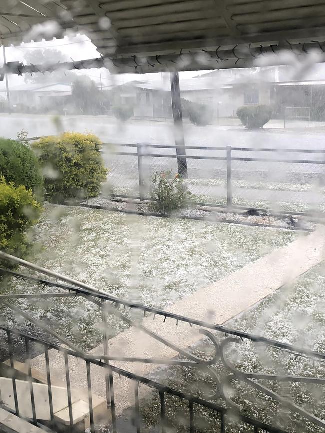
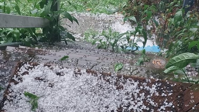
Backyards had earlier turned white after a hailstorm hit the Scenic Rim and Ipswich, while an aviary was sent flying by wild winds at Kooralbyn.
Boonah resident Renee Kirra said it looked like snow had fallen.
“We’re between Beaudesert and Boonah now but Boonah looked like a snow field and the bowls greens were flooded,” Ms Kirra said in the early afternoon.
Debbie Davidson posted pictures of hail blanketing a suburban Boonah street.
“Blimey,” she said.
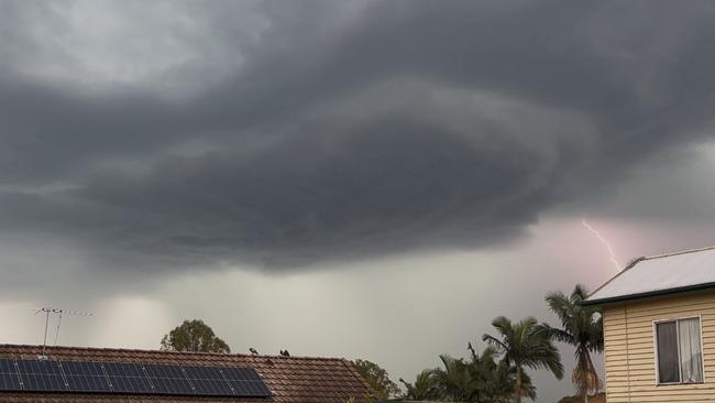
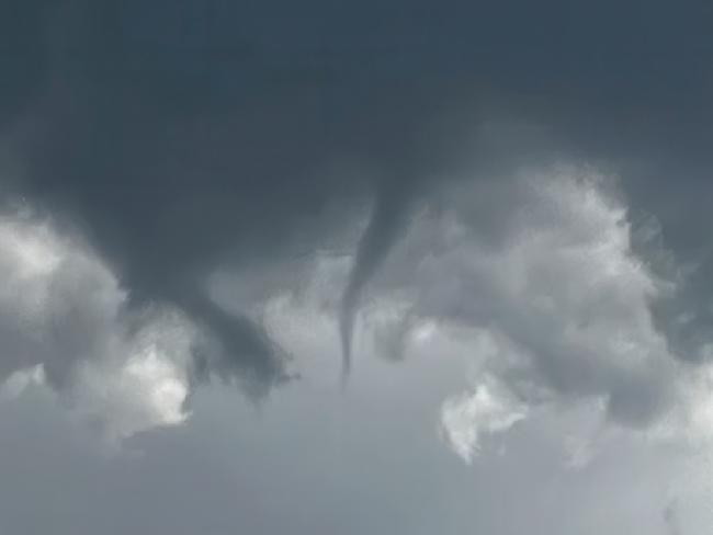
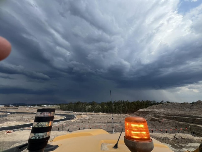
Senior meteorologist at the Bureau of Meteorology Christie Johnson earlier confirmed a number of supercell thunderstorms had moved through the region.
Ms Johnson added that the supercell thunderstorms had the potential to produce funnel clouds, with a potential sighting of a funnel cloud reported at Fairfield on Tuesday.
“Whenever we do have some supercell thunderstorms around that are rotating storms, there is the potential for funnel clouds,” she said.
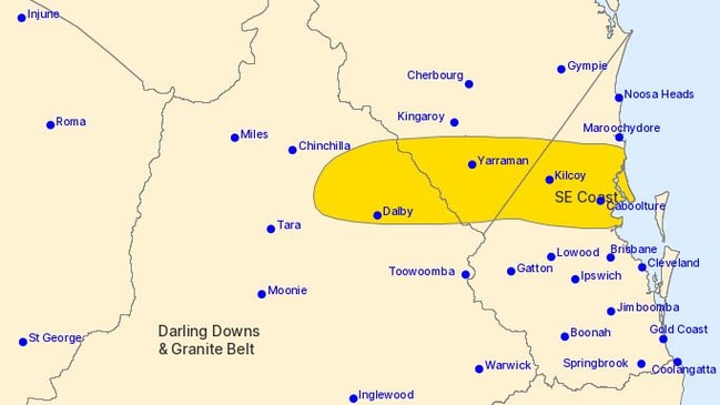
The separate, more general severe thunderstorm warning was updated at 4.41pm for heavy rainfall, large hailstones and damaging winds and remained active for people in parts of Wide Bay and Burnett, Darling Downs and Granite Belt and Southeast Coast forecast districts.
“An inland trough combined with a southerly change moving up the Southeast Coast in a moist and unstable air mass is producing severe thunderstorms this afternoon,” the warning said.
“Severe thunderstorms are likely to produce heavy rainfall that may lead to flash flooding, large hailstones and damaging winds in the warning area over the next several hours.
“Locations which may be affected include Dalby, Caboolture, Caloundra, Yarraman, Kilcoy, Nanango and Redcliffe.
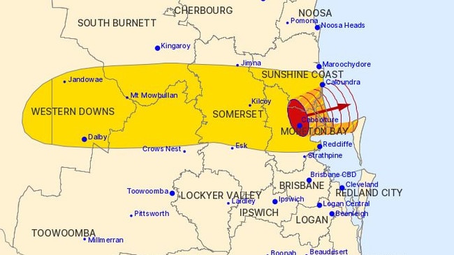
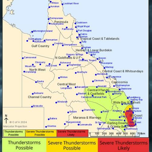
35,000sq km warning zone: Severe storm threat escalates
It comes after The Courier-Mail reported South East Queensland was under threat from severe thunderstorms today that could bring damaging winds and large hail, with the potential for heavy rainfall and flash flooding.
The new threat comes after a severe thunderstorm lashed Gympie and the Sunshine Coast on Monday, with hail almost 5cm in diameter and heavy rainfall with up to 44mm recorded.
Senior Meteorologist at the Bureau of Meteorology Angus Hines said storm season has well and truly commenced in Queensland.
“Storm season certainly has begun and we did see a little taste of that yesterday,” Mr Hines said.
“There was some pretty big hail reported around parts of South East Queensland yesterday, with hail four to five centimetres in size recorded.”
Mr Hines said the risk of severe thunderstorms today brings the potential for damaging winds over 90km/h and large hail over 2cm to areas.
“We do have the risk of severe storms stretching across the south east, the main threats today look likely to be damaging wind gusts and large hail,” he said.
“There is a possibility that we could see some areas or some pockets of heavy rainfall, which potentially could lead to areas of flooding right underneath those storms that do develop and bring some spells of heavy rainfall here or there across the South East
“The risk today is from about mid afternoon through until certainly the middle of the evening.”
Mr Hines said the severe thunderstorms today will be more widespread from this afternoon and cover several regions – an area of more than 35,000 square kilometres in size.
“We’re seeing the possibility of severe thunderstorms across parts of the South East as well as the Wide Bay Burnett area, and maybe just pushing up into the Darling Downs as well.
“So that could include areas like Gympie, then stretching down into spots like Oakey and Toowoomba, and then down across much of the southeast.”

Mr Hines said Brisbane appears to be on the cusp of the high risk area, with activity expected to be more prominent in land from the city.
“It looks a little bit more likely up in the inland parts of Brisbane and out to the west of the city there,” he said.
“The same thing for the Gold Coast, perhaps a little bit more likely in the Gold Coast hinterlands.”
Mr Hines said there is also the potential for severe weather on Wednesday, with a chance of heavy rain and flooding.
“So tomorrow, the focal point of the storms does look like it shifts a little bit northwards on Wednesday, so the main areas become the Wide Bay and Burnett potentially up into parts of the Capricornia, maybe about as far north as Rockhampton, and then inland through parts of the Central Highlands, as well as parts of the Darling Downs, where in Central and South East Queensland,” he said.
“Again, wind and hail could be a risk, but also we could see some areas of heavy rain and flooding on Wednesday.”


Why is it so cold? What about these winds? Your Qld weather questions answered
Multiple flights have been cancelled and temperatures have plummeted – so what does it all mean for Qld?

Strong winds, freezing temps as ‘cyclone bomb’ delivers parting shot
Wild winds have continued to smash South East Queensland, as icy blasts from the “cyclone bomb” hitting NSW and forcing the cancellation of multiple flights deliver more knock-on effects in the Sunshine State.