
Qld weather: Scorching temps, more storms to come after brutal conditions hit southeast
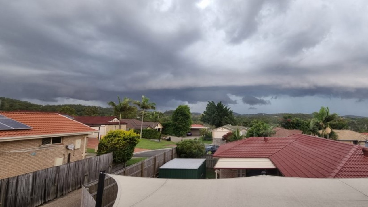
More severe thunderstorms are expected on Thursday after they slammed into South East Queensland overnight, bringing intense rainfall and leaving thousands without power.
Intense rainfall has lashed South East Queensland throughout the afternoon, dumping up to 73mm of rain in areas across the coast.
Residents copped a quick drenching across the coast with Pomona reporting 73mm of rainfall within a 30 minute period while Cooroy roads have reportedly been inundated with water after 63mm fell just before 5pm.
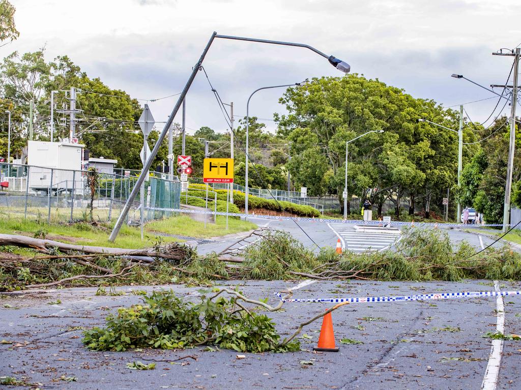
Queensland Police reported multiple traffic delays and traffic light outages throughout Wednesday as a result of the stormy weather including a blocked drain affecting traffic on Sandgate Rd northbound in Nundah and boom gates which have become stuck at Ferny Grove creating lengthy delays along Samford Rd and Abor St.
Police are asking motorists to use common sense when driving in wet conditions and to give way when necessary.
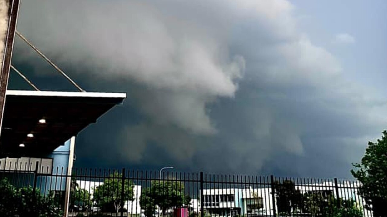
Severe storms passed through Brisbane and Logan earlier on Wednesday, with 26mm falling in Brisbane City in the space of an hour.
Meanwhile, Logan City copped 36mm in an hour, and Hillcrest recorded 51mm in just 30 minutes.
More than 5,300 were left without power in the state, predominantly Brisbane City residents which take up 2,241 of Energex recorded blackouts, followed by Logan City (1,794) and Moreton Bay (1,170).
Justin Coomber, spokesman for Energex said power technicians worked through the night to restore power to 30,000 homes after storms ravaged the South East on Tuesday.
He said Energex has crews on standby if the same level of outages was experienced on Wednesday night.
“So far today’s storm has been pretty quick but it was long and narrow and has affected the southern outskirts of Brisbane right up to the Sunny Coast,” he said.
“About half an hour ago we had 10,500 customers without power, we’re now down to 5,300.
“We aim to get power back for those people as soon as the cells pass and the crews can safely restore it.
“We’ll also be watching the next band of storms coming through and keeping a close eye on that, with crews on standby ready to go if needed.”
Storms were expected to continue overnight and into Thursday, affecting most of southern Queensland until the afternoon.
“Tomorrow is another wet day. Rain and severe thunderstorms are very likely,” BOM senior meteorologist Harry Clark said.
“Storm activity will start clearing from the south tomorrow afternoon, because of a strong southerly change which will move up the coast from the south, clearing out humidity and dropping temperatures and removing the risk of severe thunderstorms.”
The focus of the thunderstorms and showers will shift north of the Wide Bay on Friday, and north of Townsville on Saturday.
Meanwhile, tides could approach the highest astronomical tide for the year in the next few days across Queensland.
“Areas around the Gulf Coast and around the western side of the Peninsula and Torres Strait are likely to see the biggest impacts with possible inundation of low lying coastal areas due to the monsoonal surge persisting in the area,” Ms Pagel said.
If heavy rain in the south east coincides with high tides, this could exacerbate any potential flash flooding.
A reprieve to hot and muggy conditions in the southeastern corner are expected on Thursday as a strong southerly change brings a drop in temperatures.
Dew points are unusually high in the region, comparable to the average dew points in the Tropical North.
Minor to major flood warnings are current in the western, central and southern interior including the Gulf catchments.
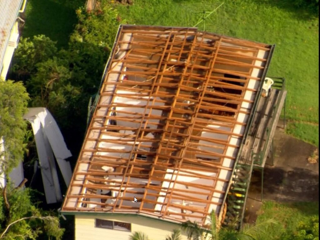
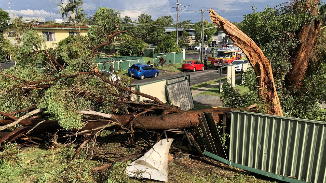
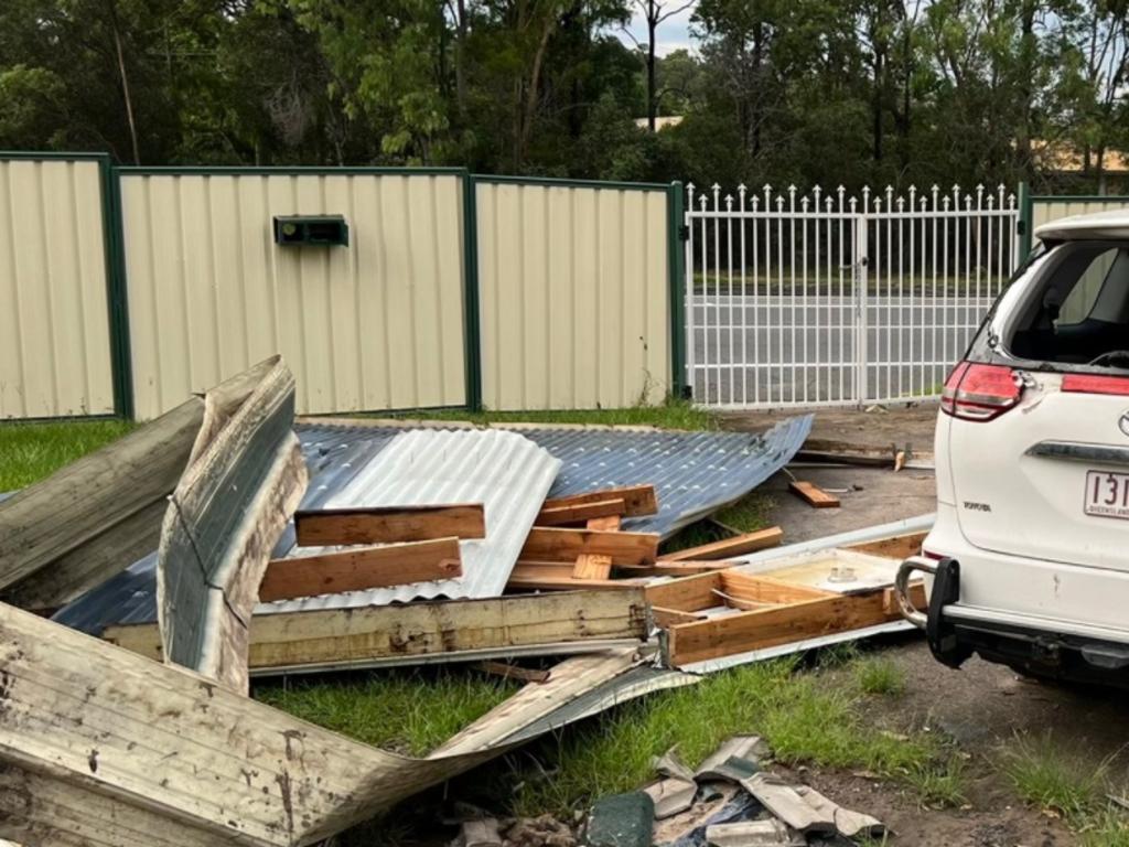
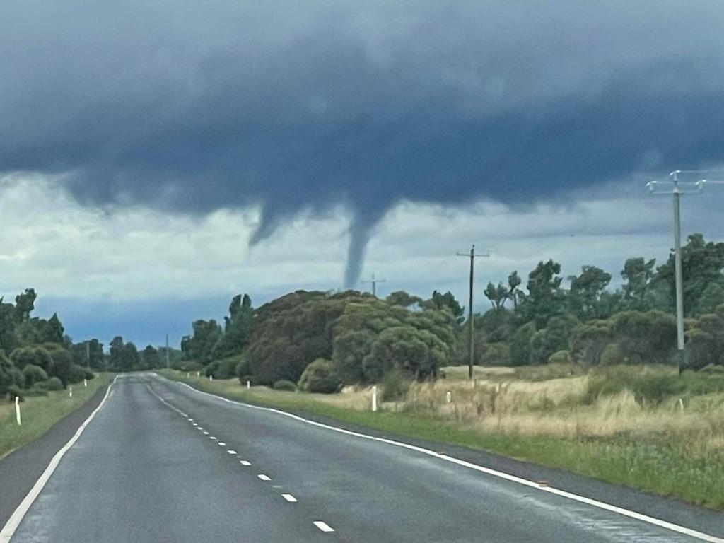
Hundreds of Logan residents on Wednesday woke to massive storm damage this morning after the supercell and mini tornado sliced across southwestern parts of the city on Tuesday afternoon.
Roofs were ripped from homes, cars destroyed and trees uprooted with the damage bill expected to be millions of dollars.
Shoppers at the Browns Plains Grand Plaza have told how they huddled in “hectic” crowds, panic purchasing umbrellas as the tornado tore through new shade sails on the top of the centre.
Muffin Break worker Marleen Sakarya was working an evening shift when the tornado struck the Plaza and said that things quickly turned “hectic” indoors.
“People were running around buying umbrellas, and huddling together,” she said.
“Never have I seen that many umbrellas and that much chaos.”
She said that shoppers saw the humour in the situation and despite a “hectic 30 mins”, shoppers were interacting as they huddled waiting for the rain to ease.
Ms Sakarya, who has been working at the cafe since 2018, said she always admired the greenery out there front door from her cafe but the sky was “completely white” from 4pm.
“The sky was as white as this napkin”, she said, pointing to the serviette on the counter.
She said that the noise was also “like nothing if ever heard” and immediately knew it was something stronger than a storm.
“The noise was crazy, just insane, it was so loud,” she said.
She said that traffic lights from the Plaza to her home in Loganlea, a 20 minute drive, were all out on her drive home after she closed shop at 5:30pm.
On her drive to work this morning at 6am, she said that the majority of the lights were still not working.
The soaring temperatures have forced the Australian Energy Market Operator to make an urgent call to the off-market for reserves to meet the demand for peak energy consumption.
Intense conditions are expected to ease by Friday as temperatures lower and the risk of thunderstorms ease.
“By Friday, we should be seeing some showers or two but no heavy thunderstorms,” said Ms Pagel.
Overnight temperatures are expected to drop to the low 20s by Friday evening before heading into a partly cloudy weekend.
CURRENT TEMPS & 7-DAY FORECASTS


