
Qld weather: Far North Qld monsoon returns as tropical low threatens to develop into cyclone
WHERE IT COULD CROSS: Parts of Queensland could be hit with a third tropical cyclone of a wild summer season, expected to make landfall within days.

QLD weather news
Don't miss out on the headlines from QLD weather news. Followed categories will be added to My News.
Queensland’s third tropical cyclone of a wild summer storm season could make landfall within days, the weather bureau has warned.
Far North Queensland is bracing for more wet weather as monsoon storms and a tropical low are expected to bring more rain to the already saturated region.
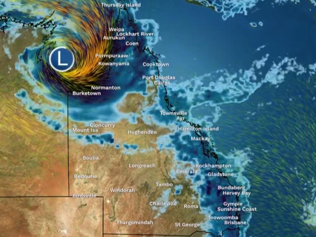
The weather bureau has warned the tropical low could this week develop into a third tropical cyclone, following ex-TCs Jasper and Kirrily.
The Bureau of Meteorology on Monday forecast severe isolated thunderstorms containing heavy rain and damaging winds in the state’s west and northern pockets, near Charleville and south of Winton.
A weak trough persisting over western parts of the state triggered unsettled conditions while a high pressure ridge over eastern and southern Queensland will persist throughout the week, bringing onshore showers to the east coast, the bureau said.
Mornington Island Airport in The Gulf Country had recorded 16mm of rain at 1pm while on the North Tropical Coast at Low Isles 19.2mm had been recorded.
The bureau expected another weak trough across the Peninsula and Gulf of Carpentaria to develop into a monsoon trough midweek.
Meanwhile, a tropical low located in the western Top End of the Northern Territory may form on Tuesday or Wednesday and drift east into The Gulf of Carpentaria by midweek.
There is a risk the tropical low, 07U, could develop into a cyclone from Wednesday, with chances increasing to moderate by Thursday and peaking at 35 per cent on Friday, according to the bureau’s tropical cyclone forecast.
07U could move towards the southwest later in the week with a risk of it making landfall across the southern coastline of The Gulf of Carpentaria.
Forecasters warned the combination of the monsoon trough and tropical low will increase rainfall around Far North Queensland from Thursday.
The South East will also face more wet weather with the chance of showers across Monday and Tuesday escalating to the chance of thunderstorms on Wednesday and Thursday.
Forecaster Harry Clarke said any future rain would intensify flooding about the state’s west and far northwest near Burketown.
“It’s ongoing from the previous system, we still have those floodwaters going down the western Queensland’s rivers,” he said.
“And there’s still severe flooding ongoing in the far north west of the state at the Flinders and Nicholson rivers.”
Mr Clarke said any further heavy rainfall from the monsoon system or tropical low would lead to renewed flooding in those areas.
“That’s a significant watch point, particularly that north west about the Burketown, Doomadgee Gulf Country area,” he said.
“The other area we could get some isolated heavy falls on the East Coast, basically north of Townsville, that one is not as certain, potentially not until around Friday or Saturday.”
The forecaster said while the tropical low was not likely to develop into a cyclone, it would still drift south and cross the southern Gulf Coast later in the week.
“It’s going to bring some very heavy rainfall regardless of how strong it is,” he said.
“The heavy rainfall in the northwest is somewhat tied in with that tropical low coming down towards the southern Gulf coastline.”
Mr Clarke said people in the states the southeast could expect isolated showers over coming days.
“Nothing heavy or widespread, just a couple millimetres here and there, potentially increasing a little bit from Thursday,” he said.
“Temperatures are looking pretty average for this time of year, around 22 to 30 degrees in Brisbane the next few days.”
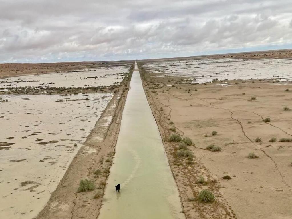
It comes as the owner of the William Creek Hotel in South Australia, 720 kilometres from Birdsville, was able to get a bird’s eye view of the inland sea created by ex-Tropical Cyclone Kirrily’s flood waters flowing toward Kati Thanda-Lake Eyre.
“The water last year was a drop in a bucket compared to this, and they’re still getting rain,” he said.
“To see it from 3500 feet really showed the enormity and extreme amount of water.”
More Coverage


Ice ice baby: Spectacular images of unseasonal frost as Qld freezes
Queensland’s overnight temperatures will increase to double digits in the coming days, following the coldest start to winter in 16 years, bringing frost and ice to many regions. SEE THE PHOTOS

City’s coldest June start in 16 years, feels like MINUS 9.8C out west
Southeast Queensland is shivering through its coldest morning in more than 15 years but feels-like temperatures have dropped to insane levels in the southern inland.