
Qld weather: Driver trapped in floodwaters, huge falls forecast for state’s far north and west
A person has been rescued from floodwaters in the Sunshine Coast hinterland overnight, as Queensland prepares for days of ‘incredibly heavy rain’.
QLD weather news
Don't miss out on the headlines from QLD weather news. Followed categories will be added to My News.
A severe weather event set to saturate large parts of Queensland over the coming week could make for the wettest May on record, with Premier Annastacia Palaszczuk warning people should prepare for “incredibly heavy rain”.
It came as a motorist was rescued from floodwaters in the Sunshine Coast hinterland overnight after a storm passed through the area.
The male driver was trapped in their car near Cookes Rd Bridge about 7pm on Friday after the storm dumped 35mm on nearby Conondale and nearly 80mm on Maleny.
Emergency services had difficulty reaching the person as the bridge was underwater, but he was rescued by about 10pm with no medical attention required.
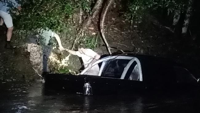
A witness said the man attracted attention by banging on the roof of his car.
Rescuers had feared for the worst.
Ms Palaszczuk on Friday told Queenslanders to brace for a wet weekend, particularly in the far north and western parts of the state, before rainfall was expected to ramp up early next week.
The weather bureau has forecast up to 250mm falling on parts of north Queensland, including Townsville, over the next five days.
Ms Palaszczuk urged Queenslanders to plan ahead for severe weather.
She said Local Government Minister Steven Miles had contacted relevant mayors to make sure they had plans in place,
“We do not expect this severe weather to be as intense in southeast Queensland, so that is a relief, however we will be monitoring it very carefully, and of course some of the streams and rivers have been saturated from our earlier weather event,” Ms Palaszczuk said.
“It is very unusual to see this type of situation occurring in Far North Queensland especially this time of year, which is usually near the end of the season, and we are expecting higher rainfall totals than we’ve seen before in May.”
Meteorologist David Grant said the average May rainfall for many towns across north and western Queensland was about 10mm to 20mm, so totals forecast were “very rare”.
He said the rain came on the back of recent wet weather over a widespread area about a fortnight ago.
“So this rainfall at this time of year over such a wide area, in conjunction with recent rainfall and saturated catchments, means that any of the small catchments will be very responsive with a heightened flash flood risk,” Mr Grant said.
“But also where we’ve got current or recent flooding, that will be more prone to renewed rises.”
Several flood warnings were ongoing on Friday evening including a major flood warning for the Cooper Creek at Windorah.
The focus of the impending severe weather is expected to be around Townsville, Ingham, Longreach, Winton, Longreach, Windora and Barcaldine where a sheep station last week recorded its highest daily total in 83 years.
Marcelle Chandler, from Home Creek, said over 200mm in the rain gauge in late April meant farmers around Barcaldine, previously desperate for rain, wouldn’t have to sell off more stock or buy in hay.
While they would welcome more widespread showers, Ms Chandler said the potential for another 200mm was a concern.
“We don’t want that again because all the waters ways are still full so rain like that again would be devastating,” she said.
“We might even get some stock losses because they can get bogged and it would be just too muddy for the sheep especially.”
Some farmers in the area had begun moving stock and machinery to higher ground.
The weather bureau has advised severe thunderstorms with heavy rainfall and damaging winds were possible from Carmila, near Mackay, right down to Noosa.
Mr Grant said South East Queensland wasn’t “totally out of the woods” and would also see an increase in showers and storms from this weekend.
“In terms of widespread rainfall, at this stage it’s looking less likely,” Mr Grant said.
He said there was still a risk of flash flooding for the southeast with locally heavy showers, given the wet season the southern corner had had.
The bureau has forecast 60mm to 130mm falling on Brisbane over the next five days.
Low-flow releases are planned from Somerset Dam into Wivenhoe Dam over the next three days.
The releases are not expected to cause the lake level in Wivenhoe Dam to increase by more than 0.5m during the three-day period.
Low-flow operational releases subsequently increased from Wivenhoe Dam from Friday afternoon to manage water levels.
Emergency Services Minister Mark Ryan said a response was already under way, with planning by Queensland Fire and Emergency Services, police and councils.
“But we do need the co-operation of Queenslanders,” he said.
“So I’m asking Queenslanders to do what they would do usually … which is watch for the weather conditions, do not enter floodwaters.”
He said residents who usually might need to stock up on supplies during the wet season, should do so.
Queensland Police Commissioner Katarina Carroll said 14 people died during the state’s previous weather event.
“And a lot of that was people driving through flood waters or being caught in flood waters obviously rising,” she said.
“So I ask that you prepare now, that you plan your trip and as you’ve already heard, I’ll reiterate that message, please do not drive through floodwaters.”
The Commissioner said there may be issues with supply across the state but there were systems in place to address the issue.


‘Can’t be ruled out’: Potential for freak Qld snowfall this week
Queensland could see snow this week with weather models predicting up to 14cm falling on the Granite Belt.

Monster weather system brings storm, heavy rain to Qld
Brisbane and surrounding parts of the southeast have been hit by storms and heavy rainfall this afternoon as a 3000km-long monster low moves across the state.