
Qld weather: Cyclone watch, SEQ temps to plunge, coastal areas warned of monster surf
The Bureau is back on cyclone watch as a low pressure system forms in the Coral Sea, while southeast Queensland temperatures are expected to plunge and coastal areas remain on alert for strong winds and monster surf.

QLD weather news
Don't miss out on the headlines from QLD weather news. Followed categories will be added to My News.
The Bureau of Meteorology is back on cyclone watch this week with a low pressure system forming in the Coral Sea, while in southeast Queensland temperatures are expected to plunge as coastal areas remain on alert for strong winds and monster surf.
The BoM’s Patch Clapp said that while the low pressure system had only a 10 per cent chance of becoming a Tropical Cyclone, residents were still advised to stay across updates.
“We have a couple of low pressure systems in the north of the state. We do know that a tropical cyclone season does last until the end of April so we aren’t entirely in the clear yet,” Mr Clapp said.
“At this stage it is not looking like the systems will turn into a tropical cyclone, or even hit land as most of it will fade out over The Gulf of Carpentaria and northern parts of the Coral Sea.
“Our projections are predicting a 10 per cent chance of it forming into a tropical low. People should still stay over the watch points and stay up to date if it does turn into anything major.”

Early BoM indicators forecast the low pressure system, which has been named Tropical Low 13U, to form along a trough in the far northern Coral Sea, near Louisiade Archipelago Papua New Guinea mid to late in the week.
The low then may initially move to the south in the middle of the week, before moving westwards towards Cape York Peninsula over the weekend.
In the state’s south, Brisbane, the Sunshine Coast, Gold Coast and much of the western interior are forecast to be hit with a week of cooler temperatures.
“Most notably, a lot of Southeast Queensland will be hit with cool and dry south, south-westerly winds,” Mr Clapp said on Tuesday.
“It will be the first real taste of autumn conditions. We will have cooler overnight temperatures even starting from tonight and into tomorrow.
“Around Brisbane, minimum temperatures will be around that 14C to 15C, and even cooler further away from the coast in the Darling Downs and Granite Belt regions which are expected to hit single digits.
“It has definitely been a few months since we have seen anything this cool and on top of that the air will be drier which will help clear out the humidity that we have seen for much of the year.”
In the west, both Stanthorpe and Warrick are forecast to hit single digits.
“Stanthorpe is usually the first to go quite cool when we have a cold snap,” Mr Clapp said.
“Both Warrick and Stanthorpe will sit around 6C to 7C even from tonight and into tomorrow. Maximum temperatures are also expected to drop a few degrees as well.”
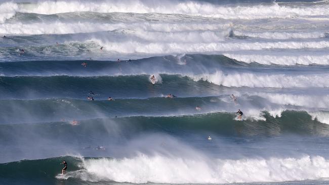
As well as cooler maximum temperatures, southeast coastal cities have been warned of strong winds and high swells over the coming days.
“Strong wind warnings have been issued from the Gold Coast up to the Sunshine Coast, so if people are preparing to be out on the water this week it is definitely something to take into account,” he said.
More Coverage


Monster weather system brings storm, heavy rain to Qld
Brisbane and surrounding parts of the southeast have been hit by storms and heavy rainfall this afternoon as a 3000km-long monster low moves across the state.

Wild storms, polar blast as 3000km monster low barrels towards Qld
The system, which stretches 3000km from north to south and encompasses 30 per cent of Australia, is forecast to pack a punch when it hits Queensland.