
Qld weather: Hail, heavy rain as storms track across southeast
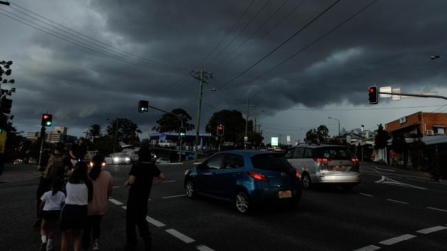
Parts of southern Queensland have been hammered by heavy rain and hail, with all storm warnings cancelled after another afternoon and evening of wild weather.

QLD weather news
Don't miss out on the headlines from QLD weather news. Followed categories will be added to My News.
Parts of southern Queensland have been hammered by heavy rain and hail, with all storm warnings cancelled after another afternoon and evening of wild weather.
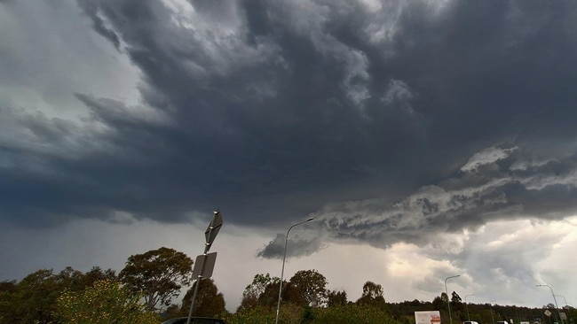
The Bureau of Meteorology cancelled a severe thunderstorm warning for Gympie, Somerset, South Burnett and the Sunshine Coast at 6.20pm after several small cells moved through the region.
The Bureau had issued a storm warning just before 5pm and again at 5.40pm the same areas, while a severe thunderstorm was about 5pm situated east of Kingaroy, tracking to the northeast.
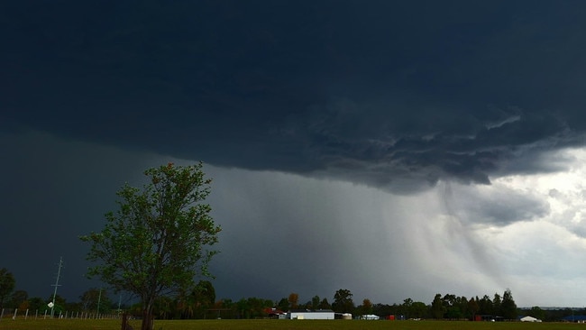
Heavy rain and small hail fell at Meandarra on the Western Downs.
The Bureau said the slow-moving trough in the state’s interior created a “moist and unstable” environment.
TODAY's thunderstorm forecast: Storms are broadly possible across #SEQld today.
— Bureau of Meteorology, Queensland (@BOM_Qld) October 16, 2024
SEVERE storms are possible in the southeastern interior of Qld today. DAMAGING winds & LARGE hail possible, and likely in southern Darling Downs.
For warnings please check https://t.co/CQJkcamqzO. pic.twitter.com/0sOJwroQoR
On Wednesday morning, there were some active thunderstorms between Goondiwindi and St George.
The storms come a day after Brisbane was smashed with thunder and lightning, while areas of the Gold Coast received 28mm of rain in just 10 minutes as afternoon storms swept through on Tuesday.
However, there is a severe thunderstorm risk for the Darling Downs and Granite Belt this afternoon, with a chance of locally destructive winds.
Bureau of Meteorology forecaster Patch Clapp said strong wind gusts are going to be on the cards for the region.
“The winds are going to be the watch point out through the Darling Downs and Granite Belt,” Mr Clapp said.
“Potentially we could see some locally destructive winds as well, so up to 125 kilometre an hour winds are on the cards for parts of the Darling Downs and the Granite Belt.
“We’ve got some watch points of damaging winds and large hail through the interior.”
Mr Clapp said the strong winds could also flow through to other parts of the state.
“Some of those winds are possible through parts of the southeast coast, also parts of the Sunshine Coast hinterland and through the South Burnett as well, with a couple of watch points for heavier rainfall at times through those parts as well,” he said.
There is no rain or storms forecast for the rest of the week, but high temperatures are expected with 33C forecast for Brisbane on Saturday.
The Bureau of Meteorology is also conducting routine testing today, from 9am to 5pm AEST for Tropical Cyclone warnings and the Tsunami warning system.
Test products will be marked as ‘TEST’ and appear for short periods of time on the Bureau’s website and BOM Weather app.
It comes after a band of rain and storms swept over southeast Queensland on Tuesday afternoon bringing thunder, lightning and sudden downpours.
Areas of the Gold Coast have reported receiving 28mm of rain in just 10 minutes as the line of short, sharp storm fronts – not severe enough to spark a BOM warning – hit the southeast.
Several flights were diverted from Brisbane Airport on Tuesday afternoon due to lightning strikes, delaying departures for at least an hour.
Between 5.30pm and 6pm, seven domestic flights were diverted to the Gold Coast, as well as four international services.


Feels like -5.3C: Icy blast sends temps plummeting again
South East Queensland has again shivered through a freezing start to the day, as a brutal cold front continues to blast the region with subzero temperatures, made worse by chilling winds.
Read more

Feels like MINUS 7.1C: Brutal cold front blasts southern Qld
A brutal cold front is blasting across southern Queensland with subzero temperatures and widespread frost.
Read more