
Brisbane storm: Triple front brings hail, flooding, power outages
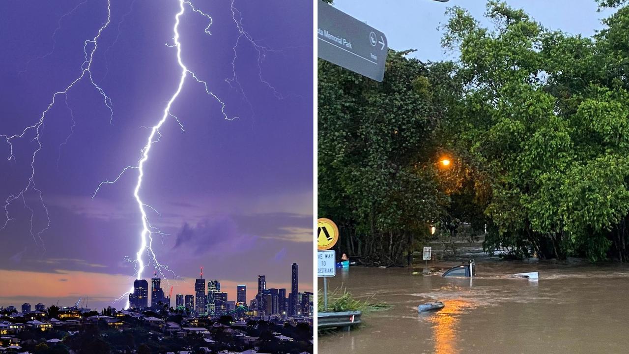
More than 10,000 homes were without power and a major store’s roof caved in after wild storms smashed into southeast Queensland, with more than 100,000 lightning strikes and widespread flash flooding.
QLD weather news
Don't miss out on the headlines from QLD weather news. Followed categories will be added to My News.
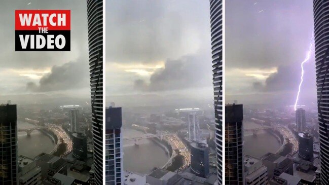
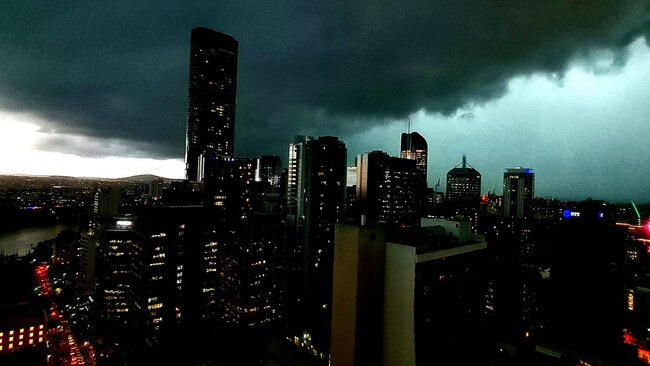
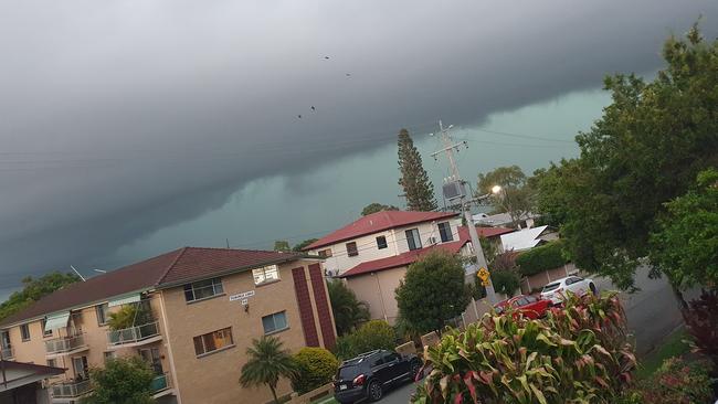
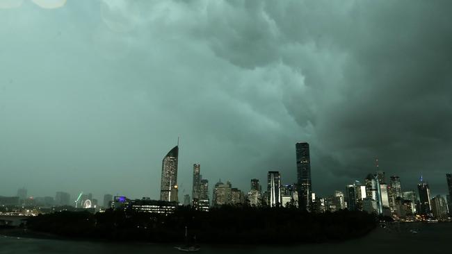
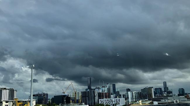
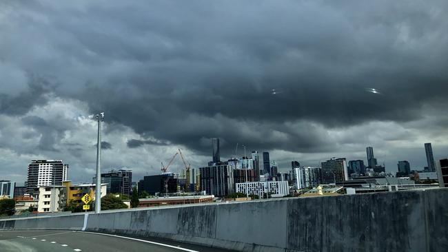
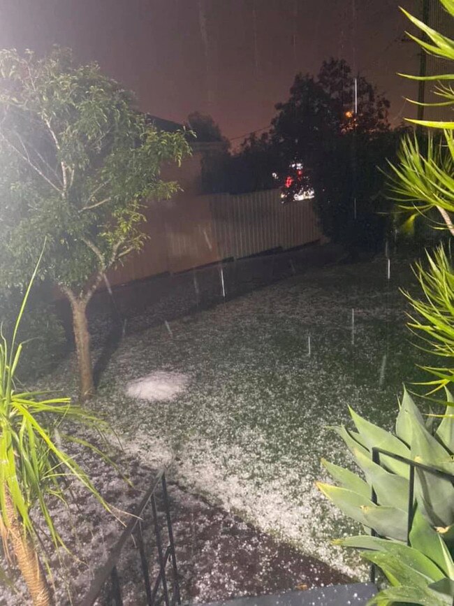
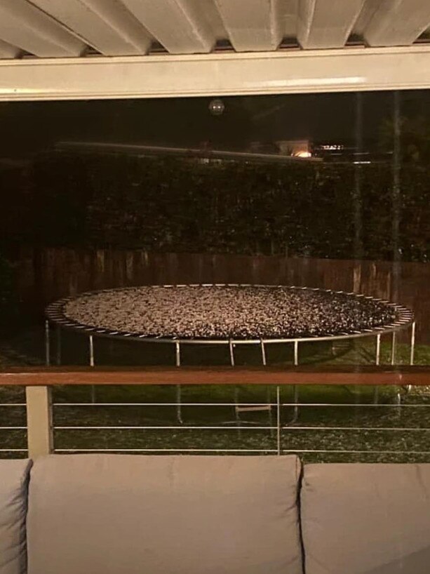
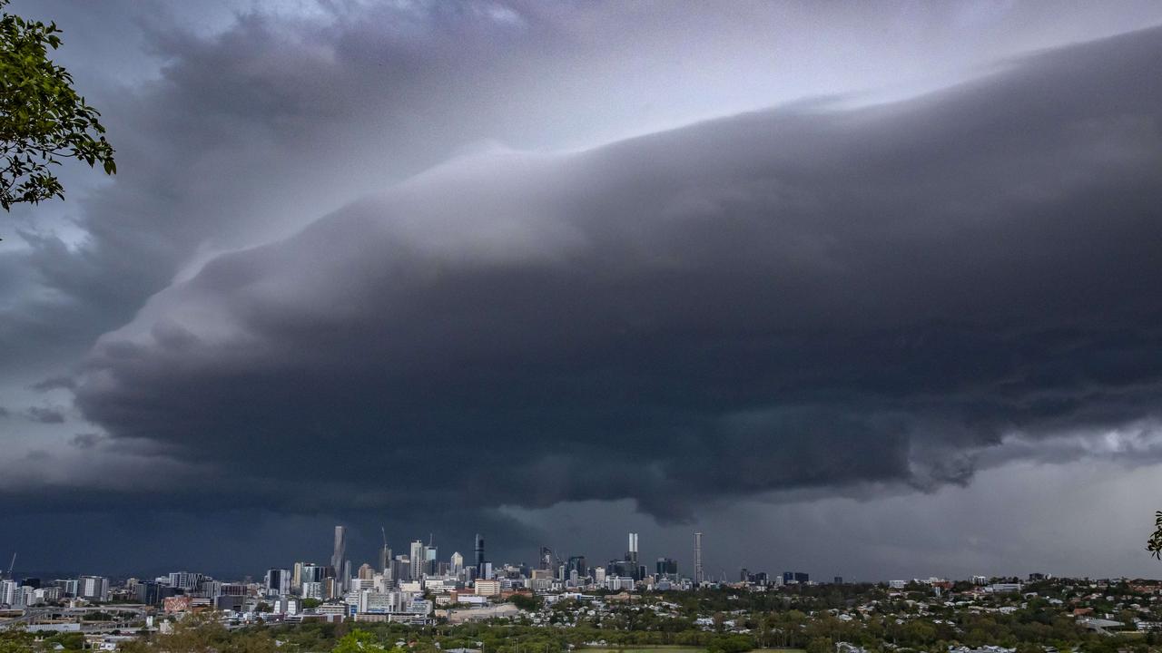
Southeast Queensland was smashed by severe thunderstorms on Wednesday evening, with giant hail, 100,000 lightning strikes, flash flooding and damaging winds.
Brisbane’s peak-hour traffic was thrown into chaos with suspended trains, traffic light outages, flash flooding and hour-long delays to commuters through key inner-city routes.
Energex reported about 11,000 properties without power at 6.30pm, most on the Sunshine Coast.
Flash flooding was reported across Brisbane, with at least two vehicles caught in floodwater at Moorooka.
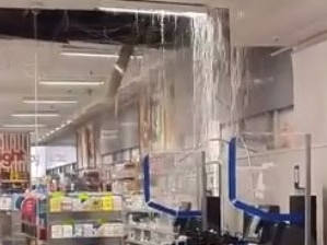
Footage has emerged from inside a popular store at the Sunshine Plaza shopping centre in Maroochydore showing the roof gushing water after hail and wild storms lashed the Sunshine Coast.
Sources confirmed that Kmart’s roof had collapsed and the store was reportedly filling with water.
It’s understood Kmart was evacuated and closed to shoppers.
Wild scenes inside Kmart in #Maroochydore earlier tonight.
— Jacob Chicco (@JacobChicco) May 12, 2021
Water was pouring through the store after the roof caved in. @10NewsFirstQLD
🎥 Leah Whittaker pic.twitter.com/raeKxwUF2F
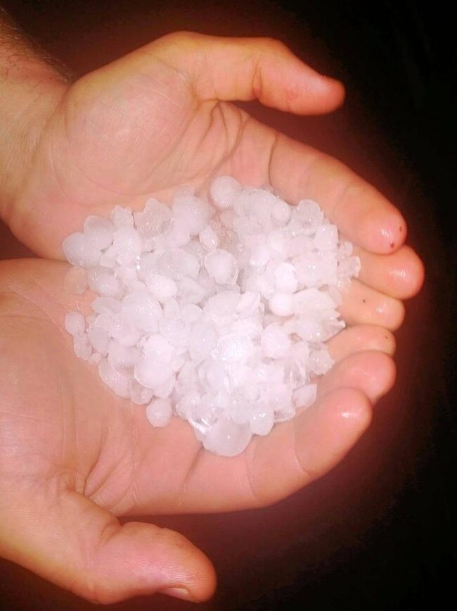
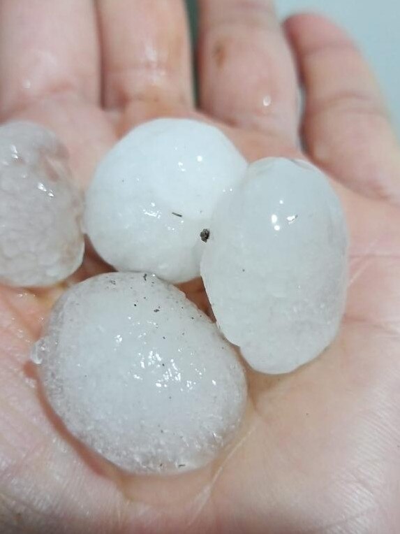
Giant hail was reported northwest of Brisbane at Esk, Toogoolawah, Mt Mee and Biarra.
Between 30-50mm of rainfall was recorded within 30 minutes in several areas, including Wynnum on Brisbane’s bayside and Toowoomba.
As of 11pm trains between Brisbane City and Beenleigh were still suspended due to storm-related problems with overheard power lines. Buses were operating.
TransLink said services were returning to normal on lines to Cleveland, Shorncliffe, Redcliffe, Caboolture, Sunshine Coast and Brisbane Airport.
Earlier it warned of hour-long delays to buses along Coronation Drive and Milton Rd owing to traffic congestion.
The severe weather comes after thunderstorms ravaged the southeast on Tuesday.
While storms are expected to clear for the coming days, a cold snap will sit over the southeast this weekend, with 14C minimums forecast on Friday, dropping to 10C on Monday.
Motorists were being advised to seek an alternative route and avoid Coronation Drive and Milton Rd.
All buses travelling through Brisbane’s CBD are experiencing 20-minute delays.

Two vehicles have been caught in flash flooding in Salisbury at the intersections of Evans
Road and Orange Grove Road.
Diversions have been set up via Beaudesert Road outbound from Moorooka heading towards Ipswich.
There are also road closures at Muriel Ave in Rocklea owing to flash flooding.
Actually carnage at our house #bnestorm#brisbaneweatherpic.twitter.com/MW9L99GRfG
— Brittanie Dreghorn (@Brittanieanne_) May 12, 2021
Traffic lights are flashing yellow at the intersection of Ipswich Road and Annerley Road, at the intersection of Inala Ave and Serviceton Ave, at Fairfield Rd and Ashby street, at Kingsford Smith drive in Eagle Farm.
Congestion through Brisbane’s CBD has slightly improved with delays to public transport and other motorists downgraded from an hour to 45 minutes.
"If it's flooded, forget it"
— 10 News First Queensland (@10NewsFirstQLD) May 12, 2021
Cars are taking their chances through flash flooding at Moorooka this afternoon where heavy storms have caused peak hour chaos on Ipswich Rd. #BneStormpic.twitter.com/bx1YLOL6FS
The Bureau of Meteorology warned at 5.30pm that severe thunderstorms were recorded near Cleveland, Palmwoods, Nambour, Mapleton, Montville and northern Moreton Bay.
Thunderstorms are moving east towards Maroochydore, Noosa Heads, and Eumundi.
Sunshine Beach is due to be hit by thunderstorms at 6.30pm.
The next warning from the Bureau is due around 6.30pm.

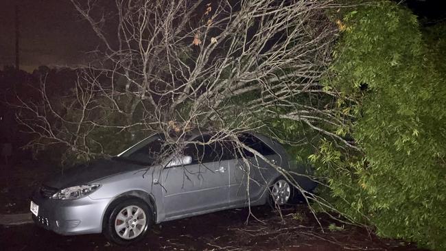
A tree has fallen on a car on Tristan Street, Carindale, but no one was injured in the incident.
Ipswich Road has reopened after flash flooding earlier this afternoon.
Traffic lights are out, flashing yellow, on Ipswich Road near Junction Terrace.
There is so much rain in this #bnestorm that it is coming through the seams of the bus I'm on pic.twitter.com/w5e9rbjBhV
— Brian MacNamara (@BMac_TLDR) May 12, 2021
Trains have been affected between Roma Street and Yeerongpilly due to power line outages.
A train heading southbound on the Beenleigh line, near Park Road, was stationary due to the power outages around 5.30pm.
There are power outages at the South Brisbane train station, which may affect commuters with delays to trains outbound from the city.
More flash flooding has occurred in the Moorooka area, with southbound lanes blocked at Beaudesert Rd by Police, diversions are in place.
#bnestorm brisbane right now pic.twitter.com/ysiMbN6rMA
— Morgan (@muddagen) May 12, 2021
Emergency services are urging motorists to drive carefully and reconsider travelling while the storms are ongoing.

Bureau of Meteorology senior forecaster, Peter Markworth, said that the risk of ‘giant hail’ has passed, with heavy rainfall posing the most significant threat as the storms pass across the southeast corner.
Rainfall figures are starting to come in as the system moves across the CBD.
Rainfall totals reached 30-40mm within 30 minutes, but those were expected to increase due to the rapidly moving cells.
A spokesman for Energex said 3600 homes were without power around Inala and Oxley and near Caboolture.
The spokesman said they were recording around 23,000 lightning strikes an hour in the Greater Brisbane area around 5pm.
The Bureau of Meteorology warned that, at 4.30pm, very dangerous thunderstorms were detected on the weather radar near Caboolture, Lake Samsonvale, Dayboro and Wamuran.
The thunderstorms were moving towards the east.
Very dangerous thunderstorms were forecast to affect Strathpine, Redcliffe, Beerburrum and northern Bribie Island by 5pm and northern Moreton Island, Comboyuro Point, Cape Moreton and waters off Bribie Island by 5.30pm.

Other severe thunderstorms were detected on the weather radar near Jimna, Wacol, Upper Brookfield, Enoggera Reservoir and Greenbank.
They were forecast to affect Brisbane CBD, Beenleigh, Logan City and Borumba Dam by 5pm and Cleveland, Nambour, Mapleton and Yandina by 5:30pm.
Giant hailstones, destructive winds and heavy rainfall that may lead to flash flooding are likely.
Hail 5cm in size was reported south of Toogoolawah at 3.20pm.
It came after a very dangerous storm has seen giant hail smash into areas near Esk. It is tracking northeast and is forecast to hit Somerset Dam, Toogoolawah and Lake Somerset by 3.45pm and Kilcoy, the area west of Kilcoy and Mount Mee by 4.15pm.
Giant hailstones, damaging winds and heavy rainfall that may lead to flash flooding are likely.
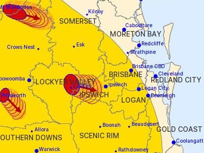
Earlier, a severe storm warning was issued for parts of Ipswich, Somerset, Scenic Rim, Toowoomba and Lockyer Valley council areas about 2.40pm.
Storms producing damaging winds, large hailstones and heavy rainfall that may lead to flash flooding are moving east.
They were forecast to impact Laidley, Gatton, the area west of Esk and the area northwest of Esk by 3pm and Esk, northern Lake Wivenhoe, Somerset Dam and Toogoolawah by 3.30pm.
The Bureau of Meteorology is urging people in the “impact zones” to “take action to stay safe”.
Take action to stay safe with damaging winds, large hail & heavy rainfall, which may lead to flash flooding, possible in impact zones of Severe Thunderstorm Warnings in southern parts of Queensland. Follow @QldFES advice. #QLDweather warnings https://t.co/WE4NwbRMV9pic.twitter.com/efBuwn4Pql
— Bureau of Meteorology, Queensland (@BOM_Qld) May 12, 2021
According to BOM, severe thunderstorms could potentially develop along a line between Rolleston and Warwick.
Locations likely to be impacted include Warwick, Toowoomba, Brisbane, Gympie, Ipswich, Kingaroy, Caboolture, Gatton and Jimboomba.

The Bureau of Meteorology earlier today warned residents from Bamaga, at the top of the state, all the way to the southern border to prepare for thunderstorms that could potentially bring in hail, heavy falls and damaging winds.
Just before midday, a severe thunderstorm warning was issued for parts of Central Highlands and Coalfields, Wide Bay and Burnett, Maranoa and Warrego, Darling Downs and Granite Belt and Southeast Coast forecast districts.
Severe thunderstorms, likely to produce damaging winds, large hailstones and heavy rainfall that may lead to flash flooding are currently occurring in the Darling Downs, with Toowoomba, Dalby, Caboolture, Ipswich, Gatton and Oakey all in the firing line.
Sky News chief meteorologist Tom Saunders said southeast Queensland and eastern NSW were experiencing a “late season storm outbreak”.
“The storm season generally finished up in April but right now we’re seeing explosive storms in this region,” he said.
“A cold pool of air moving aloft across NSW, meanwhile at the surface temperatures are slightly above average and as a result we’re seeing an unstable atmosphere leading to further thunderstorms on Wednesday.”
Mr Saunders said severe storms were “essentially guaranteed” in southeast Queensland and northeast NSW on Wednesday with further damaging winds, hail and flash flooding.
Strong storms with heavy rain and golf ball-sized hailstones smashed the southeast corner on Tuesday night with more expected to continue on Wednesday.
Hailstones about 3cm to 4cm large fell in the Toowoomba region from 7.30pm to 8.30pm.

Meanwhile, rainfalls reached tops of 92mm overnight north of Toowoomba in Mt Mowbullan and 79mm in Forest Hill west of Ipswich.
Wyaralong Dam in the Scenic Rim was this morning spilling, following the heavy falls.
Wyaralong Dam is now spilling excess water.
— Seqwater (@Seqwater) May 11, 2021
Details https://t.co/6b9lv0fRo2pic.twitter.com/W2RbriA3SB

Power was again knocked out to thousands of homes.
The southern end of the state felt the brunt of the rain with Gold Coast having 21mm overnight and Wynnum south of Brisbane seeing 50mm.

But the worst might not be over as more storms are expected to hit today before it finally clears up.
“There’s still a risk of severe thunderstorms all through the south east,” meteorologist Shane Kennedy from BOM said.
“Risks of large hail, damaging wind gusts and heavy rainfall will continue through the evening and should start pushing off shore overnight so it should largely be done soon after midnight and by mid morning on Thursday it should be all done.”
A cold snap will then hit by the weekend with lows expected to hit 14C on Friday and even 10C on Monday morning in Brisbane city.
âš¡Thunderstorm forecast TOMORROWâš¡ Thunderstorms possible across eastern districts (green), however SEVERE thunderstorms for damaging wind, large hail and heavy rain are possible (yellow) south of #Mackay, and likely (red) south of #Gladstone.
— Bureau of Meteorology, Queensland (@BOM_Qld) May 11, 2021
Warnings: https://t.co/zgCLsbrixQpic.twitter.com/0cj1Oh1lck
It comes after severe thunderstorms swept across parts of Brisbane and the southeast overnight from Monday night into Tuesday.
The early morning storms punctuated by 66,000 lightning strikes, strong winds and heavy rain knocked out power to thousands of homes, with as many as 5000 in Brisbane, Ipswich and Logan still without electricity hours later.
Read related topics:Weather
Join the conversation
‘Everything was on fire’: Teen recounts being struck by lightning
A Southeast Queensland teen has recounted the horrifying moment she was struck by lightning during last night's wild weather, which saw her and another woman raced to hospital.
Read more
SEQ to be lashed with storms, 100mm downpour ahead of Anzac Day
Showers and storms are forecast to soak South East Queensland on Thursday afternoon with lingering rain expected to fall on Anzac Day Dawn Services and marches.
Read more