
Island evacuated, urgent flood warnings as cyclone builds
Tropical Cyclone Kimi is packing winds up to 140kmh as it continues to keep forecasters guessing, with authorities saying the Category 2 system was “unusually unpredictable”.
QLD weather news
Don't miss out on the headlines from QLD weather news. Followed categories will be added to My News.
Tropical Cyclone Kimi continues to keep forecasters guessing, with authorities saying it’s
“unusually unpredictable”.
The Bureau of Meteorology’s newest update at 7.40pm has advised that Tropical Cyclone Kimi is now unlikely to cross the coast between Hinchinbrook Island and Townsville tonight or early Tuesday morning.
“The system’s movement has been erratic, however, due to its recent movement towards the south-southeast, a coastal crossing between Hinchinbrook Island and Townsville tonight or early tomorrow is NOW UNLIKELY.” the update said.
The cyclone is expected to continue to move southward and weaken below a category 2 strength overnight.
“Further weakening is likely as it stalls off the coast on Tuesday. Longer term movement is expected to be back towards the north as a weak tropical low.” the update added.
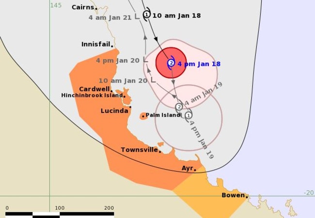
The system was upgraded to a Category 2 Monday afternoon and by 4pm was about 165km southeast of Cairns and 165km north of Townsville, bringing winds up to 140km/h.
The Bureau of Meteorology said there was high uncertainty with the cyclone but it’s likely it could cross the coast.
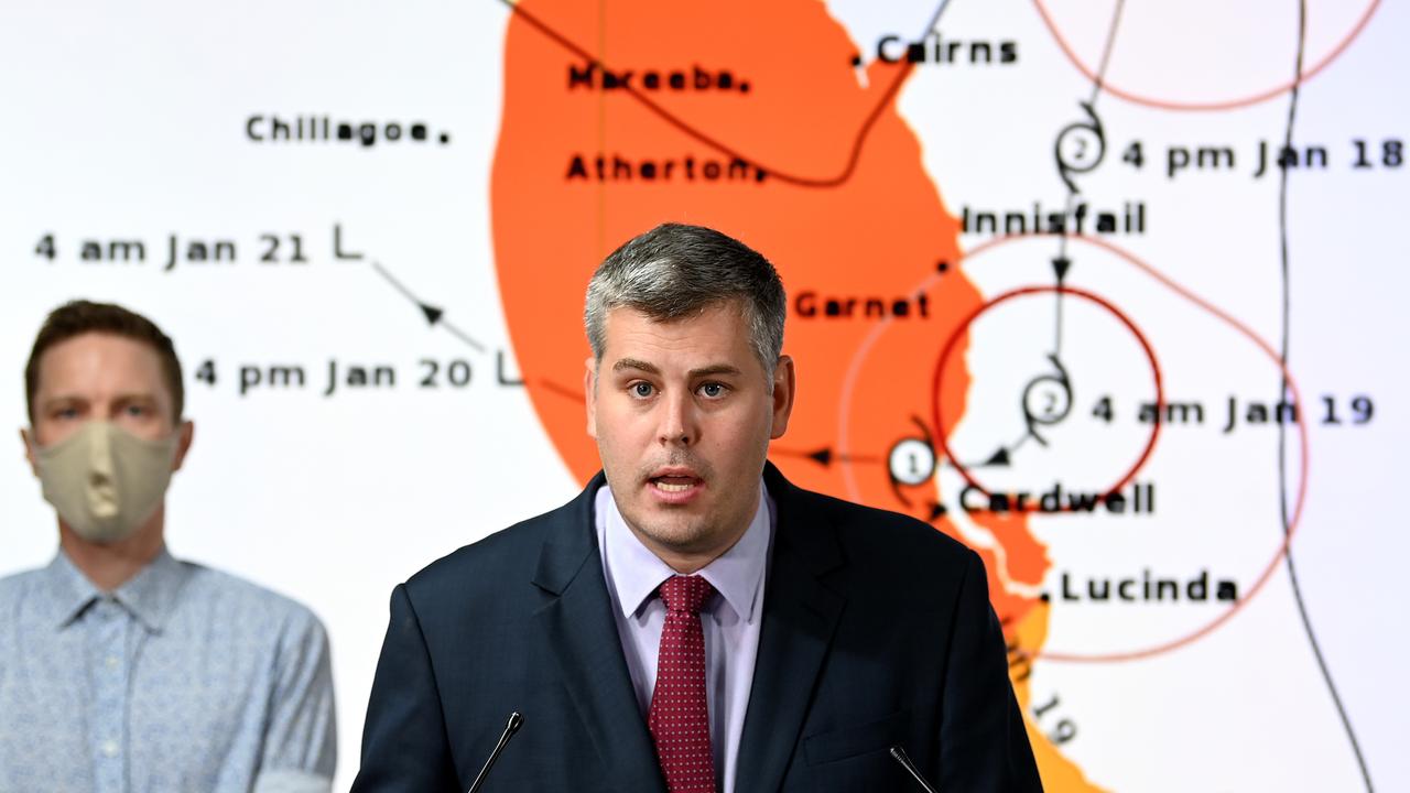
“This particular cyclone is unusually unpredictable,” Emergency Services Minister Mark Ryan said during a press conference at 4pm.
Premier Annastacia Palaszczuk said authorities were satisfied with the preparations and reminded Queenslanders to stay safe.
A flood watch remains for between Cape Flattery and Ingham.
Meanwhile between 50 and 100mm of rain is expected to fall across parts of the southeast as the region is battered by severe thunderstorms.
Earlier, in their 1pm update, the Bureau of Meteorology said the cyclone was expected to slow and stall off the coast between Hinchinbrook Island and Townsville.
“However, considerable uncertainty remains with the future movement of the system, and a Category 2 coastal crossing between Hinchinbrook Island and Townsville tonight or on Tuesday remains possible,” a statement from the bureau said.
At 10am, Cyclone Kimi was located 90 kilometres east of Cairns and 250 kilometres north of Townsville and is moving south at 12 kilometres per hour.
The system was expected to bring hazards including: destructive winds up to 130km/h for coastal and island locations between Innisfail and Lucinda; gales with gusts up to 12km/h for coastal and island communities between Port Douglas and Ayr; heavy rainfall and flash flooding between Cairns and Townsville; and abnormally high tides as the cyclone approaches the coast.
A popular tourist island has been evacuated and urgent flood warnings issued with Kimi expected to drop up to 300mm on already “saturated” areas of the state.
Emergency preparations are under way across the state.
Fitzroy Island, off the coast of Cairns, has been evacuated and will be closed until Wednesday in anticipation of the storm.
“As part of our cyclone procedure, Senior Management have been monitoring the progress of Tropical Cyclone Kimi closely,” a post from Fitzroy Island resort said.
“As guest and staff safety is our number one priority, the decision has been made to evacuate all guests and a majority of staff off Fitzroy Island to Cairns.”
Emergency Services Minister Mark Ryan said there is a watch zone from Lucinda to Ayr, with Swift water rescue crews are on standby in the north.
Bureau of Meteorology forecaster Alex Majchrowski said “destructive wind gusts … strong enough to bring down trees and powerlines” were possible for parts of north Queensland.
The bureau has warned of flash flooding between Cairns and Ayr with the cyclonic weather expected to dump up to 300mm of rain on already “saturated” regions.
Queensland Premier Annastacia Palaszczuk said the state was well prepared with emergency services on full alert and ready to help but urged residents to “take care”.

“North Queenslanders know what to do — listen to emergency warnings and, above all, stay off flooded roads,” Ms Palaszczuk said.
“The bureau is warning of strong winds and very heavy rain.”
Cassowary Coast Division 1 Councillor Barry Barnes said his major concerns were how saturated the ground already was and the height of the rivers.
“We’ve never had them so full before we’ve had a bit of a low. But our main ones are the Tully and Hull (Rivers), and they’re already sitting at about 75, 80 per cent full,” he said.
“The ground is very saturated and my other concern is the banana farms, a bit of wind will knock those trees over.”
Townsville Mayor Jenny Hill urged residents to be on alert and to ensure they have enough food and water to last them three days.
“Council’s ERG group has met and we’ve begun roiling out sand and sandbags into areas we believe might be affected,” Ms Hill said.
“I also wanted to t ask the community to make sure that they’re ready in case this system either increases in strength or ends up closer to making landfall into the Townsville Local Government Area.
“Make sure you’ve got enough food and water to last you three days, make sure you’ve cleared your property of any loose items.

“At the moment because we’re not sure exactly where the tropical cyclone will make landfall or when, we’ve decided to take a cautious approach.”
A minor flood warning is current for the Tully River on the North Tropical Coast, and the bureau has warned that minor to moderate flooding is possible for catchments of the Mulgrave and Russell Rivers, Johnstone River, Tully River, Murray River, Herbert River, Black River, Ross and Bohle Rivers and Haughton River.
“Heavy rainfall has fallen over the majority of catchments within the Flood Watch area over the last two weeks. Rivers will therefore respond relatively quickly to further rainfall,” the Bureau of Meteorology’s flood warning says.
“Minor to moderate flooding is possible in the Flood Watch area, particularly within the catchments where flooding has recently occurred. Isolated major flooding is possible.”
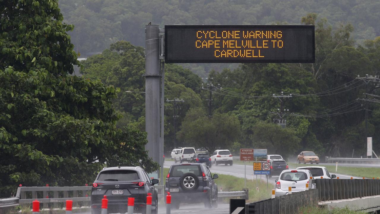
Cairns and Mourilyan ports are currently closed and vessels are unable to leave their moorings with the Port authority issuing a Cyclone Red Alert last night.
More Coverage


Monster weather system brings storm, heavy rain to Qld
Brisbane and surrounding parts of the southeast have been hit by storms and heavy rainfall this afternoon as a 3000km-long monster low moves across the state.

Wild storms, polar blast as 3000km monster low barrels towards Qld
The system, which stretches 3000km from north to south and encompasses 30 per cent of Australia, is forecast to pack a punch when it hits Queensland.