
Insane rainfall totals revealed after two-day deluge as new storm and humidity threats loom
Parts of Queensland have been smashed by hailstorms following the weekend deluge that dumped almost 300mm on the southeast, and the storms are continuing this morning.
QLD weather news
Don't miss out on the headlines from QLD weather news. Followed categories will be added to My News.
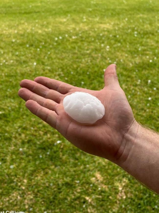
Morning thunderstorms are sweeping across South East Queensland after tennis-ball-sized hailstones were found in a Central Queensland town on Monday afternoon, as an intense weather event lashed the region.
Stones with a diameter about 10cm were reported at Ambrose, while huge hail also fell at Mt Larcom.
Residents took to social media to share their hail pictures, with Neil Jenman of Baralaba saying: “Never seen a storm as savage here.”
Weather bureau meteorologist Kimba Wong said giant hail remained a risk in Central Queensland.

“That’s the largest hail report that I have seen so far today but certainly not overly surprising given the environment today,” she said on Monday evening.
Overnight storms swept over the state’s southeast, delivering heave rain showers, and have continued into the morning.
Ms Wong said the storms would continue as the day progressed, but the chances of large hail were reduced.
⛈ï¸Early morning showers and storms continue to push east across the Darling Downs and #SEQld. Not currently severe, but will make for a wet commute. Take care on the roads and keep an eye on the radar. https://t.co/CocrScN4dUpic.twitter.com/8URP2BmmOz
— Bureau of Meteorology, Queensland (@BOM_Qld) October 24, 2022
“Probably not quite as much of a risk of giant hail,” she said.
“Large hail over two centimetres is certainly possible if we do see some severe storms developing during the afternoon.
“At this stage it looks like less of a dynamic day
Monday’s giant hail came as a “supercell” storm smashed the Fraser Coast, with Howard and Torbanlea in the firing line.
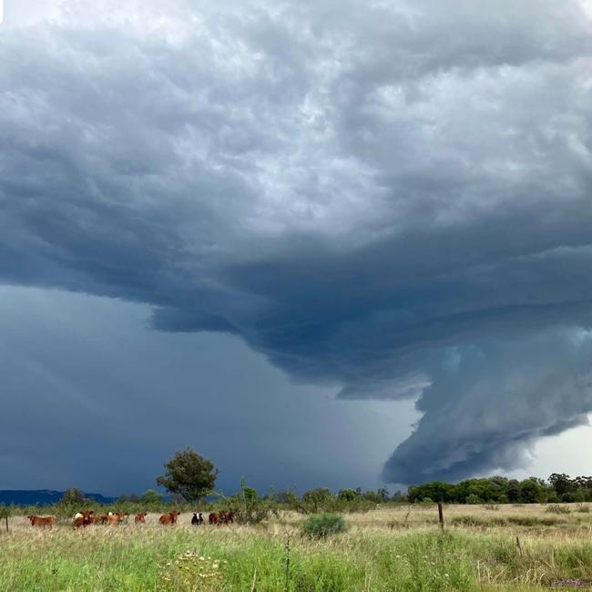
Brisbane enjoyed some blue skies and sunny conditions on Monday, but the threat of severe storms still loomed.
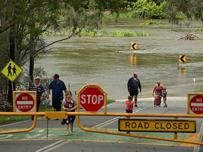
South East Queensland may have dodged a bullet at the weekend in avoiding the worst case forecast for torrential rainfall, but there could be more on the way with the risk of severe thunderstorms on the horizon.
A major flood warning remains in effect for the Macintyre and Barwon Rivers, with the Macintyre expected to peak at 10.2m on Monday, while the Barwon will continue to rise over coming days.


⛈ï¸Today's Storm Forecast 24/10⛈ï¸
— Bureau of Meteorology, Queensland (@BOM_Qld) October 24, 2022
Severe storms w. large hail, damaging winds and heavy rain possible in central, southern & #SEQld today. Very dangerous severe storms w. giant hail possible in the #Capricornia. Warnings will be issued here: https://t.co/2C9mCV30o5pic.twitter.com/etJG0sFw7G
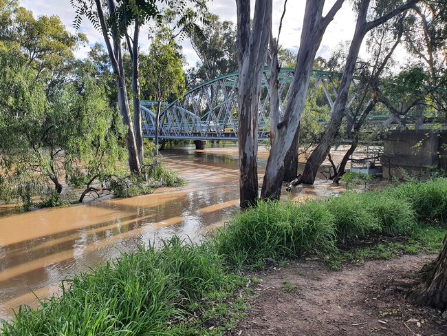
Tin Can Bay recorded the most rain in the past week, notching up 371mm between Monday, October 17, and Sunday, October 23, closely followed by Rainbow Beach with 319mm, and
The Heathwood Alert, just south of Emerald, also recorded huge totals with 228mm in the past week, with Bundaberg close behind with 222mm.
SEE THE 10 HIGHEST RAINFALL LOCATIONS BELOW
But as the risk of heavy torrential rainfall moves south of the border, increasing temperatures and humidity will spur the chance of severe thunderstorms throughout the week.
Each day in the work week has a risk of storms, with Tuesday shaping up as the day to watch.
Danny Teece-Johnson from the Bureau of Meteorology said that while the South East was “out of the woods”, more wet weather is on the way.
“Looking at partly cloudy conditions, showers with possible storms most likely from late morning,” Mr Teece-Johnson said.
“There’s some chances of some afternoon thunderstorms around, possibly severe for Tuesday around the region as we still see the tail of this tropical low move south.
“We are seeing temperatures increasing though, particularly the minimum. We’re up around 17C and 19C across the region.
“Across the region, temperatures are increasing over the next few days, so we will see those minimum temps stay around 16 to 20C, and the maximum reaching that 30 to 34 temperature range.”
Mr Teece-Johnson said the South East was “out of the woods” after the recent weather system moved away, and final food warnings have also been issued.
“There’s still a system coming through early next week but as far as this big system is concerned, it’s certainly moved south,” he added.
“Most of the rainfall, the flooding and the winds in the surf will dissipate over the coming days.”
And while the threat of rain will be limited to thunderstorms across the southeast corner, a heatwave warning has been issued for northern reaches of the state extending from the cape through to the Northern Goldfields and Upper Flinders regions.
Townsville is expected to reach 34C on Wednesday and Thursday, and Cairns will reach 35C on both days.
The southeast, while spared the worst of the hot weather, will still be in for a muggy week.
Recent heavy rainfall will combine with warmer temperatures to stir an increase in humidity to make for uncomfortable conditions.
A Bureau spokesman warned intense humidity will “hit like a tonne of bricks” with our first 30 degree days since April following a “very cool” spring.
On Monday, Brisbane was expected to reach a top temperature of 31C, 29C on Tuesday, and low 30s for the rest of the working week.
Similarly, the Gold and Sunshine Coasts can expect to breach 30C throughout the week, with Friday shaping up as the warmest.
TOP 10 RAINFALL TOTALS (in mm) OCT 17-23
TIN CAN BAY (DEFENCE) 371.2 (288mm on Saturday)
RAINBOW BEACH 319.0 (264mm on Saturday)
HEATHWOOD AL 228.0 (148mm on Wednesday)
BUNDABERG ALERT 222.0 (162mm on Saturday)
LOWER SPRINGBROOK ALERT 221.0 (98mm on Sunday)
BUNDABERG AERO 217.6 (94mm on Sunday)
FRASER ISLAND EURONG 207.0 (147mm on Saturday)
SPRINGBROOK ROAD 203.0 (94mm on Sunday)
LOWANNA (Northern NSW) 201.0 (99mm on Saturday)
SPRINGSURE COMET ST 197.6 (131mm on Wednesday)
CRAIGMORE AL 196.0 (103mm on Wednesday)
TALAGAI 188.4 (74mm on Thursday)
SPRING CREEK STATION 184.0 (97mm on Wednesday)
TEDDINGTON WEIR HW TM 181.2 (109mm on Saturday)
MUSKET FLAT MT ALERT 180.0 (139mm Saturday)
BARRABA (Northern NSW) 174.2 (94mm Friday)
COBBADAH (Northern NSW) 173.0 (88mm Thursday)
WOORARRA 172.0 (108mm on Wednesday)
PACIFIC HEIGHTS 170.6 (65mm on Friday)
WHYENBAH 170.0 (68mm on Friday)

Read related topics:Weather
Join the conversation

Storm shield: How AI will protect our state of disaster
Queensland has secured world-first AI storm detection technology in a $3m partnership between Suncorp and the state government to revolutionise natural disaster response.
Read more

Hail, rain, wind, SNOW: Winter storm on Qld collision course
A rare winter storm threatens to dump 15cm of snow on Queensland's Granite Belt this weekend as forecasters warn of an incoming polar air mass.
Read more