
Higgins Storm Chaser reveals what path Tropical Cyclone Alfred could take
Higgins Storm Chasing has made a bold prediction based on latest modelling on where TC Alfred should make landfall on Queensland and what impact it could have on Brisbane.

QLD weather news
Don't miss out on the headlines from QLD weather news. Followed categories will be added to My News.
Thomas Hinterdorfer has become one of Queensland’s most trusted ‘storm chasers’, with more than a million followers consuming each educated warning, prediction and footage of some of Australia’s most hectic weather events.
While some weather models are in agreement that Tropical Cyclone Alfred is on a collision course with a populated stretch of the Queensland coastline, many factors remain up in the air as to if, where and how strong landfall could be.
We asked Higgins Storm Chasings' front man what storm chasers think will become of Alfred, including whether it will cross the coast, where it could hit and if South East Queensland will feel the effects.
What is the modelling saying?
While a range of possibilities surrounding where Alfred will make landfall – if it indeed moves towards the Queensland coastline – remains, Mr Hinterdorfer said if it went as predicted, the system could make landfall south of Mackay.
“There’s a lot of key components to it at the moment, some upper level ridging and some high pressure ridging that will determine where it wants to go,” he said.
“And it’s all about the timing of when those features interact with the system, and that’s why we’re sort of getting such a massive spread in model data, way beyond the current three, four, five-day stretch.
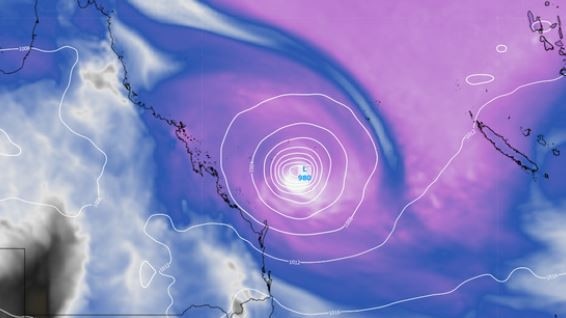
He went on to say at this stages all models seemed to have Alfred track south to or past Mackay, before then taking on a southwest track.
“Of the reliable data, everything is going at least south of Mackay, and then, of course, you know, there are still some models that say it won’t hit land, it’ll come towards the coast and then curl away,” he said.
“Others are still saying that it will hit land, and then there is still a decent range in the strength.
“Over the next three days models know what’s happening, it’s going to move south and it’s going to get to at least about… offshore Mackay, maybe Rockhampton.
“That’s where the model disagreement starts to come in, and then from there, it’s like all over the place.”
Agreeable modelling will likely not form until about the weekend, Mr Hinterdorfer said, with some suggesting Alfred could head for the coastline at the beginning of next week, others say much later in the week.
What happens if it does make landfall?
Mr Hinterdorfer said if Alfred were to make landfall as a tropical cyclone, it would likely be torrential rainfall that would create the most headaches for Queenslanders.
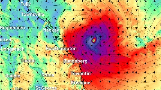
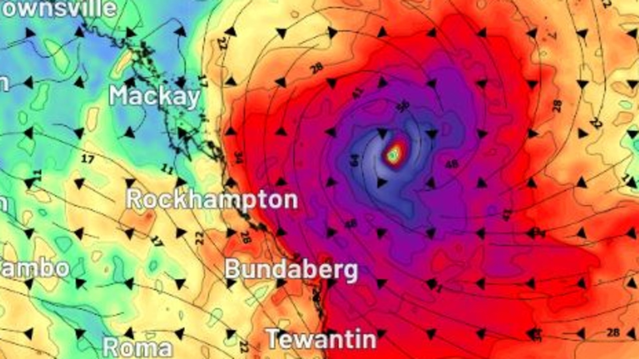
The strongest tropical cyclone to make landfall above Central Queensland was TC Marcia in 2015 as a category five system, however many storm chasers say this is an exception, with most tropical cyclones in history that have crossed south of Rockhampton generally presented as category one to three systems.
“So if a landfall was to happen and heavy rain was on the cards, 100 to 200 millimetres is not dramatic, like most areas would handle that comfortably right now because everything is just so dry, so it would be more if you’re getting up past that half a metre of rain, kind of 500mm plus, that we would start to see flood issues,” he said.
“But again, that’s a question that we will have an answer to, hopefully, in the next few days.”
While areas of the south east, including Brisbane, Gold Coast and the Sunshine Coast, would likely feel the effects from a Central Queensland landfall, the intensity of the system would not likely reach a category four or five.
“Of course, you know, things can change, and those records can be broken and everything like that. But history would just tell you that cat one or two is the most likely if it were to be a cyclone at landfall.”
What does this mean for Brisbane?
Storm chasers have not ruled out the possibility of SEQ feeling the effects of Alfred and would depend on how far south it made landfall.
“There’s plenty of instances where systems have come down from Central Queensland, so a Central Queensland landfall wouldn’t rule out south east Queensland by any stretch,” Mr Hinterdorfer said.
“If it were to make landfall north of Brisbane, then there’d definitely be some impacts in SEQ, the most obvious, as I said, heavy rain, and then obviously, the closer it gets to SEQ, the more obvious those effects are.”
Could the system cross as an ex-cyclone?
Another possibility on the cards is TC Alfred could cross the Queensland coast as an ex-tropical cyclone, however this may not mitigate the risk of torrential rainfall.
Mr Hinterdorfer said a similar scenario to ex-tropical cyclone Seth could occur with Alfred, which produced 600mm in 24 hours near Gympie and other areas of the Wide Bay and South East, but was a tropical low by the time it impacted the coast.
“It (Seth) didn’t really have wind attached to it … because it was an ex-cyclone, but it’s focus shifted to heavy rainfall.”
He went on to say in this situation, the severity of the system would depend on how long it stuck around.
What needs to happen for Cyclone Alfred to cross the QLD coast?
Mr Hinterdorfer said there were two factors that would need to go right for Cyclone Alfred to begin tracking for a Queensland landfall.
“A lot would need to go right, and a lot current data is going right,” he said.
“It would need, I think, the ridge over New Zealand, to strengthen and potentially shift a bit more north, or bulge north over New Zealand … and then give some sort of like north east, south west slant on our side of that ridge.
“And then, of course, you need to couple that with a weakening of the high across the Tasman as well.”
Mr Hinterdorfer said the high had already weakened a fair bit, but would need the high pressure ridge to weaken further in order to create a “channel” for Alfred to come through.
Cyclone Alfred predicted to impact highly populated Qld areas
Most weather models are in agreement that Tropical Cyclone Alfred is on a collision course with a highly populated stretch of the Queensland coast. EVERYTHING WE KNOW

Shoppers flipping out over Kmart’s shock new gold-coin charge
Kmart shoppers have been caught out as the retail giant rolls out coin operated trolleys, but we have a hack to help you avoid the charge. HAVE YOUR SAY