
Extreme heatwave set to smash Queensland after wild storms
Much of Queensland is set to be hit by unprecedented heat, high fire danger and potentially destructive thunderstorms in an extreme weather event set to smash into the state from today.
QLD weather news
Don't miss out on the headlines from QLD weather news. Followed categories will be added to My News.
Queensland is set to swelter with a heatwave bringing soaring temperatures in the southeast as fire warnings are issued across central and southern Queensland.
BOM meteorologist James Thompson revealed the dire forecast should start being felt as early as Thursday morning, resulting in most of the state experiencing hot and muggy conditions.
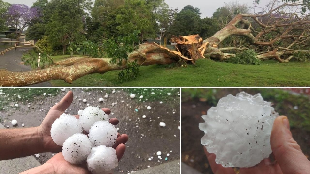
Super cell fury: Three trapped in roof collapse, nine storm cells, 13cm giant hail, roof collapse
Damage bill from super cell storm to top $1 billion
Brisbane and Toowoomba will hit 31C, Ipswich and Gatton are forecast to hit 37C.
The Gold Coast will reach 30C today with possible storms while the Sunshine Coast will hit 32C also with potential for storms.

In the north, Rockhampton is expecting maximums of 37C, Longreach will reach 41C and Mount Isa will peak at a sizzling 42C.
“Those conditions really are heating up … with unseasonably hot temperatures across Queensland,” he said.
“This will result in Thursday’s maximums expected to be 5-8 degrees above average.”
The bureau issued fire weather warnings for the Maranoa, Warrego, Central Highlands, Coalfields and Darling Downs regions with dusty conditions also expected
“We’re set to see raised dust with hot dry and dusty conditions through those regions as well,” Mr Thompson said.
“While the south-westerly winds topping at about 45km/h won’t make their way as far south as the Sunshine Coast, the southeast will experience some greater gusts, sitting around the 20-25km/h range.”
BOM is also expecting “gusty thunderstorms” for parts of the southeast and the broader state over the next week.
These wet and windy conditions will lead into stronger isolated showers for the central and eastern regions for the weekend, with Saturday set to deliver possible thunderstorms.
“We could even see isolated totals from these weekend events topping over 50mm in some regions.”
Tristan Holman-Lee, 8 and his parents have moved from Newcastle to Redcliffe, experiencing the full brunt of Queensland weather.
“We were going kayaking with dad and mum and mum wasn’t feeling safe so she went to shore and then we went back,” Tristan said.
He said he’s going to get back on the water to escape the heat today.
“I’m going to go kayaking all over Scarborough,’ he said.