
Super cell fury: Three trapped in roof collapse, nine storm cells, 13cm giant hail, roof collapse
Yesterday’s wild weather was the worst hail storm seen since 2014, according to RACQ. Nine severe fronts caused chaos as 14cm hail fell and more than 50,000 homes and businesses lost power. There were 15,000 still without power on Sunday. SEE PICS, VIDEO, WORST-HIT AREAS
QLD News
Don't miss out on the headlines from QLD News. Followed categories will be added to My News.
Yesterday’s wild weather was the worst hail storm seen since 2014, according to RACQ.
Three people were trapped inside their home after a roof collapse, giant hail up to 14cm smashed southeast Queensland and more than 50,000 properties lost power as a violent supercell of nine “life-threatening” severe storm fronts unleashed its fury into Saturday evening.
RACQ spokesperson Lucinda Ross said it had been a scary evening for many residents.
“This is the worst hail damage we’ve seen since Brisbane was hit by a severe hailstorm in 2014. We’ve already had 1380 claims come in for damage – more than 900 for vehicle damage overnight, and 480 for home damage,” Ms Ross said.

“The worst of the damage, according to our claims, is in Springfield, Rosewood, Greenbank and Boronia Heights.
“It’s been a terrifying experience for many people and we’re working hard to make sure we can help our members process their claims as soon as possible and fix any damage.
“We do ask for our members’ patience as we work through managing these claims. If you need to make a claim with RACQ, the best thing to do is to go online and start the process. We will then assign your claim to one of our team who will give you a call back as soon as possible.”
There were still 15,000 Energex customers without power on Sunday – almost 4500 in Ipswich, almost 4000 in the Noosa region, another 4000 in the remainder of the Sunshine Coast and almost 3000 in Redland City region.
An Energex spokesman said crews were dealing with significant damage and the expectation was that the majority of homes across the southeast would have power restored by early Sunday night.

However, it was likely some homes on the southside of Brisbane will not have power restored until significant damage is repaired by an electrician.
About 131 power lines fell as a result of yesterday’s storms, 121 of which were on the Sunshine Coast.
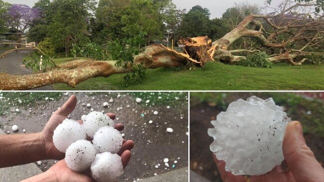
Huge 14cm hail was reported at Forestdale, 13cm at Hillcrest, 9.5cm hail at Boronia Heights, 8cm hail at Springfield, 7.2cm hail at Amberley and 4-7cm hail at Gatton and Adare as the supercell tracked east from about noon Saturday.
RACQ Insurance reported Saturday night it had received 445 motor claims and 245 property claims from the storm.
Three people, including two children, were forced to free themselves from their Ipswich home after their roof collapsed.
Emergency Services, including Police, Paramedics and Fire & Emergency Services arrived on scene at Wanderer Crescent, Springfield Lakes just after 4pm Saturday.
It’s reported a tree fell on the house, causing a partial roof collapse.
The three occupants were initially trapped inside, but were able to free themselves. An ambulance spokesman confirmed the three occupants had not sustained any injuries
At one point, the wild storm was so furious motorists were forced to stop in the middle of the M1 at Logan and shelter in underpasses until the hailstorm eased.

To the west, Queensland police and QFES declared an emergency alert for the Lockyer Valley, Ipswich, Laidley, Jimboomba and Amberley residents, where severe thunderstorms were forecast to bring destructive winds and giant hail.
⚡🚨⚠ï¸âš¡ LIFE THREATENING STORMS IN #SEQLD, including #GoldCoast #Logan #Brisbane #Ipswich councils with 13cm HAIL reported at Hillcrest. Stay safe #Queensland. Listen to @QldFES advice and ABC radio for the latest as well as our warnings at https://t.co/r4IpFfEevt. pic.twitter.com/xkJClp6IoP
— Bureau of Meteorology, Queensland (@BOM_Qld) October 31, 2020
More than 50,000 properties were without power in the height of the storm as the supercells ravaged the southeast.
These included more than 1000 in Brisbane, nearly 12,000 on the Gold Coast, more than 16,000 in Logan, 2,007 on the Sunshine Coast and 1,577 in Ipswich city.
A large tree was also downed and blocking Stradbroke Avenue at Tamborine.
“Like a cyclone hit our street,” a local wrote on Facebook.
“Big tree down on Stradbroke Ave. Powerlines down along the street. Energex notified.
“Stay clear, especially the kids for Halloween. Very dangerous.”

Severe thunderstorms continuing over #SEQ. Damaging to locally destructive winds and large, possibly giant hail remain possible. Latest updates: https://t.co/hzlqmnMe6u pic.twitter.com/KfXwu9jXM7
— Bureau of Meteorology, Queensland (@BOM_Qld) October 31, 2020
The BOM warned, at 6pm Saturday , that widespread dangerous thunderstorm activity continued throughout southeast Queensland despite a supercell situation in some areas easing.
It warned ‘volatile and dangerous’ storms were likely to keep firing up into the evening.

At Springfield and Rosewood there were reports of hail damage to cars.
After wreaking havoc on the Darling Downs, Gold Coast, Logan, Ipswich and Brisbane, the Sunshine Coast was in the firing line from about 5pm.

Forecasts show the storms have left for now, with none predicted at this stage for the remainder of the week. Sunday’s forecast is for sunny conditions and a top of 33.
EARLIER
Queensland Fire and Emergency Services reportedly received around 1,000 storm related requests for assistance in the afternoon while the SES has received more than 1450 requests for assistance with numbers still climbing rapidly.
RACQ had already received 170 claims for property damage and 340 for cars.
Meanwhile, a tree has come crashing down onto a car outside a major Gold Coast polling booth.
A photo posted to social media shows the large tree on top of the vehicle outside the Palm Beach-Currumbin State High polling booth.
Followers of the Palm Beach Locals Facebook page expressed shock and said they hoped no-one was hurt.
“I couldn’t see anyone in the car when we drove past,” Jemma West wrote.
One of the page’s followers, Rebecca Selby, posted: “Drove past no-one in the car. Apart from smashed windscreen and damage to bonnet it appears to be very little other damage.”
The damage to cars in Springfield Lakes. Every single car not in cover totalled #bnestorm #bneweather pic.twitter.com/JFpU39aXKG
— Tom Armitt (@tom8375) October 31, 2020

RACQ spokeswoman Lucinda Ross told The Courier-Mail plenty of damage has already occurred from the wild weather.
“We’ve been inundated with calls from members with damage and expect claim numbers to rise as this weather system moves across the region,” she said.
“According to our data, the worst impacted suburbs so far are Rosewood and Springfield.
“The quickest way to start your claim with us is to lodge it online and our team will get back in touch as soon as possible.”

Meanwhile, a large hailstorm struck northern Gold Coast suburbs as the dangerous storm cell swept across the city.
Golf-ball-sized hail was reported in suburbs including Pacific Pines, Helensvale and Coomera.
The storm caused disruption as state election polling booths, with candidates and their supporters forced to take cover.
It came after Weatherzone metrologist Craig McIntosh said a storm cell which reached the Gold Coast at about 12.30pm had the potential to bring with it giant hail and destructive winds throughout the afternoon.
And a tree caught fire when struck by lightning at Wivenhoe.

Queensland Fire and Emergency Services has issued an emergency alert amid deteriorating wild weather across southeast Queensland.
Earlier Saturday afternoon, voters were being urged to cast their ballots early as the Bureau of Meteorology warned wild and unpredictable conditions were threatening to bring chaos to the southeast.
It’s the latest alert after a week of destructive storms across Queensland that has flooded roads and cut power to thousands of homes.
Round 2 brisvagas storms. #bnestorm #surburbia #wff pic.twitter.com/r8BXuY5qln
— Julie (@Jp88Julie) October 31, 2020
Spring hail storm #itsrainingtennisballs #bnestorm #bneweather #QldWeather #springfieldlakes #hailstorm pic.twitter.com/Wvok9eJCb3
— Shanon Hovi (@ShanonHovi) October 31, 2020


Jimboomba #bnestorm pic.twitter.com/mUQE3FQlJp
— Politic@l Spinner.. (@LesStonehouse) October 31, 2020

Earlier Saturday , the Bureau of Meteorology issued two warnings for rapidly developing storms likely to produce damaging wind, heavy rain and large hail.
Severe thunderstorms were detected on the weather radar near the area between Boonah and Beaudesert, Hampton, Mount Barney and Murphys Creek.
Damaging winds, large hailstones and heavy rainfall that may lead to flash flooding were predicted.
The bureau’s other warning for severe thunderstorms, damaging winds, large hailstones and heavy rainfall pertained to the Gold Coast, Brisbane, Gympie, Kingaroy, Caboolture, Coolangatta and Ipswich.
Currently at Goodna pic.twitter.com/hbAkAGosGQ
— SEQUEST (@SEQUESTRADIO) October 31, 2020
A polling day downpour with giant hail, heavy rain and destructive winds was predicted to hit the southeast between 2-3pm.
BOM and Higgins Storm Chasers predict ‘dangerous storms’ for polling day
Bureau Meteorologist James Thompson said the storm would start building in the west around late morning.
“We have reasonably clear weather in southeast Queensland this morning, so if you are going to go out today, or be on the road, best chance of clear weather is now,” Mr Thompson said.
“They’re likely to develop through the eastern Darling Downs and move across from there. There is the risk of giant hail, destructive winds and heavy rainfall that may lead to flash flooding with the thunderstorms this afternoon.”
Storms will be developing from the late morning with Brisbane forecast for 31C and between 10-30mm of rain today.
There is also a very high fire danger warning, due to some ‘unseasonably warm’ conditions in the Central Highlands, Coalfields, parts of the Darling Downs, the far north in the Peninsula, Northern Goldfields and upper Flinders districts.
It comes after two days of severe storms hit the southeast on Tuesday and Wednesday this week.
There was flash flooding on Tuesday in Kedron and Woolloongabba and nearly 100,000 lightning strikes on Wednesday.


