
Cyclone Trevor makes landfall south of Lockhart River as Category 3 storm
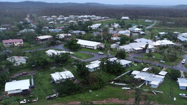
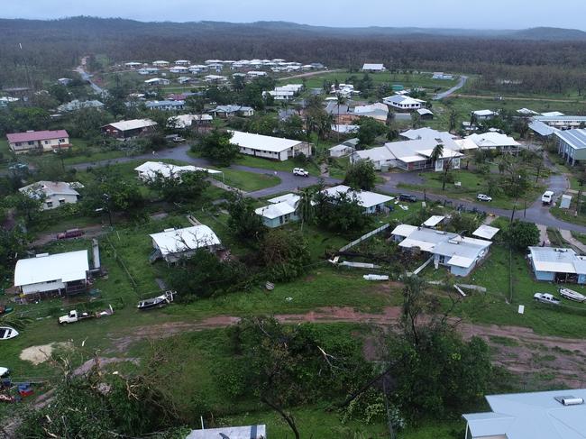
Two remote far north Queensland communities could be without electricity for days, as drone footage reveals the extent of Cyclone Trevor’s devastation. SEE THE VIDEO

QLD weather news
Don't miss out on the headlines from QLD weather news. Followed categories will be added to My News.
TWO remote far north Queensland communities could be without electricity for days after Cyclone Trevor tore down trees and power lines.
The entire communities of Lockhart River and Coen were without power this morning, as residents began to emerge from their homes to assess the damage.
Large vehicles unable to cross the Daintree Ferry due to predicted flooding
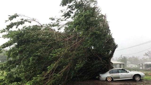
The category-three storm ripped through the region late yesterday, dumping over 200mm of rain in just six hours and bringing wind gusts of over 130km/h.
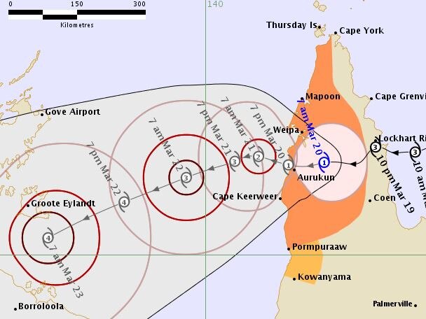
It has since weakened to a category-one system, and is expected to pass just north of Aurukun on the west coast of Cape York before reintensifying into a category-four storm as it pushes towards the Northern Territory.
An Ergon Energy spokeswoman said 460 properties — including 180 in Aurukun — had lost power because of the cyclone.
Energy crews were ready to be deployed as soon as airstrips in the remote communities were safe for landing, but it could bedays before power was fully restored.
The manager of Lockhart River’s small airport will have to talk aircraft on to the tarmac after crucial equipment was knocked out.
Lockhart River Mayor Wayne Butcher said Trevor was the worst cyclone he had endured.
“It was ferocious — the wind was just constant between 4pm and midnight,” he said.
“This was probably the worst one... this one basically sat near the community and hounded us for hours.
“I’ve got a timber house and I could feel it shaking.”
Lockhart River resident Hannah Brown posted on Facebook she had spent the evening “getting absolutely smashed”.
“We’re OK at the Lockhart River aerodrome; lots of destruction after a horrid night,” she wrote.
Cr Butcher said initial reports suggested no major infrastructure damage.
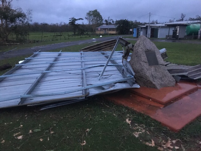
“We’ve got a few trees across houses and a few sheds have gone flying,” he said.
The cyclone warning for the east coast has since been cancelled, but the danger is not entirely over, with a fresh risk of flooding.
“We’re going to see large falls right up to next Friday, with chances of flash flooding,” the Bureau of Meteorology’s Jess Gardner said.
“It will be very dangerous.”
A moderate flood warning remained in place for the Daintree River, with a general flood warning for the Mossman River.
Roads and schools remain closed across the Cape, and residents are reminded not to risk driving on flooded roads.
Chief Superintendent Brian Huxley said police had flown a drone over the Lockhart River township this morning and it was littered with corrogated iron from shed roofs, fallen trees and downed powerlines, but there had been no reports of injuries.
“The issue is how we get people in to assist,” he said.
“Ergon and Telstra are primed and ready to go.
“But there is low cloud over the hills and wind from the east ... so pilots don’t like doing it without good advice.
Flooding over the Mulligan Highway this morning at the McLeod River cross.
“The technical equipment used to determine cloud level has been damaged so the airport manager will have to give visual help.”
Chief Supt Huxley said the weather bureau expected conditions to improve by about midday, which could give them a window of opportunity to bring in help.

EARLIER:
CYCLONE Trevor tore off roofs, flattened sheds and downed powerlines and trees with sustained 150km/h winds in a 12-hour onslaught at the indigenous township of Lockhart River on Cape York last night.
Police report no injuries but at first light started door-to-door checks of 800 residents in the former aboriginal mission, 760km north of Cairns.
Communities were in lockdown on Tuesday and roads and schools closed as the category three tropical storm made landfall just south of Lockhart River, dumping more than 300mm of rain and delivering winds up to 130km/h.
“Most of the main structures escaped major damage, but a number of sheds are destroyed, lots of trees are down, and there is no power,’’ disaster co-ordinator Chief Superintendent Brian Huxley told The Courier-Mail.
“One family of 10 got a fright when a tree branch smashed through a window at a refuge centre.
“There were a lot of tree branches and iron sheeting flying around in the high winds.
“We are still out doing damage assessments but luckily it appears no-one was hurt or injured.’’
He said the category-three system, packing 220km/h winds at the very destructive core, battered the tiny community.
“It seemed like it just sat on the coast like a spinning top, not moving, when the eye first made landfall south of Lockhart.
“Lockhart just kept getting the wind.
“We’re now expecting some heavy rain.”
Trevor has now weakened to a category-one system as it continues to track west towards the Cape’s western coast.
Cape Grenville to Coen and Pormpuraaw to Cape York are still within the watch zone, after Lockhart River was battered by 300mm of rain since 9am yesterday.
Bureau of Meteorology forecaster Jess Gardner said areas south of that received rain within 50 to 100mm yesterday.
Warnings are in place for Orford Ness to Cape Flattery, extending across the Cape York Peninsula to Pormpuraaw and Mapoon, including Weipa and Coen. Additional emergency crews, including specialist swift water rescue firefighters, have already been deployed to the region.
Tracking maps show Cyclone Trevor jinked north towards Lockhart before heading west where it is predicted to hit Aurukun as a category-one system about 7pm tonight.
It is forecast to rapidly intensifying into a category-four in the Gulf of Carpentaria as it moves towards the Northern Territory.
Disaster crews are on standby ready to deploy to Lockhart River to help with the post-cyclone recovery once the airport is cleared and open to air traffic.


PM in flood-ravaged north, as military might unleashed on clean-up
Defence Force members are in north Queensland to rebuild parts of the Bruce Hwy as the Prime Minister visits some of the disaster zones, while “disgusting” acts are being reported in evacuation zones.
PM leaves parliament to visit flood-ravaged north Qld towns
The defence force has been brought into rebuild parts of the decimated Bruce Hwy as the Prime Minister has jetted into the north Queensland flood disaster zone.