
Cyclone Kimi expected to cause major flooding in north Qld
Ex-Tropical Cyclone Kimi has weakened to a tropical low without making landfall in North Queensland, but intense weather is still expected to hit.
QLD weather news
Don't miss out on the headlines from QLD weather news. Followed categories will be added to My News.
Ex-Tropical Cyclone Kimi has weakened to a tropical low without making landfall in North Queensland, but there remains the chance intense weather could still affect the region.
Staying true to its unpredictable nature, the cyclone, which had developed into a category 2 system during Monday and was heading for the coast near Lucinda turned southeast before weakening to a tropical low 135km northeast of Townsville about 4am.
It’s now expected to move northwest and remain offshore, hugging the coastline to Cairns and Port Douglas beyond.
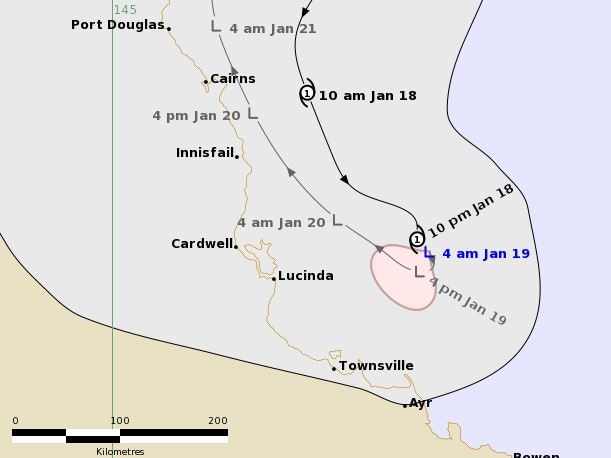
A cyclone warning or Innisfail to Ayr has been cancelled, however significant impacts on the coast are becoming less likely, but intensive weather is still expected to hit.
Residents in areas between Innisfail and Ayr, including Lucinda, Palm Island and Townsville, have been warned to prepare property to be lashed by the storm.
Sustained winds near the centre of the cyclone were recorded at 75 kilometres per hour with wind gusts to 100 kilometres per hour.
The Bureau of Meteorology advises “significant impacts are no longer expected although heavy rainfall remains possible”.
“We do still have the possibility of some heavy rainfall, particularly between Innisfail and Proserpine, at this stage we’re generally expecting between 20-50mm in that region but we could see a severe storm develop which could lead to isolated higher totals,” Meteorologist Rosa Hoff said.
“We continue to have a flood watch current about coastal catchments between Cairns and Ayr because we’ve had so much rainfall in the last two weeks the catchments will likely respond quickly to any heavy rainfall.”
Specialist rescue crews had last night been deployed around north Queensland amid fears recent rainfall will worsen the flood risk of the “unusually unpredictable”cyclone.
The bureau also issued a flood watch for catchments between Innisfail to Bowen for yesterday and today, with authorities fearing recent rainfall would worsen the flood risk associated with the cyclone.
On Monday afternoon Fire and Emergency Services Minister Mark Ryan said the “unusually unpredictable” cyclone was changing tack “every three hours or so”.
Mr Ryan said that because many affected catchments were already saturated, the risk of riverine flooding and localised flash flooding from the cyclone was increased.
Specialised swiftwater rescue crews have been deployed across north Queensland with affected councils offering sandbags to residents.
Premier Annastacia Palaszczuk said SES, police and two winch helicopters were also on standby.
The Bureau of Meteorology was last night expecting Kimi to remain offshore “meandering in the ocean” near Townsville before weakening and moving north up the coast as a tropical low.
However forecaster Laura Boekel said that because there was so much uncertainty, it remained possible Kimi could cross the coast as a category 2 cyclone.
The bureau yesterday warned the cyclone would bring destructive winds up to 150km/h, gales with gusts up to 120km/h, heavy rainfall of up to 300mm, flash flooding and abnormally high tides.
Cassowary Coast Division 1 councillor Barry Barnes said his greatest concern was flooding of the region’s rivers.
“We’ve never had them so full before we’ve had a bit of a low. But our main ones are the Tully and Hull (Rivers), and they’re already sitting at about 75, 80 per cent full,” he said.
“The ground is very saturated and my other concern is the banana farms, a bit of wind will knock those trees over.”
Panic-buyers had stripped shopping centres, including Hermit Park Woolworths where toilet paper shelves were stripped bare.
Further north in Ingham, frantic customers had bought almost every loaf of bread from Woolworths, while in Cardwell the local IGA was swamped by last-minute preppers stocking up on canned food, tissues and long life items.
Queensland Rail closed its Kuranda Range line yesterday, while a number of flights out of Cairns airport were cancelled or rescheduled as a precaution to the cyclone. Townsville Airport was closed from 10pm.

Monster weather system brings storm, heavy rain to Qld
Brisbane and surrounding parts of the southeast have been hit by storms and heavy rainfall this afternoon as a 3000km-long monster low moves across the state.

Wild storms, polar blast as 3000km monster low barrels towards Qld
The system, which stretches 3000km from north to south and encompasses 30 per cent of Australia, is forecast to pack a punch when it hits Queensland.