
Cold snap to kick into gear across South East Queensland
Bitter southerly winds are set to sweep across parts of Queensland, forcing temperatures to feel much colder than they are, multiple weather outlets have warned.

QLD weather news
Don't miss out on the headlines from QLD weather news. Followed categories will be added to My News.
Temperatures across Queensland are tipped to plummet as a prolonged cold snap hits southeastern Australia from this weekend.
Bitter southerly winds could sweep across to the southeast, forcing temperatures to feel much colder than they are from as early as late Saturday and well into Sunday.
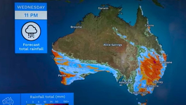
Bureau of Meteorology’s Daniel Hayes said a rain band frontal system would sweep through South and Western Australia and is expected to make its way eastwards to Queensland.
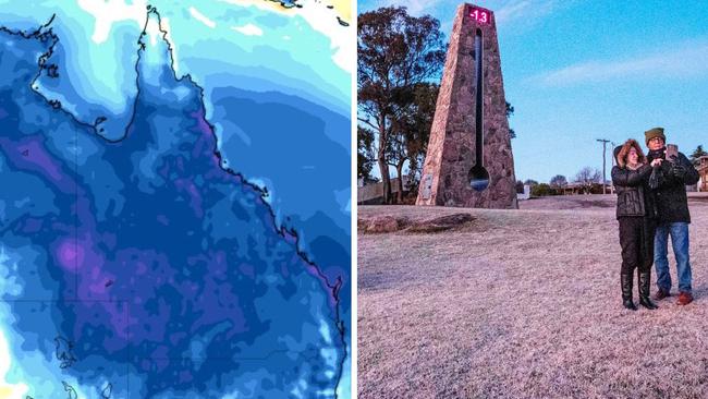
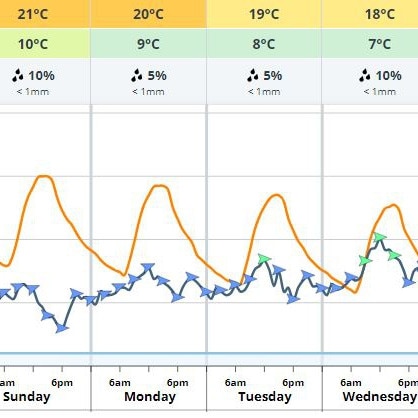
From Sunday, minimum temperatures in Stanthorpe are set to plunge to -1C with 15C maximums until at least Tuesday. Similar conditions are expected for Applethorpe with 0C, Warwick and Oakey 1C.
The combination of a high pressure system with the frontal system would cause cool air from the Antarctic to flow through the southern eastern parts of Australia into Queensland.
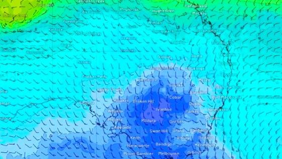
“We may have one or two lows or one large low in the Tasman Sea. The combination of the low in the Tasman and the high in the Bight is going to push some quite strong southerly flow up over the eastern parts of Australia, and that will bring up quite cold air from the Antarctic area,” the senior meteorologist said.
“We’ll see some quite cool air pushing through. (There is also) reasonable potential for snow over the Southern Alps areas, and we’ll see cold air extending in through Queensland from Sunday and into the early part of next week.
“At this stage, temperatures over the next few days will probably be sitting around minimum temperatures … around about average, within one or two degrees.
“Once that cool change comes through, on Sunday, we’ll see those temperatures drop probably at least one or two degrees below average.”
Mr Hayes said cold temperatures could persist for several days well into the middle of next week if the high-pressure system follows in the front’s path and remains over southern Australia.
Temperatures are set to feel far colder than the actual temperatures, according to Weatherzone.
“The frigid air will be dragged from Antarctica by a cold front sweeping across the continent this weekend,” a Weatherzone report said.
“A high-pressure system will quickly follow in the fronts path and remain over southern Australia until at least mid-next week, prolonging this cold outbreak.”
It comes as thick fog blanketed Brisbane on Wednesday morning, causing delays and diversions out of Brisbane Airport.


Cyclone watch: Monster low threatens to form, track south
Queensland’s first cyclone of the season could form off the far north at the weekend, while a separate severe weather system has hammered parts of the region with heavy rain overnight.
‘Intense microburst’: Ferocious storm unleashes havoc across Brisbane
Brisbane felt the wrath of an intense storm last night with heavy rain, 35km/h wind gusts reported across the city with thousands of residents in SEQ losing power after a 35C heatwave.