
Cold snap continues but warmer weather on the way
Subzero starts to the day continue in parts of southeast Queensland but warmer weather is on the way, along with showers.
QLD weather news
Don't miss out on the headlines from QLD weather news. Followed categories will be added to My News.
Subzero starts to the day continue in parts of southeast Queensland but warmer weather is on the way, along with showers.
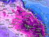
The southeastern corner of Queensland felt the chill the most overnight and into Tuesday morning, with multiple towns hitting negative temperatures once again.
Oakey in the Darling Downs was -2.4C, Amberley in Ipswich got to -1.5C at 6am, along with Applethorpe which hit -3C.
While the Darling Downs and Granite Belt were still experiencing sub-zero temperatures, Bureau of Meteorology meteorologist Shane Kennedy said other areas were warmer than recent days.
“It was a little bit warmer through northern Queensland, still a touch below average in a few places, a bit warmer than it has been in the last few days,” he said.
He said Tuesday’s weather was a mix of minimum temperatures below average and maximum temperatures slightly above average in western and southern Queensland, and that warmer mornings were on the way.
“Overnight temperatures have been a bit below average, 2 to 6 degrees below average for much of the state, but expect that it will start warming up,” he said.
The cold snap was set to break from Thursday, bringing a brief reprieve to Queenslanders and showers to the region.
“The temperature from Thursday will be above average for most of the state in the afternoon and overnight, and it’s due to the wind direction - changing winds swinging around to the east and will be northeast from Thursday, bringing in warmer air from the coral sea and moisture,” he said.
“Isolated falls inland as far as Roma and Emerald can be expected,” he said.
Isolated showers were forecast for the east coast, along with morning frost likely inland in southern and central Queensland, including inland parts of the southeast from Wednesday.
“Mainly over the tropical coast and should expand over the majority of the east coast, pretty light and hit and miss for the next few day,” he said.
Mr Kennedy said the maximum and minimum temperatures were expected to be above average in western Queensland for Friday.
Other parts of regional Queensland, including Longreach and Mt Isa, may see highs reach the 30C mark by Friday, which are well above average.
Brisbane will see temperatures increase to 23C by Wednesday and 25C on Friday and the weekend.
“More significant rainfall will move into southwest Queensland on Friday and move east to southern and central Queensland on the weekend, bringing cloud and rainfall to a broad area like Birdsville area to Darling Downs.”

Monster weather system brings storm, heavy rain to Qld
Brisbane and surrounding parts of the southeast have been hit by storms and heavy rainfall this afternoon as a 3000km-long monster low moves across the state.

Wild storms, polar blast as 3000km monster low barrels towards Qld
The system, which stretches 3000km from north to south and encompasses 30 per cent of Australia, is forecast to pack a punch when it hits Queensland.