
Bureau of Meteorology cancels severe storm warning
THE Bureau of Meteorology has cancelled a thunderstorm warning after storms swept through the southeast. The storm system came through after heavy falls hit the Sunshine Coast.
QLD weather news
Don't miss out on the headlines from QLD weather news. Followed categories will be added to My News.
THE Bureau of Meteorology has cancelled a thunderstorm warning after storms swept through the area.
The BoM said the “immediate” threat had passed but it would continue to monitor conditions.
More than 3200 homes on the Sunshine Coast were without power at 8.30pm due to the severe weather, mostly at Bli Bli and around the Glass House Mountains area. Crews were scrambling to restore power to homes and by 8.45pm that number was down to 1500.
The BoM said at about 8.45pm that the storms were clearing offshore but to expect more over coming days.
The thunderstorm near the #SunshineCoast is now clearing offshore. Severe Thunderstorm Warnings have now been cancelled. However, expect more thunderstorms around #SEQld over the next couple of days, some severe. More info at https://t.co/t5dMGlXTAT pic.twitter.com/ApMdOZn7Sc
— Bureau of Meteorology, Queensland (@BOM_Qld) October 8, 2018
The cancellation was of a thunderstorm warning for an area of the state’s southeast stretching from Fraser Island to the NSW border.
The warning had been issued at 7:35pm after severe thunderstorms were detected on the weather radar near Beerburrum, moving northeast.
BOM had earlier reported that the weather system that was then heading towards Brisbane was likely to “split” apart, with the northern cell moving to the northeast towards Dayboro and the southern cell moving to the southeast. This did not eventuate.
A more general storm warning for the southeast coast and parts of the Wide Bay and Burnett and Darling Downs and Granite Belt districts has also been cancelled.
Shorncliffe, Caboolture, Airport, Redcliffe Peninsula & Sunshine Coast line trains are delayed up to 10 minutes in both directions due to wet weather https://t.co/V3YpveioY7 #TLAlert #TLShorncliffeline #TLCaboltureline #TLAirportline #TLRedcliffepeninsulaline #TLSunshinecoastline pic.twitter.com/uhjypHoj1H
— TransLink (@TransLinkSEQ) October 8, 2018
Earlier, Sunshine Coast hinterland homes were battered by hail this afternoon as a “very dangerous” thunderstorm rolled through the region.
Residents of Cooroy and Eerwah Vale copped a blast of hail while heavy downpours were reported in Cooroibah and Boreen Point, the Sunshine Coast Daily reports.

Between 2pm-3pm 28mm of rain fell in Mapleton, while 17mm fell in Eerwah Vale and 16mm was dumped at the Baroon boat ramp site.
OUTLOOK: What cyclone season has in store
The thunderstorms are moving towards the north and are forecast the area south of Lake Boondooma by 4pm and Rainbow Beach, Wide Bay and Inskip by 4:30pm.
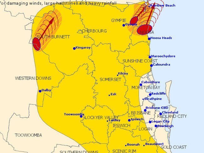
The Bureau has warned “destructive winds, very large hailstones and heavy rainfall” which could lead to flash flooding were all “likely” in affected areas.
Storms and hail in Cooroy. Photo: Andrew Mcmanus. Latest warning details: https://t.co/UW4rVZSwzd #qldweather #7News pic.twitter.com/dfTeU01cSP
— 7 News Sunshine Coast (@7NewsSC) October 8, 2018
BOM said the next warning would issued by 4.30pm.
A more general severe thunderstorm warning is also current for the Southeast Coast and parts of the Wide Bay and Burnett and Darling Downs and Granite Belt districts.

‘Gets pretty wild’: Qld weather buff on the spot for epic US storms
A Queensland weather forecaster shares unbelievable images after he spent almost three months chasing tornadoes in the US this year.

MINUS 3.1C: Brutal cold snap as Qld temps drop to lower than Hobart
Parts of Queensland have woken up to subzero temperatures which triggered widespread frost with the weather bureau warning the big freeze is going nowhere.