
Brisbane weather: Southeast Qld set for rain, possible storms
Falls of up to 50mm and possible thunderstorms forecast for parts of southeast Queensland heading into the weekend.
QLD weather news
Don't miss out on the headlines from QLD weather news. Followed categories will be added to My News.
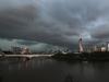
Gloomy conditions and sporadic showers across southeast Queensland are expected to intensify leading into the weekend, with the possibility of heavy rainfall and thunderstorms on Saturday.
Heavy and consistent rainfall will arrive by late Friday and bring wet and miserable conditions for the start of the weekend.
The Bureau of Meteorology’s Kimba Wong said Brisbane could experience up to 35mm overnight leading into Saturday, the Gold Coast and Sunshine Coast will get even higher totals, as much as 50mm, with the chance of isolated thunderstorms.
“We can expect very wet conditions for large parts of the southeast from Friday afternoon and most of Saturday, we will see two large rainbands converge over the region, one heading west from off the coast and an in-land system heading east and arriving late Friday,” Ms Wong said.
“It’s looking to be fairly miserable and gloomy conditions for the southeast corner, so if we do come out of lockdown it’s not going to be pleasant for most of Saturday anyway.”
Overnight, most of the southeast recorded less than 10mm of rain, with highest rainfalls recorded in spots such as Samford Valley (10mm) and Currumbin Creek (11mm).
The weather systems will clear by late Sunday, with cool and dry conditions to replace them.
“The systems will be cleared away by cool and dry conditions on Monday morning, temperatures will stay in the mid teens for most of the southeast, but usual suspects like Ipswich and Stanthorpe will see those lower single digits” Ms Wong said.
The Sunshine Coast has copped the brunt of rainfall in the past few days, with falls of more than 70mm in 24 hours.
CURRENT TEMPS & 7-DAY FORECASTS
More Coverage

Brisbane set to be smashed by storms, heavy rain
Brisbane and surrounding parts of the southeast are set to be smashed by storms and heavy rainfall this afternoon as a 3000km-long monster low moves across the state.

Wild storms, polar blast as 3000km monster low barrels towards Qld
The system, which stretches 3000km from north to south and encompasses 30 per cent of Australia, is forecast to pack a punch when it hits Queensland.