
Brisbane weather: Big wet sets in as ‘record breaking’ chill hits
Parts of Queensland have recorded huge rainfall figures over the past day as a massive falls in the past 24 hours, as a “record breaking” cold snap marks the start of summer. LATEST RAINFALL FIGURES
Summer is here but you wouldn’t know it, with December temperature records expected to tumble across the South East.
The state has recorded one of it coldest and wettest starts to summer, with some centres recording in excess of 160mm in the past day, while other areas woke to temperatures that felt like 6C.
Bureau meteorologist Pieter Claassen on Thursday afternoon said southern parts of Queensland were feeling the effects of a “giant airconditioning system”.
“We have cloudy conditions and fresh south-easterly winds bringing cooler and drier air from the south,” Mr Claassen said.
“So we basically have a giant airconditioning system – the process causes the water (the rain) to evaporate and it takes the heat out of the environment and cools the air around it.
“It’s the perfect thing – clouds, and rain falling into cooler, drier air.”
Mr Claassen said any potential temperature records would not be confirmed until 9am on Friday due to the data recording cycle, but several new milestones were possible.
Brisbane is on track to have its coldest December day on record – although records at the relevant measuring site only go back 23 years.
The same is expected for the Darling Downs. Toowoomba is heading for its coldest December day in 26 years of records, and Oakey is also set to reach the same milestone with 49 years of records.
The same records could also tumble in Moreton Bay with Beerburrum and Kingaroy temperatures a chance of falling short of the previous coldest December day.
In terms of rainfall, Bulgun Creek, near Tully in the state’s far north, recorded 164mm in the 24 hours to 9am on Thursday, with Tully itself getting 126mm in the same time frame.
Tourist hotspot Kuranda, near Cairns, got 117mm, while Koonandah, south of Bowen, got 92mm.
Springsure, in the Central Highlands, was hit with 75mm, while the Dawson Range, west of Gladstone, received 79mm.
Further south, Bundaberg copped 64mm, Biggenden got 50mm, Eidvold 86mm and Paradise Dam a whopping 103mm.
The South East received smaller rainfalls, with Mount Mee, northwest of Brisbane getting 51mm, while Maroochydore on the Sunshine Coast got 41mm and Maleny recorded 66mm.
Brisbane received 26mm.
The rain is expected to continue for Brisbane, the Gold Coast and Sunshine Coast throughout Thursday, easing to showers in the evening.
Meanwhile, it was just 10.6C in Applethorpe in the Southern Downs on Thursday morning, although it ‘felt like’ 8.9C, according to the weather bureau.
In Kingaroy the mercury dropped to 12.7C but felt like a chilly 8.5C, while at Double Island Point, near Rainbow Beach, in felt like 6.8C just before 6am, despite the thermometer sitting at 18.4C.
It was the coldest start to summer in Brisbane since at least 2000, with temps sitting at 15.8C in the early hours of the morning, although it felt like 13C at Brisbane Airport.
On the Gold Coast it felt like 11.8C at Coolangatta around the same time, while at Tewantin on the Sunshine Coast it felt like 11.7C.
“It’s definitely not a summery morning,” the Bureau’s Patch Clapp said.
“We’ve seen this from a combination of things: cloud cover, the rainfall over the past couple of days, plus a low sitting off the coast bringing some southerly winds,” he said.
“That low is bringing lower temperatures for the southeast across the board this morning.”
Brisbane is also today on track to break the record for lowest maximum temperature, with the mercury predicted to reach only 20C.
This will fall well under the 25.5C recorded in 2010, which currently holds the title.
Since 2000 the average temperature at the start of summer has been just under 27C, but the mercury is unlikely to reach that high until the middle of next week.
“With the low sitting off the coast we’re expecting the coastal fringe to see showers until Tuesday,” Mr Clapp said.
“We are seeing those temperatures warm up around then too – Monday around 26C and Wednesday a top of 30C for Brisbane.”
Bureau meteorologist Pieter Claassen said December temperature records could tumble on Thursday with southeast Queensland feeling the effects of a “giant airconditioning system”.
“We have cloudy conditions and fresh south-easterly winds bringing cooler and drier air from the south,” Mr Claassen said.
“So we basically have a giant airconditioning system – the process causes the water (the rain) to evaporate and it takes the heat out of the environment and cools the air around it.
“It’s the perfect thing – clouds, and rain falling into cooler, drier air.”
Mr Claassen said any potential temperature records would not be confirmed until 9am on Friday due to the data recording cycle, but several new milestones are possible.
Brisbane is on track to have its coldest December day on record – but it should be noted records at the relevant measuring site only go back 23 years.
The same is expected for the Darling Downs. Toowoomba is heading for its coldest December day in 26 years of records, and Oakey is also set to reach the same milestone with 49 years of records.
The same records could also tumble in Moreton Bay with Beerburrum and Kingaroy temperatures a chance of falling short of the previous coldest December day.
Scenic Rim farmer Ed Windley said rain and a cold start could further complicate crop yields.
“This cooler weather is slowing things right down, but we have back-up plantings and we’ll do everything we can to make sure the Christmas corn and beans get through,” Mr Windley said.
The Bureau is predicting below-median temperatures through to February.
It will not only be a colder start to summer, but a wet one, with a large weather system expected to bring heavy rainfall on Thursday.
The above-average rain is due to several climate drivers, including La Nina, a weakened negative Indian Ocean Dipole, a positive phase of the Southern Annular Mode, and record warm waters around Australia.
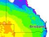
CURRENT TEMPS & 7-DAY FORECAST
More Coverage

Read related topics:Weather

