
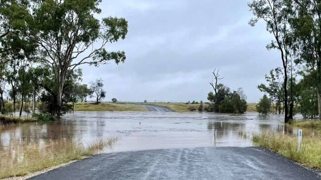
Central Highlands region in grips of flood emergency after 24 hours of intense rainfall
A flood emergency is unfolding in Queensland’s Central Highlands with some people losing everything. Now a new weather threat is on the horizon.
QLD weather news
Don't miss out on the headlines from QLD weather news. Followed categories will be added to My News.
Intense rainfall continues to drench large parts of Queensland, with a flood emergency active for the state’s central interior.
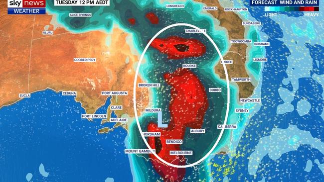
Now forecasters have warned a second band of heavy rain is creeping from west to east across the country that could extend the deluge and deliver more flooding in the week to come.
The Bureau of Meteorogoloy warns that heavy rainfall and flash flooding is likely to develop on the Capricornia region coastline late on Wednesday and into Thursday morning, with six hour rainfall totals between 100-200mm likely and intense falls in excess of 200mm possible.
Locations which may be affected include Gladstone, Yeppoon, Calliope and Byfield.
An Initial Minor Food Warning has been issued for the Maranoa and Upper Balonne rivers, with totals between 50-100mm recorded in the Maranoa River and Bungil Creek catchments in the 24 hours to 9am on Wednesday.
A Minor Flood Warning is current for the Paroo and Bulloo rivers in the state’s west however conditions are easing, while a Flood Warning remains in place for the Diamantina River.
The Diamantina River has flooded the Springvale Diamantina Lakes Rd Causeway however condititions are easing after peaking at 3m on Monday afternoon.
A Moderate Flood Warning is also current for the upper Warrago River with moderate flooding possible at Augathella overnight on Wednesday and into Thursday.
Rainfall totals of 125mm were recorded over parts of the catchment in the 24 hours to 9am on Wednesday with further showers and thunderstorms likely over the next few days.
Further south, some locations could see three times’ March’s rainfall descend in just a few days.
It’s almost certain that most parts of the NSW coast and into southern Queensland will at least surpass their average monthly rain in the coming week.
“Huge amounts of rain could fall over the next eight days,” Sky News Weather senior meteorologist Tom Saunders said.

The warnings come as central Queensland is in the midst of a flood emergency after a 200mm deluge in a matter of hours this morning.
An emergency alert has been issued for residents in Sapphire, west of Emerald, with the Retreat Creek rising rapidly and major flooding expected.
The heaviest rain fell at Grenada which has recorded 199mm.
A resident in the Gemfields region Riley Hardess said the impact of the floods has been devastating for some members of the community.
“It’s good to have the rain but it’s wrecked a lot of people’s homes and camps,” Ms Hardess said. “Some people have lost everything.”
“But it’ll put some feed on the common for the cattle and horses.”
Flash flooding overnight along Retreat Creek at Sapphire caused a rise of about 9m over just a few hours. It is currently easing slowly, with a level of 9.60m just after 9am today. Latest #QLDweatherhttps://t.co/9DfJpIIMVw#IfItsFloodedForgetItpic.twitter.com/Pc2OfwEt0A
— Bureau of Meteorology, Queensland (@BOM_Qld) March 16, 2021
Central Highlands Mayor Kerry Hayes said about 175mm fell in the Retreat Creek catchment in the early hours of Wednesday morning.
“Properties in low-lying areas are likely to be impacted. Council advises residents to warn neighbours, secure belongings and move to higher ground now,” the alert states.

A severe thunderstorm warning was issued for that region at 4.20am and remains active.
Severe thunderstorms are likely to produce heavy rainfall that may lead to flash flooding in the warning area over the next several hours.
Locations which may be affected include Clermont, Capella and Dysart.
Keilambete, northwest of Emerald, received 138mm in just three hours, while Barcaldine recorded 83mm in two hours.
The heaviest falls in the past 24 hours have occurred across the Fraser Coast and Central Highlands regions, with 115mm near Maryborough and 110mm at Paradise Dam.

Serpentine, a station southwest of Emerald, got 93mm in three hours, while Glenlee, near Rockhampton copped 99mm in three hours. Sunny Park, a station south of Clermont, got 91mm in two hours.
âš ï¸Severe Thunderstorm Warning for the #CentralHighlandsâš ï¸
— Bureau of Meteorology, Queensland (@BOM_Qld) March 16, 2021
Heavy with locally intense rainfall about the Gemfields is being observed. Intense rainfall can produce dangerous flash flooding. Local rivers are also responding with water levels rising. Warnings: https://t.co/Q4yc5B1B97pic.twitter.com/CMMqmVLMpt
Across southeast Queensland, the heaviest falls have been at Upper Springbrook, with 55mm in 24 hours, Bribie Island with 25mm and Mt Glorious with 24mm.
On the Darling Downs, 27mm has fallen at Oakey, 37mm at Thornville in the Toowoomba region and 28mm at Gatton, while Spring Bluff in the Lockyer Valley also recorded 34mm in the 24 hours to 9am on Wednesday.
It comes as Southeast Queenslanders were told to are brace for above-average rainfall over the next month, but dam operators warn it will take a “significant” dump of rain to affect catchment areas.
Bureau of Meteorology meteorologist Rosa Hoff said heavy falls would continue across southern Queensland today.
“There are potential thunderstorms likely inland where we could see 40mm recorded if there are concentrated, intense falls” she said.
“The coast and southeast corner may only see 10-30mm but inland in the Carnarvon Ranges, we are broadly looking at 30-60mm of rain which could increase to 100mm due to thunderstorms.”

It comes as climate modelling predicts above average rainfall is likely across the southeast for four weeks.
Meteorologist Matt Marshall said there was “a good chance” of above median rainfall for the end of March and “a moderate chance” of above median rainfall in April.
NEW RAIN BAND SET TO APPROACH
The system causing the incessant rain is already in place. But looking ahead a new moisture monster is approaching.
It looks like the rain just isn’t going to cease.
“A second bout of rain is starting to move across the interior,” Mr Saunders said.
“It will arrive early next week bringing widespread heavy rain potentially spreading through the southeast inland around him Murray Darling Basin.
“Over the next eight days that could bring over 50mm to north west NSW and south east Queensland, with 200mm for the NSW coast and Sydney likely to see around 100mm of rain.”
WILL IT HELP OUR DAMS?
But the wet weather has had little impact on the state’s struggling dams across southern Queensland.
Wivenhoe Dam, one of southeast’s largest water storage units and the main supply of water for Brisbane and Ipswich, received just received 39.2mm in the past week, bringing the dam’s capacity to 36.1 per cent.
The Moogerah Dam, located across Reynolds Creek only received 1.2mm and the Clarendon Dam in the Lockyer Valley only received 19mm.
“It would take a significant amount of constant rain to see any kind of significant increase it that Wivenhoe Dam catchment,” an SEQ Water spokesman said.
“People describe it as a green drought because our lawns are looking great.
“It’s mainly those coastal dams that are seeing the main rainfall occurring, Hinze Dam on the Gold Coast is at 100 per cent capacity, Wappa on the Sunshine Coast is at 100 per cent capacity but in the scheme of things they’re not a large part of the water supply for southeast Queensland.”
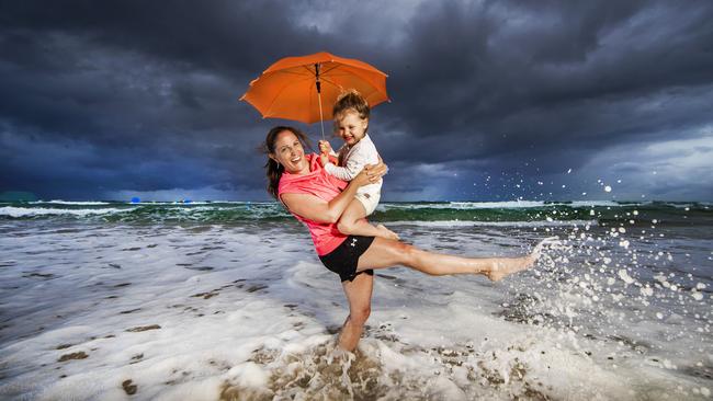
Victorian tourist Donna McDowall, 41 was unfortunate to miss out on the promised sunshine when her family flew up to Queensland over the weekend.
But they still made the most of the their time on the coast, taking daughter Chloe down to Main Beach for a swim.
“We try and make the effort to visit Queensland every year, seeing family and basking in the sunshine, but unfortunately the weather did not co-operate with our holiday plans” Donna said.
QLD’S BIGGEST RAINFALLS BETWEEN CLERMONT AND SPRINGSURE
Grenada - 199mm
Clermont - 119mm
Sunny Park - 132
Kilmarnok Station - 183mm
Florence Vale - 151mm
Keilambete Alert - 216mm
Rubyvale - 115mm
Willara - 113mm

Ice ice baby: Spectacular images of unseasonal frost as Qld freezes
Queensland’s overnight temperatures will increase to double digits in the coming days, following the coldest start to winter in 16 years, bringing frost and ice to many regions. SEE THE PHOTOS

City’s coldest June start in 16 years, feels like MINUS 9.8C out west
Southeast Queensland is shivering through its coldest morning in more than 15 years but feels-like temperatures have dropped to insane levels in the southern inland.