
72mm of rain in 24 hours falls in Dunwich, North Stradbroke Island
Rainfall is expected over the next few days in South East Queensland as onshore winds are expected to cool temperatures to “pretty close to average”, the Bureau says.
QLD weather news
Don't miss out on the headlines from QLD weather news. Followed categories will be added to My News.
More rainfall is expected after Monday morning’s showers led to 3-8mm of rainfall falling across the Sunshine Coast, Brisbane and the Gold Coast.
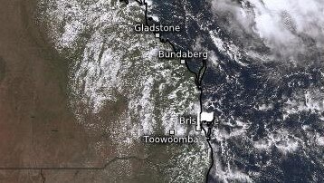
The heaviest rainfall in the South East occurred in Dunwich, North Stradbroke Island, with 27mm recorded in the past 24 hours.
Parts of the Sunshine Coast received more than 50mms of rain in under 24 hours while the city copped just over 10mms.
Bureau of Meteorology meteorologist Shane Kennedy said showers for the rest of Monday were expected to ease within the first half of the night before picking back up after midnight.
“Looking further ahead, expecting those onshore winds to start to weaken tomorrow, so Tuesday, and that should reduce the chance of showers,” he said.
“Still likely to see a few (showers) tomorrow becoming a bit more spread out, a bit more hit and miss, so dropping down to a 30 per cent chance for Brisbane; a 40 per cent chance for the Gold Coast.
“There’s a high chance (of showers) for the Sunshine Coast.
“It will take a little bit longer to calm down there, dropping to around a 70 per cent chance tomorrow.”
Sunshine Coast could see 5-15mm of rain over the next few days while winds and the chance of showers will continue to decrease from Wednesday.
Mr Kennedy said the Central Coast had been an exception to the light rainfall overnight, getting falls of 40-80mm.
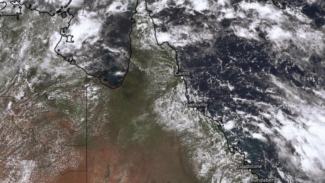
“We could see some similar moderate rainfall around that Central Coast region for the next couple of days… there’s also an upper trough so a trough high up in the atmosphere that’s a bit unstable over that region so that was what helped give some of the thunderstorms between Mackay to Gympie yesterday,” he said.
“It could be similar, could be a storm or two down to around that Gympie region today – (we) should not expect that heavy rainfall, but could be little to moderate rainfall for the Central Coast.
“That’s the only anomaly but elsewhere rainfall is already easing.”
A monsoon trough is also expected to develop through the Torres Strait today, but Mr Kennedy said it was expected to stay through the Torres Strait and was not expected to have a big impact on Queensland.
“Could see some locally heavy rainfall over the Torres Strait… shouldn’t affect the Tropical Coast,” he said.
“Next weekend we might start to see that monsoon trough start to drift south particularly if we get a tropical low or two falling… (but) no bit of danger or any tropical lows or cyclones at this stage but that will be a watch point towards the end of this week.”
While temperatures drop down to “slightly above average”, lots of sunshine was expected this week in southern central and far southwest Queensland, Mr Kennedy said.
“Temperatures generally pretty close to average, it will be slightly above average in the far southwest just with more sunshine but elsewhere will be pretty close to average,” he said.
The bureau have issued multiple hazardous surf warnings, with the K’gari Coast, Sunshine Coast and Gold Coast all on high alert for hazardous wave and surf conditions for both Monday night and Tuesday.
As well as high rainfall totals, Cape Moreton clocked 78km/h wind gusts just after 9.30am. Gold Coast Seaway also copped 69km/h wind speed at 12.40pm

Hail, rain, wind, SNOW: Winter storm on Qld collision course
A rare winter storm threatens to dump 15cm of snow on Queensland's Granite Belt this weekend as forecasters warn of an incoming polar air mass.

‘Can’t be ruled out’: Potential for freak Qld snowfall this week
Queensland could see snow this week with weather models predicting up to 14cm falling on the Granite Belt.