
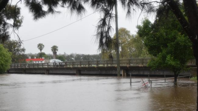
Warwick floods: OO Madsen Bridge to remain open as Condamine River peaks
Huge flood levels from the Condamine River have inundated parts of Warwick, with residents battling more than 60 road closures and the threat of more rain within days. FULL UPDATE HERE:
Warwick
Don't miss out on the headlines from Warwick. Followed categories will be added to My News.
Authorities remain on high alert across the region as flooding continues to sweep Warwick and its surrounds following a wild 24 hours of weather.
Rainfall data from the Bureau of Meteorology says Warwick received 78mm between 9am on Tuesday and the same time on Wednesday, while Environdata indicates a higher total of 86.8mm.
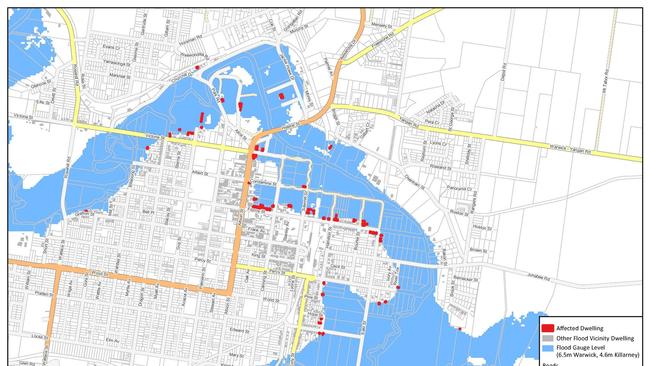
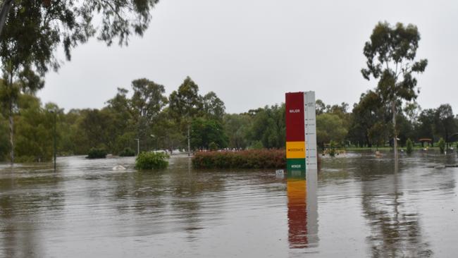
The whopping 24-hour deluge pushed the Condamine River to flood with a peak level between 6.2m and 6.5m on Wednesday morning, falling just short of the 6.66m height recorded in the March floods earlier this year.
SDRC deputy local disaster coordinator Patrick Doyle said the river did not rise as high as expected in those smaller communities, inundating parts of properties but leaving homes and buildings untouched.
He said no sandbags were required at this stage and no one was evacuated.
“There’s lots of road closures across both Warwick and Stanthorpe and the outlying areas, and we’re just continuing to monitor those today,” he said.
“Reopening will depend on a number of things, including the individual area and how far under they are, how quickly the water is going down, and if there’s been any damage once the water has gone down and we can see more clearly.
“Connolly and Storm King Dams are both topping over, but there’s no plans to release extra water and no one has been affected apart from the flooding that’s already obvious.”
Mr Doyle said OO Madsen Bridge in Warwick came under the Department of Transport and Main Roads rather than the council, but its closure seemed unlikely with the Condamine due to peak below the bridge height.
The latest weather forecasts predict the worst is over this week for Warwick and the wider Southern Downs, but it won’t be long before the rain returns.
BOM meteorologist Pieter Claassen said there was a slight risk of storms and showers across the region on Wednesday afternoon, with the wet weather system to completely clear by Thursday.
“There’s a risk of seeing some decent rainfall out of those (storms) if they do occur, but it’s going to be very isolated and sporadic,” he said.
“There might be a bit of a pick up again late in the weekend, but even showers and storms can result in pretty quick flash flooding and even riverine flooding with how saturated we are.
“We’ll be watching the regions quite closely for any weather that could cause more flooding problems.”
Warwick currently has a 40 to 60 per cent chance of light rain from Saturday through to Tuesday.
It comes after heavy overnight rainfall pushed the Condamine River above previously predicted moderate flood levels, with Warwick residents being urged to prepare now for flooding.
The latest modelling from the Bureau of Meteorology predicts the Condamine River will hit 6.5m at about 7am on Wednesday, up from the possible 6m indicated on Tuesday night.
It is also expected that the river will peak in Pratten at 7.3m by Wednesday afternoon, with Southern Downs Regional Council and the Rural Fire Service completing door knocks to affected properties in the area.
BOM rain gauges have recorded 70mm of rain in Warwick since 9am on Tuesday, with a huge 112mm at Spring Creek Road and 81mm at Emu Creek and Yangan.
The Environdata weather gauge on Percy Street has recorded even higher totals of 79.6m in the Rose City.
Residents in other areas of the region including Stanthorpe and Allora are being urged to stay vigilant and avoid roads affected by flash flooding.
The Leyburn community was expected to see major flood levels of up to 4.2m in the early hours of Wednesday morning after receiving at least 60mm in just under 24 hours.
The whopping rainfall totals have sent Leslie Dam levels skyrocketing to 95.8 per cent, up more than 10 per cent from its 84.79 reading on Tuesday evening.
Other parts of the Southern Downs have experienced even more extreme conditions, with an emergency flooding situation still under way in Inglewood.
Police made the emergency declaration at about 9pm on Tuesday after more than 70mm of rain fell in less than 24 hours, driving significant flooding from the Macintyre Brook catchment.
Emergency services evacuated residents to the Inglewood Cemetery, with properties in the area likely to have experienced internal and external flooding.
Call the SES on 132 500 for emergency assistance or triple-zero for life-threatening situations.
Residents have reported flash flooding across Leslie Dam Road, Warner Street, and Glen Road at Leslie Dam, but these are yet to be confirmed by SDRC.
All flood-damaged roads should be reported to SDRC as soon as possible via the My SDRC App.
See the full list of current flood-affected roads across the Southern Downs here:
Rosehill Road – Wallace Street, Warwick
Bracker Road, Warwick
McEvoy Street, Warwick
Grafton Street, Warwick
Churchill Drive, Warwick
Percy Street, Warwick
Coe Street, Warwick
Mangan Street, Warwick
Ogilvie Road, Warwick
East Street, Warwick
Lyndhurst Lane - Lyndhurst Road, Rosenthal Heights
Homestead Road, Rosenthal Heights
Andersons Crossing Road, Loch Lomond
Mapes Road, Loch Lomond
Warwick Killarney Road
Tourist Drive 1, Murrays Bridge
Warwick Yangan Road, Swan Creek
Jack Smith Gully Road, Swan Creek
Condamine River Road, The Head
Tucker Road, Emu Vale
Hermitage Emu Vale Road, Yangan
Jingary Mt Stuart Road, Yangan
Roona Road, Junabee
Longs Bridge Road, Junabee
Kirkland Road, Massie
Bony Mountain Road, Massie
Dwan Lane, Bony Mountain
Connells Bridge Road, Bony Mountain
Talgai West Road, Talgai
Toolburra Plains Road, Toolburra
Wheatvale Plains Road, Upper Wheatvale
Cunningham Highway, Wheatvale (near Oaky Creek)
School of Arts Road, Pratten
Toowoomba Karara Road, Leyburn
Toowoomba Karara Road at Costello Bridge, Karara
Glen Niven Road, Glen Niven (long-term closure due to loss of floodway)
Amosfield Road, Dalcouth
Gillbard Road, Dalcouth
Granite Street, Stanthorpe
Marino Road, Broadwater
Elks Lane, Broadwater
New England Highway, Lyra
Pyramids Road, Wyberba
Emu Swamp Road, Somme
Walters Road - Mt Stirling Road, Glen Aplin
Stanthorpe Texas Road, Pikes Creek
Boatfields Road, Amiens
Barracks Road, Amiens


Fireys battle large grass fire near Warwick
Fireys are working to contain a fast-moving grass fire near Warwick. Here’s the latest.

Unveiled: Alleged teen crims front court on combined 82 charges
Juveniles, charged with almost 100 offences, fronted Toowoomba court for a range of alleged crimes, from a violent sickle robbery to petty theft.